Geo-spatial Targets for Disaster Management and Mitigation Planning
180 likes | 274 Vues
This project aims to enhance disaster management through space-based observations, in-situ monitoring, and system integration, addressing critical needs such as SAR, soil moisture, seismic activities, and early warning systems. It focuses on developing new technologies for hazard detection and response, and improving data access and sharing for rapid decision-making. The collaboration between CEOS and space agencies plays a crucial role in achieving these objectives.

Geo-spatial Targets for Disaster Management and Mitigation Planning
E N D
Presentation Transcript
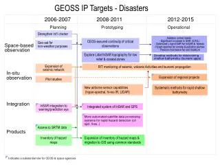
GEOSS IP Targets - Disasters 2006-2007 2008-2011 2012-2015 Prototyping Planning Operational Strengthen Int’l charter Address unmet needs: - Significant increase in SAR (C/X/L) - Optimized L-band SAR for InSAR & forests - Hyper-spectral for smoke & pollution plumes- Passive microwave for soil moisture CEOS-assured continuity of critical observations Geo-sat for non-weather purposes Space-based observation Explore Lidar/InSAR topography for low relief & coastal zones Develop methods for determining shallow bathymetry (tsunami apps) R/T monitoring of seismic, volcanic Activities and tsunami propagation Expansion of seismic network In-situ observation Expansion of regional projects Pilot studies New airborne sensor capabilities (hyper-spectral, hi-res IR, LIDAR) Systematic methods for rapid shallow bathymetry Integration InSAR integration to warning/prediction sys Integrated system of InSAR and GPS More automated satellite data processing systems for rapid hazard detection (oil spill, fires..) Access to SRTM data Products Inventory of hazard maps Expansion of inventory of hazard maps & migration to GIS using common standards Indicates a substantial role for CEOS & space agencies
GEOSS IP Targets - Health 2006-2007 2008-2011 2012-2015 Planning Prototyping Operational Space-based observation Define High resolution sensors for health observations Derive wide-area health parameters from satellite Spec for new major obs capabilities Plan to fill-in RS gaps with necessary in-situ observations In-situ observation Spec for New major obs capabilities Improved methods to fill in gaps Better disease surveillance Products & services integratingEarth science DBs with health info Inventory of EO DBs with potential health applications Integration Integrated Health information network database Develop early detection sys for health-related change Facilitate early detection and control of environmental risks Products Improve access to historical RS data for health applns RS maps of gasses, aerosols, pollution Develop models relating RS datato epidemiology or disease Develop human health indicators based on environmental measure Models User IF Define observation & data requirements Coordination group of health organisations as EO users Formation of global community
GEOSS IP Targets - Energy 2006-2007 2008-2011 2012-2015 Planning Prototyping Operational Implement operational observing system - reliable & timely data for energy sector Space-based observation Implement operational observing system In-situ observation Integration Product Exchange & use of data/products, forecast information New energy-tailored products and services Model Support development of new generation weather and climate models Strategic plan Develop strategic planto use new generation systems Evaluation and revision of strategic plan
GEOSS IP Targets - Climate 2006-2007 2008-2011 2012-2015 Planning Prototyping Operational Implement GCOS-IP and IGOS Theme reports (59 CEOS actions identified) Space-based observation Support research for devt of observations of key ECVs: ozone, aerosols, CO2.. Dev. and operate new instruments for ECVs Implement baseline networks: GSN, GUAN, etc. In-situ observation Implement GCOS-IP and IGOS Theme reports Dev. and operate new instruments for ECVs Intergovernmental mechanism for the terrestrial domain Establish data archive centers for ECVs, commitments for integrated global analysis of ECVs Integrated obs sys for Atmospheric chemistry Integration Promote re-analysis program Develop data integration facilities Model Advances in predictability of climate Establish strong international co-ord mechanisms (obs. orgs,researchers, users) Strategic plan Develop a long-term strategyfor obs, data assimilation and modeling
3 hourly global precipitation Plan water quality monitoring GEOSS IP Targets - Water 2006-2007 2008-2011 2012-2015 Planning Prototyping Operational GPM & Missions for surface & subsurface water stores Space-based observation Study capabilities for: - surface water quality- streamflow and water storage (altimeters) Gravity mission for ground water stores Improve existing in-situ sys In-situ observation Plan integrated in-situ network Test global net of integrated in-situ sites Make integrated in-situ obs site operational Int’l coord. mechanisms Water level data collection sys Operational integrated data system Integration Implementation plan for data integration system Test a fully integrated prototype data system with assimilation, analysis & visualisation System for monitoring WC changes Routine watershed health indicators New products for precipitation, soil moisture, evaporation and evapotranspiration Integrated precip. and soil moisture products (IGOS-P) Data and info on water quantity and qualityto protoype expert decision support sys Product Integrated water cycle data sets Integrated info on climate indices/ extreme events Model Framework for ensemble hydro prediction User IF Collaborative mechanism between obs and research community
GEOSS IP Targets - Weather 2006-2007 2008-2011 2012-2015 Planning Prototyping Operational Support WMO activities to improve data observation & models of severe weather events & associated early warning systems - inc regional centres in dev. countries • New observation systems to • cover specific observations • wind&humidity profiles at all levels- temp profiles with adeq. vert resn in cloudy areas • precipitation- soil moisture- surface pressure • snow equivalent water content- etc Invest in critical data gaps (wind & humidity profiles, ocean evaporation, soil moisture, precipitation) Space-based observation Invest in critical data gaps In-situ observation Support WMO plan for regional in-situ observation networks based on EUCOS model Support WMO for EUCOS expansion feasibility Support WMO activities to improve data observation & models of severe weather events & associated early warning systems - inc regional centres in dev. countries Sustained operations of dev. country regional centers for severe weather warnings Integration Improve predictive models Support WMO to Improve data and models Model
GEOSS IP Targets - Ecosystem 2006-2007 2008-2011 2012-2015 Planning Prototyping Operational Planning Implement IGOS Carbon observing system Continuity of moderate to high-resolution EO satellites for Land cover & ocean colour Space-based observation Global ecosystem mapping at 500 m resolution Study new sensors and platforms Validate SAR and hyper spectral images Global in-situ and airbone networks for satellite validation In-situ observation Coordinate ecosystem reference site network Networking of obs institutions Implement IGOS Carbon observing system Implement global nitrogen obs system Globally agreed ecosystem classification scheme Spatially-resolved information onecosystem change to deliver sustainable ecosystem services Integration Develop scale up tools Monitoring of urban ecosystems Eliminate regional disparityin observations Product Rescue historical information Baseline maps of global ecosystem properties
GEOSS IP Targets - Agriculture 2006-2007 2008-2011 2012-2015 Prototyping Operational Planning Land cover mapping of 1:1M Global land cover product at 1:500,000 Global production capabilities:Land cover obs for 1:250,000 Land use obs for 1:500,000 Space-based observation Establish role of satellite data in global farming systems database Use of geo-sat data in food-insecure regions Establish basis for continuity of high resolution optical/radar sats (5-30m) Continuity of high-resolution imagery for monitoring logging in key biodiverse regions Support completion of world soil and terrestrial DB at 1:1M In-situ observation On-time monitoring andinfo sys for significant eventsfire, forest conversion, forest management On-time monitoring andinfo sys for significant events -crop yields and crop water stress On-time monitor and info sys for significant event for landdegradation and desertification Fully integ obs sys for on-time drought EWSfor food-insecure regions Integration Use of agriculture, forestry, fishery production statistics to pixel level Operational linkage of EO data to production and usage statistics Socio-economic data converted to pixel Analytical tools and methods for agriculture risk assessment Global DB and assessment of agriculture Product Global irrigated agriculture map & monitoring
GEOSS IP Targets - Biodiversity 2006-2007 2008-2011 2012-2015 Prototyping Planning Operational Space-based observation None identified In-situ observation Monitor sys for endangered species Distributed obs network interoperable through GBIF Obs network optimized incl. development of new sites Systematic monitor of biodiv. in all ecosystems Capture 10M new obs Capture 12M new obs per annum Addition of 15M new data points yearlyplus trend and analysis capabilities Distributed biodiversity network integrated into policy system Support data sys integration Near-real time data on detection of Invasive organisms Integration Full operationality and integration of citizen-based obs sys Product Timely data and info for policy makers Develop obs strategies to support 2010CBD targets Strategic plan Strategy for citizen-based Biodiversity obs system
GEOSS IP Targets - Commonalities 2006-2007 2008-2011 2012-2015 Planning Prototyping Operational Strategic and tactical guidance on how to converge sys and interoperability Joint evaluation of prototype sys of sys and operational research demonstration Integration Periodic demo of overall progress of interoperability achieved towards the GEOSS Interoperability among data sets Formal commitments Sharing of best practice for development of products customized for specific SBA Product Optimum use of GEOSS data and info Strategic plan Plan to sustain and evolve sys of sys beyond 10 years
GEOSS IP Targets - Architecture 2006-2007 2008-2011 2012-2015 In-situ observation Baseline sites for global in-situ networks Formal commitments - incl. to interoperability Integration Network-distributed catalogue of GEOSS participants and components Process for reaching interoperability Use of SDI components in areas such as geodetic reference frames, common geographic data Cost-and-benefit sharing mechanism to assist devt. of optimal obs. systems Framework for future continuity of obs and initiating new obs Analysis of systems for data transfer & dissemination by GEOSS members Common understanding on future global data dissemination capability
GEOSS IP Targets – Data & Users 2006-2007 2008-2011 2012-2015 Prototyping Operational Planning Mechanism for coordinating user needs within SBAs Sharing of data and products and their Use in decision making support International info sharing capabilities, incl. Internet-based services Integration Life cycle data management, incl. analysis, visualization of large volume data Efforts for enhanced data availability and usability beyond 10 years Common data, metadata, products across SBAs Product Strategic plan Protection of radio frequency
GEOSS IP Targets – Capacity Building 2006-2007 2008-2011 2012-2015 Planning Prototyping Operational Comprehensive review and gap analysis Produce monitoring and evaluation mechanism of CB efforts Sustained CB strategy that significantly strengthens capabilities of DCs in: -use, access, analysis, integrate dataand products, improve infrastructure Strategic plan Methodologies to monitor and evaluate CB initiatives for EO Recommended priorities for new CB Encourage CB components in SBAs Education /Training Strengthen education, research and communications Education and training to provide a global base of technical expertise Network of experts Establish baseline sites for global in-situ and RS networks Institutional /Infrastruct. Funding of multinational projects, incl. establishment of infrastructure Facilitate access to data and models particularly for developing Countries
GEOSS IP Targets - Outreach 2006-2007 2008-2011 2012-2015 Planning Prototyping Operational Outreach Implement outreach plan All target audience should be reached
A system of Systems - Space-based observation - 2006-2007 2008-2011 2012-2015 Address unmet needs: - Significant increase in SAR (C/X/L) - Optimized L-band SAR for InSAR & forests - Hyper-spectral for smoke & pollution plumes- Passive microwave for soil moisture CEOS-assured continuity of critical observation Strengthen Int’l charter Disaster Geo for non-weather purposes Explore lidar/InSAR topography for low relief& coastal zones Health Define hi-res sensors for health observations RS maps for gasses and aerosols, pollutions Develop methods for determining shallow bathymetry (tsunami apps) Define wide-area health parameters from sat Spec for new major obs capabilities Plan to fill-in RS gaps with necessaryin-situ observations Energy Implement operational observing system - reliable & timely data for energy sector Climate Implement GCOS-IP and IGOS Theme reports (59 actions identified) Support research program for devt of obs of key ECVs: ozone, aerosols, CO2.. Dev. and operate new instruments for ECVs Routine watershed health indicators 3 hourly global precipitation GPM & missions for surfaceand subsurface water stores Water cycle Study capabilities for: - surface water quality- streamflow and water storage (altimeters) Plan water quality monitoring Gravity mission for ground water stores • New observation systems to • cover specific observations • wind&humidity profiles at all levels- temp profiles with adeq. vert resn in cloudy areas • precipitation- soil moisture- surface pressure • snow equivalent water content- etc Invest in critical data gaps (wind & humidity profiles, ocean evaporation, soil moisture, precipitation) Support WMO activities to improve data observation & models of severe weather events & associated early warning systems - inc regional centres in dev. countries Weather Ecosystem Continuity of moderate to high-resolution EO satellites for land cover & ocean colour Global ecosystem mapping at 500 m resolution Study new sensors and platforms Implement IGOS Carbon observing system Establish utility of SAR & hyperspectral Agriculture Global land cover product at 1:500,000 Land cover mapping of 1:1M Global production capabilities: Land cover obs for 1:250,000 Land use obs for 1:500,000 Use of geo sat data In food insecure regions Establish role of sat data in global farm sys DB Continuity of high resolution optical/radar sats (5-30m)
A system of Systems - Integration - 2006-2007 2008-2011 2012-2015 Disaster InSAR integration to warning and prediction system Integrated system of InSAR and GPS Health Products and services integrating Earth science DBs with health info Inventory of EO DBs with potential health applications Facilitate early detection and control of environmental risks Integrated Health info network database Develop early detection system for health-related change Establish data archive centers for ECVs, commitments for integrated global analysis of ECVs Climate Integrated obs sys for atmos. chem. Develop data integration facilities Promote reanalysis program Water cycle Test a fully integrated prototype data systemwith assimilation, analysis & visualisation Operational integrated data system Implementation plan for dataintegration system System for monitoring WC changes Support WMO for new regional dev ctry centers for severe weather warning Weather Sustained operations of regional centers Ecosystem Implement IGOS Carbon obs system Implement global nitrogen obs sys Spatially-resolved information on ecosystem change for sustainable ecosystem services Globally agreed classn. scheme Develop scale up tools Monitoring of urban ecosystems Eliminate regional disparity On-time monitor and info sys for landdegradation and desertification On-time monitoring & infosys for significant events On-time monitoring andinfo sys for significant events:- fire, forest conversion & mgt Agriculture Fully integ obs sys for on-time drought EWS Use of agriculture, forestry, fishery production statistics to a pixel level Operational linkage of EO data to statistics Socio-economic data converted to pixel Analytical tools and methods for Agriculture risk asessment Global DB and assessment of agriculture Biodiversity Near-real time data on invasive organisms Distributed biodiversity network integrated into policy system Support data sys integration Full operationality and integration of citizen-based obs sys
A system of Systems - Products - 2006-2007 2008-2011 2012-2015 Disaster Access to SRTM data Inventory of hazard maps Expansion of inventory of hazard maps RS maps of gasses, aerosols, pollution Health Historical RS data Exchange & use of data/products, forecast info Energy New energy tailored products and services Integrated precip. and soil moisture products(IGOS-P) New products for precipitation, soil moisture, evaporation and evapotranspiration Data and info on water quantity and quality to prototype expert decision support system Water cycle Integrated info on climate indices/ extreme events Integrated water cycle data sets Weather Ecosystem Rescue historical info Baseline maps of global ecosystem properties Agriculture Global irrigated maps Biodiversity Timely data and info for policy makers
A system of Systems - Model - 2006-2007 2008-2011 2012-2015 Health Develop human health indicators based on environmental measure Develop model relating RS datato epidemiology or disease Support development of newgeneration weather and climate models Energy Advance in predictability of climate Climate Framework for ensemble hydrologic prediction Water Prototype expert decision support system Support WMO to Improve data and models Weather Improve predictive models Ecosystem