Pressure systems, air masses & fronts
220 likes | 439 Vues
Pressure systems, air masses & fronts. Basic Meteorology Oklahoma Climatological Survey. PRESSURE SYSTEMS. Pressure makes the wind blow. Wind is simply air molecules in motion We “see” wind through the force of these molecules on objects, such as leaves

Pressure systems, air masses & fronts
E N D
Presentation Transcript
Pressure systems, air masses & fronts Basic Meteorology Oklahoma Climatological Survey
Pressure makes the wind blow • Wind is simply air molecules in motion • We “see” wind through the force of these molecules on objects, such as leaves • Air moves from areas of high pressure to low pressure • Recall density – molecules are packed more tightly together when pressure is high, so they want to spread out a bit Source: NOAA National Weather Service Jetstream
Pressure makes the wind blow • But remember all that stuff about the Earth’s rotation? • The Coriolis forceturns air parcels to the right (in the northern hemisphere) • This causes air to ‘spin’ around the pressure centers • The air would end up going around in circles around the pressure centers except for friction • Friction slows wind speeds, lessening the effects of the Coriolis force • Air moving away from high pressure creates divergence at the surface, drawing air downward from aloft • Air moving toward low pressure creates convergenceat the surface, forcing air upward near the low’s center Source: NOAA National Weather Service Jetstream
Low vs. High Pressure (N. Hemis.) L H L H L H Surface convergence rising motion Surface divergence sinking motion Clockwise (anticyclonic) flow Counter-clockwise (cyclonic) flow In the Northern Hemisphere, if you stand with your back to the wind, then the lower pressure will be to your left.
Remember This? • Air in motion brings with it characteristics of its source region • These characteristics are called an air mass • Boundaries between air masses are called fronts
Types of Air Masses • Air masses are distinguished by one of four source characteristics: • Polar (sometimes called Arctic) • Tropical • Continental (land regions) • Maritime (water regions) • As air masses move, they become modified such that they show characteristics of two source regions • cP = continental Polar • mT = maritime Tropical
Air Masses of North America (1) cP and cAContinental Polar and Continental Arctic Cold (very cold in winter) and dry, stable conditions (2) mPMaritime Polar Cool, moist and somewhat unstable. Forms in polar regions, then moves over oceans. (3) mT Maritime Tropical Very warm and moist. Forms over the eastern Pacific and the Caribbean sea and Gulf of Mexico. (4) cT Continental Tropical Hot, dry and unstable conditions. Forms over northern Mexico and the southwestern U.S. during the summer. Source: NOAA National Weather Service Jetstream
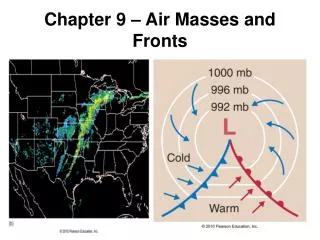
Fronts • Fronts are the boundaries between air masses • Fronts are defined by the characteristics of the air mass it is replacing: • Cold front: colder air is replacing relatively warmer air • Warm front: warmer air is replacing relatively colder air • Stationary front: neither air mass is moving • Occluded front: a cold air mass (cold front) has overtaken a warmer air mass (warm front), lifting the warm layer aloft • Dryline: like a front, but a sharp contrast in moisture (humidity) more so than temperature • Fronts are three-dimensional • Their slope determines the types of clouds that form along the boundaries Dryline
Cold Front • A cold front is a boundary where a cold air mass is replacing a warm air mass. • Blue triangles point in the direction of movement. • Air on the warm side is lifted rapidly over cold air air rises and cools condensation begins and clouds form, heavy showers may fall • Cumulus clouds are associated with cold fronts. • A cold front moves faster than a warm front. Bird’s-eye View Side View Colder air Warmer air
Warm Front • A warm front is a boundary between an advancing warm air mass and a retreating cold air mass. • Red half circles point in the direction of motion. • Warm air rises over cold air at a slant, which leads to gradual lift. • Stratus, altostratus, and cirrus are associated with warm fronts. Side View Bird’s-eye View Colder air Warmer air
Occluded Front • An occluded front occurs when a cold front catches up to and overtakes a warm front (because the cold front moves faster than the warm front). • It is shown as a purple line with alternating purple triangles and half circles. • Cirrus, altostratus, and stratus are followed by cumulus and possibly heavy showers. N Precipitation Warm Occluded front Cold Cool Cool Warm Initial occlusion Cold Cold Cool Pre-occlusion Height Warm Cold Cool Warm
Stationary Front • A stationary front experiences very little to no movement. • Two air masses are at a “stand-off,” waiting for one to make a move. • The wind blows parallel to the front, but in opposite directions. You first! I dare you to move… Cold air mass Warm air mass
Identifying Fronts • Now we know the front types…but how do we find them? • Radar • Weather map • Fronts on Radar • Cold front—Precipitation is mostly behind the front, but there is some before and along the front. There is a convective band (high echo values) with a stratiform band (low echo values). • Warm front—Precipitation is mainly before the front, with some along the front. The precipitation is mainly stratiform (low echo values). • Occluded front—Precipitation falls before, behind, and along the front. • Stationary front—There is no precipitation if both air masses are dry; if there is enough moisture, precipitation can fall over the same area for a while, which can lead to flooding!
50 knots 10 knots 5 knots 1 knot = 1.15 mph Identifying Fronts on Weather Map • Sharp temperature changes over relatively short distance • Changes in moisture content (dew point changes) • Wind direction shifts • Pressure and pressure changes • Clouds and precipitation patterns (seen in radar/satellite) L H H 33 35 28 14 20 30 25 19 31 16 34 33 17 22 Air mass 2 Air mass 1 30 32 20 15 33 28 17 23 32 35 26 15
Identifying Fronts on Weather Map • Cold front • Coolertemperatures with frontal passage • Lowerdewpoint temp. with frontal passage • Winds: S/SW before front, W/NW after front • Warm front • Warmertemperatures with frontal passage • Higherdewpoint temp. with frontal passage • Winds: S/SE before front, S/SW after front • Occluded front • Oftencoolertemperatures with frontal passage • Slightly lowerdewpoint temp. with frontal passage • Winds: E/SE/S before front, W/NW after front
Identify the Fronts 35 40 42 42 50 44 46 43 45 41 49 42 40 44 45 42 48 46 37 45 47 42 43 41 48 40 50 46 48 47 49 50 38 43 46 35 43 49 50 47 45 21 28 25 40 27 30 43 42 40 45 47 50
Cold dry air cP cT Warm dry air mT Warm moist air Dryline • Smaller scale than other fronts • Mainly seen in the Plains states, especially in W Texas, OK and KS (spring/early summer) • Narrow zone where there is a sharp change in moisture (dewpoint temperature) • Black or brown scalloped line • Separates warm, dry air and warm, moist air • Severe thunderstorms (e.g., supercells) can form along the dryline. L