Download
1 / 34
350 likes | 440 Vues
Discover the history of 'Perfect Droughts' in Southern California through insightful research. Learn about the impacts on water sources, tree-ring data, and predictions for the future. Explore the connections to the Colorado River basin and the Southwest region in this comprehensive dialogue. Gain a deeper understanding of drought patterns, climate changes, and the complex factors influencing water availability in these areas.

E N D
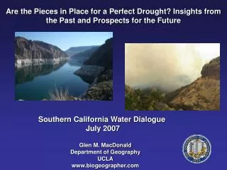
Are the Pieces in Place for a Perfect Drought? Insights from the Past and Prospects for the Future Southern California Water Dialogue July 2007 Glen M. MacDonald Department of Geography UCLA www.biogeographer.com
‘Perfect Droughts’ Impact all of Southern California Water Sources MacDonald, G.M., Rian, S. and Hidalgo, H. 2005. Southern California and the perfect drought. Colorado Basin Climate, California Department of Water Resources, pp 50-57 (Map).
Jan. 1988 – Dec. 1991 MacDonald et al. in press
MacDonald, G.M., Rian, S. and Hidalgo, H. 2005. Southern California and the perfect drought. Colorado Basin Climate, California Department of Water Resources, pp 50-57. MacDonald, 2007, Quaternary International
Cook, E. et al. 2004. Long-term aridity changes in the western United States. Science 306: 1016-1018
adjR2 0.39 adjR2 0.49 adjR2 0.50 MacDonald et al. in press
Perfect Droughts ~AD 1012-1076 ~AD 1130-1192 MacDonald et al. in press
25-Year Running Mean • 13 consecutive years of below-normal flow (longest stretch in the gage record was 5 years) • 62-year window without any very wet years Meko and Woodhouse, 2007
Perfect Drought Periods (~60 years) ~AD 1012-1075 ~AD 1130-1192 Depressed E Tropical and NE Pacific SST’s and prolonged droughts in California and Colorado Bsin during Medieval Warm Period. (Mann et al. 2005; MacDonald and Case, 2005, MacDonald et al. in press)
PERSPECTIVE FROM THE COLORADO RIVER AND THE SOUTHWEST Connie A. Woodhouse Department of Geography and Regional Development University of Arizona • Main Points • The Colorado River, an important source of water for 7 US states and Mexico, is over-allocated, a situation exacerbated by growth and drought. • Extended records of streamflow from tree rings place recent droughts in a 500-year context: 20th-21st c droughts are not unusual. • A new longer reconstruction, 762-2005, offers a regional perspective on a period known for widespread drought: the most persistent Colorado River basin drought occurred in the 1100s. • Understanding drought in the Colorado River basin: linked to El Nino/Southern Oscillation (ENSO), but other controls may be important also.
The Colorado River Compact, signed in 1922, was based a record of streamflow from a period of time with unusually high flows. Over-allocation + increased demands + drought = stressed system
Tree-ring data extend the gage record back in time and allow the recent drought to be evaluated in a long-term context Tree-Ring Reconstructed Colorado River Flow, 1490-1997 Lowest 5-yr mean in gage record, 2000-2004
Old And New Tree-Ring Networks Used To Produce PDSI Reconstructions For The North American Drought Atlas Version 1 Tree-Ring Network Version 2 Tree-Ring Network
NW SW MX MCA aridity appears to be best expressed in the ‘SouthWest’ and Mexico where tropical Pacific SSTs have the strongest impact. <1/2 COVERAGE >2/3 COVERAGE
Palmer drought severity index(PDSI) (Dai et al. 1998) Summer PDSI = JJA average (integrates winter-spring-summer) Recent drought began in 1994 in Mexico Most severe and sustained in Mexico 12 consecutive years in central Mexico (and not over) Unmatched in the instrumental record Intense warming over Mexico contributing to PDSI trend Tree-ring reconstructed summer PDSI used to calculate Drought Area Index (DAI) for Mexico Recent drought unprecedented in 500 years? Predicted aridity trend already underway in Mexico? Central Mexico Mexico
Northeastern Pacific SST Drought Depressed NE Pacific SST’s and Continuous drought in California during Holocene Warm Period ~8000 – 3000 years ago. MacDonald, Moser, Bloom, Potito, Porinchu, Kremenetski
PC1 Causes of drought in the Colorado River basin? • Two patterns of circulation appear to be associated with drought in the Colorado River basin over the past five centuries. • The first: El Nino/Southern Oscillation (ENSO)-related conditions in the Pacific Ocean • The second suggests ENSO may not be the only control on drought in the Colorado River basin. PC2