Download
1 / 40
400 likes | 555 Vues
International Course on Development & Disasters with special focus on Health: Nov. 20-Dec-1 2006, Jamaica. Community Flood Early Warning Systems: an alternative communications system. Jacob Opadeyi, PhD The University of the West Indies St. Augustine Campus Trinidad and Tobago.

E N D
International Course on Development & Disasters with special focus on Health: Nov. 20-Dec-1 2006, Jamaica Community Flood Early Warning Systems: an alternative communications system Jacob Opadeyi, PhD The University of the West Indies St. Augustine Campus Trinidad and Tobago
Centre for Geospatial Studies, Engineering Institute The University of the West Indies, Trinidad Jacob Opadeyi, PhD Flood Early Warning System for Mountainous Communities
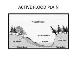
Dept. of Surveying and Land Administration The University of the West Indies, Trinidad Jacob Opadeyi, PhD Background • Flash flood is the most common causes of flooding in mountainous regions. • While it may be dry and sunny in the valleys and lower plains, there could be heavy torrential rain in the upper plains • Large amount of rainwater would rush down the river channel without any warning to those leaving in the lower plains.
Dept. of Surveying and Land Administration The University of the West Indies, Trinidad Jacob Opadeyi, PhD Objective of an EWS To empower individuals and communities threatened by hazards to act in sufficient time and in an appropriate manner so as to reduce the possibility of personal injury, loss of life and damage to property or the environment.
Dept. of Surveying and Land Administration The University of the West Indies, Trinidad Jacob Opadeyi, PhD Pre-requisite for an EWS Risk assessment: Flood hazard identification Flood hazard mapping Community vulnerability assessment
Dept. of Surveying and Land Administration The University of the West Indies, Trinidad Jacob Opadeyi, PhD Components of an EWS • Detecting and forecasting impending extreme events to formulate warnings on the basis of scientific knowledge and monitoring, consideration of factors that affect disaster severity and frequency. • Disseminating warning information, augmented by information of the possible impacts on people and infrastructure (i.e. vulnerability assessment), to the political authorities for further communication to the threatened population, including appropriate recommendations for urgent actions. • Responding to warnings, by the population at risk and local authorities, based on a proper understanding of the information, and subsequent implementation of protective measures.
Dept. of Surveying and Land Administration The University of the West Indies, Trinidad Jacob Opadeyi, PhD • A coherent set of linked operational responsibilities established • Be components of a broader programme of national hazard mitigation and vulnerability reduction. • Sole responsibility for the issuance of early warnings should be designated by the Government. • Authoritative decision makers with political responsibility for their decisions should be identified. • Action taken should be based on well-established disaster management procedures Principles for the application of early warning
Dept. of Surveying and Land Administration The University of the West Indies, Trinidad Jacob Opadeyi, PhD Principles for the application of early warning • Early warning systems must be based upon risk analysis that includes the assessment of the occurrence of hazards, the nature of their effects and prevailing types of vulnerability, at national and local levels of responsibility. • Need to monitor and forecast changes in vulnerability patterns, particularly at local levels, including those arising from social developments such as rapid urbanization, abrupt migration, economic changes, nearby civil conflict or similar elements.
Dept. of Surveying and Land Administration The University of the West Indies, Trinidad Jacob Opadeyi, PhD Principles for the application of early warning • To facilitate appropriate community actions, there is a need for detailed knowledge and experience of local factors and risks, decision-making procedures, roles and mandates of authorities, means of public communication and established coping strategies. • Locally appropriate warning systems need to provide a range of communication methods and to provoke multiple strategies for protection and risk reduction. • To be sustainable, all aspects of the design and implementation of early warning systems require the substantive involvement of stakeholders at the local and national levels.
Dept. of Surveying and Land Administration The University of the West Indies, Trinidad Jacob Opadeyi, PhD • Forecast timing and accuracy • Assessment of each stage of the warning process against specific targets such as proportion of audience reached and time taken to reach them • Quality of warning system design and operation • Public understanding of warnings • Human and economic losses avoided; • Knowledge and implementation of timely and appropriate actions • Public satisfaction with the warning service. Measure of effectiveness of an EWS
Community Flood Warning for Reventado in Costa Rica - Example of using the new water level gauge -
Rio reventado Taras, Los Diques Afectado x avalancha 1964 Costa Rica. Effects by avalanches. Area Reventado Watersheds and Los Diques Communities. Cartago. Reventado watershed. A big avalanche in 1964 related with volcanic deposits and different materials (ash & piroclast) combined with heavy rains.
Staff gauge for community flood warning Problem: Difficult to go to the sites under heavy rainfall and strong wind
Installation of water level gauge Costa Rica
ADVANTAGES • Cheap, easy O/M • Heavy rain is monitored even if it occurs in the midnight. • Presently, the gauge readers have to remain stand-by when alerted by weather forecast of possible heavy rainfall. But with this equipment, they are free until alarmed by buzzer/lamp.
Community Flood Warning for Speightstown in Barbados - Example of using the new rain gauge -
Barbados Meteorological Services (BMS) Flood Warning7:00 am Monday, November 22, 2004 Here is a Flood Warning from BMS. A persistent trough that has been in the area for the last few days produced moderate to heavy showers during the night. These conditions were expected to persist over the island today and with the saturated conditions of the ground any additional rain is likely to produce flooding in some areas. Residents in flood prone areas should be on the alert and take the necessary precautions. This warning will remain in effect until 4 pm today.
Dept. of Surveying and Land Administration The University of the West Indies, Trinidad Jacob Opadeyi, PhD • This phenomenon has led to loss of life and properties in many Caribbean communities • The questions:How can persons leaving in the lower plains be adequately informed of the impending flood water from the hill top? • What early warning system would give both the local residents and responsible public officials adequate notice to initiate evacuation? Problem Statements
Dept. of Surveying and Land Administration The University of the West Indies, Trinidad Jacob Opadeyi, PhD Components of the System
The buzzer sounds and the light turns on, and dials residents at the same time Whenever accumulated rain reaches pre-set levels, then,
Dept. of Surveying and Land Administration The University of the West Indies, Trinidad Jacob Opadeyi, PhD The Funnel • The funnel with the tube water collector should be installed in an open clear sky area free from rain drops from the house roof or surrounding trees • It should be protected from storming weather by fixing it to a strong plank
Cylindrical Water Collector • Collects & store rainwater that passes through the funnel. • Presently designed to hold 2050mm of rainfall • Contains 3 sensing rods • It should be installed inside of the house and away from usual household activities • The rainwater collected should be emptied daily
Sensing Rods • There are 3 sensing rods of different length from the sensing wire head • The length of the rods may be changed for different expected flooding threshold • As water level rises in the container, electrical connection is made when the water reaches any of the sensing rods • Once the connection is made, a signal in sent to the microprocessor.
EX. OF COMMUNITY OPERATED FLOOD WARNING Caparo river, Trinidad 10 year flood 50 year flood 5 year flood 2 year flood
Sensing Box The Sensing box comprise of the following: • Telephone dialing Keypad • Modem • Power supply system • Microprocessor
Sensing Box • The keypad is used to key in the phone number to be dialed by the system • The power supply provides the 110v electricity for the alarm and microprocessor • The modem is used to make phone calls to the designated number • The microprocessor is used to automate the actions of phone calls and alarm system.
Dept. of Surveying and Land Administration The University of the West Indies, Trinidad Jacob Opadeyi, PhD Features of the System • The system is capable of detecting 3 predefined rainfall levels. • The device generates an audible alarm based upon the changing rainwater levels. • The electronic of the system transmit alarm signals to a public or cell telephone using either landline or GSM network. • It is a stand alone system.
Dept. of Surveying and Land Administration The University of the West Indies, Trinidad Jacob Opadeyi, PhD Operations of the System • When it rains, rainwater drips into the cylindrical container through the funnel place outside of the monitoring station. • When the rainwater reaches any of the three pre-determined level, the system will self-dial a call to a phone to the alarm level using 3 different rates of tones. • The system will dial a user-configured number within 6” of any new level being crossed.
Dept. of Surveying and Land Administration The University of the West Indies, Trinidad Jacob Opadeyi, PhD • The unit will output a unique level-dependent audible beep pattern approximately 2 minutes after any level has been exceeded. The unit remains silent otherwise. • Calls are repeated every 5 mins • The unit identifies itself using caller-ID. • The phone number is stored in non-volatile system memory. • Currently operates ONLY with 115V AC. Operations of the System
Dept. of Surveying and Land Administration The University of the West Indies, Trinidad Jacob Opadeyi, PhD SystemRequirements • The device should be installed on a house or a remote monitoring station. • The station should have a direct phone line to be used for initiating calls • The station should be wired with 110V electric power with outlet for the system otherwise a 220-110 transformer is required • The landline or cell phone capable of receiving calls 24/7 within the community
ADVANTAGES • Cheap • Easy operate and maintained • Sudden increase in rainfall can be detected even if it occurs in the midnight; • Gauge readers no more need to go out to the gauging sites under the risky condition of wind storm, in the midnight etc.
Disadvantages Disadvantages: • System depend on AC power supply and landline telephone system
Conclusions • Support is needed to improve equipment for community flood warning and to test and evaluate the appropriateness to different conditions, and officially announce the result. • Manuals, guidelines etc. will be prepared to cover not only advanced technologies but also primitive ones so that governments and local groups may chose whatever most appropriate to their respective conditions, natural, social, human, financial etc.
Thanks For further information please contact: jopadeyi@eng.uwi.tt