Download
1 / 36
370 likes | 563 Vues
Modelling the Entire Great Lakes and the Ottawa River Watershed. Nick Kouwen Department of Civil Engineering University of Waterloo, Waterloo, ON ,Canada. http://www.watflood.ca. With a large amount of help from: Environment Canada Alain Pietroniro (Watershed setup)

E N D
Modelling the Entire Great Lakes and the Ottawa River Watershed Nick Kouwen Department of Civil Engineering University of Waterloo, Waterloo, ON ,Canada http://www.watflood.ca
With a large amount of help from: • Environment Canada • Alain Pietroniro (Watershed setup) • Pierre Pellerin (Synoptic & NWM data) • Champa Neal (Flow data)
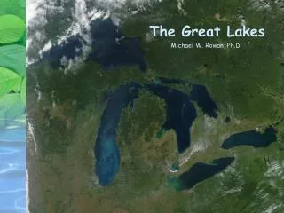
Geography Lesson Superior St. Mary’s R. Ottawa R. GB Michigan Huron St. Lawrence R. Ontario St. Clair R. Niagara R. Detroit R. Erie
WATFLOOD Features: • Primary application is flood forecasting and flood studies • Long time series for climate studies and frequency analysis • Ability to model regions from a few km2 to Millions of km2 • Automated watershed setup (ENSIM, MAPMAKER, TOPAZ) • Optimal use of gridded data • eg. Land cover, DEM’s, NWP model output, Radar data • Universally applicable parameter set • Fast • Very easy to use interface for routine work • Pick-up truck version
Highlights: • ENSIM – pre and post processor • Grouped Response Units GRU’s • Wetland model – coupled river-wetland hydraulics (also bank storage) • Tracer model – flow sourcing (glaciers, groundwater, wetlands, etc.) • There are many other useful features
EnsimHydrologic • Developed by the Canadian Hydraulics Centre CHC • Funded by Environment Canada
Start with a DEM S. Ontario in this case L. Huron Waterloo Toronto EnsimHydrologic work space L. Ontario
Delineate drainage & Watersheds automatically Specify WATFLOOD grid.
Zoom & edit data Extract WATFLOOD data
Elmira LANDSAT • 10 km grid (or whatever) • 100 km^2 area receives equal meteorological input • group all areas with similar hydrological characteristics within a grid for 6 hydrological computations/grid • some people model each pixel or each field separately - ok for science, not operations (10^4 computations/grid)
Group Response Unit - to deal with basin heterogeneity Physically Based Streamflow Routing
Percent Coniferous Forest Source: USGS GLOBAL LAND COVER CHARACTERISTICS DATA BASE
Percent Crops Source: USGS GLOBAL LAND COVER CHARACTERISTICS DATA BASE
Precipitation Evapotranspiration Interception Depression Storage Surface Runoff Wetting Front Unsaturated Zone Infiltration Wetlands Saturated Zone Interflow Base Flow Channel Flow Hydrological Modelling Model executed for each land cover GRU on each Grid each Hour
Previous experience: • Original model setup & calibration for the Grand River watershed in S. Ontario • Applications include: • Columbia River N. of US Border – 50,000 km2 • Mackenzie River ~ 1,7000,000 km2 • Rhone, Rhine, Po and Danube rivers as part of MAP (Mesoscale Alpine Project)
MAP (Fall 1999) Computed flows compared to observed flows for the Danube River in Germany & Austria Met data from the high resolution MC2 Numerical Weather Model MC2 & WATFLOOD ~3 km grid
Tracer Module Components Tracer 0 Baseflow separation Tracer 1 Sub-basin separation Tracer 2 Land-cover separation Tracer 3 Rain-on-stream tracer Tracer 4 Flow-type separation - surface - interflow - baseflow Tracer 5 Snow-melt as a fn(flow-type) - surface + surface melt - interflow + melt drainage - baseflow + interflow melt drainage Tracer 6 Glacial Melt - surface - interflow - baseflow
Model verification • E.G. Baseflow has been compared to isotope analysis of streamflow sources • All other model components have been similarly verified
Great Lakes & Ottawa River Model Meteorological Data: • 6 hour Synoptic data for initial setup for October 2000 – August 2003 • 3 hour GEM (Global Environmental Model) data for July & August 2003
Movie clip is an example of distributed Synoptic Data (Note the moving Bull’s eyes)
Next movie clip is for July 2003 using GEM data (GEM is Canada’s operational weather forcasting model)
Animation of Snow Cover (SWE in mm)
Animation of Grid Outflow
Computed hydrographs for 50 Sub-Watersheds 400-13500 km2
Lake Routing Superior St. Mary’s R. Ottawa R. GB Michigan Huron St. Lawrence R. Ontario St. Clair R. Niagara R. Detroit R. Erie
Lake Routing Rules (natural state): St. Marys River Q = 824.7*(SUP-181.43)^1.5 St. Clair River Q = 82.2*((MHU+STC)/2-166.98)^1.87*(MHU-STC)^0.36 Detroit River Q = 28.8*(STC-164.91)^2.28*(STC-ERI)^0.305 Niagara River Q = 558.3*(ERI-169.86)^1.60 St. Lawrence River Q =555.823*(Oswego-0.0014(Year-1985)-69.474)^1.5
Needs work. Ave. lake levels are ok. Variation is inadequate. Effect of weeds, ice & operations not yet incorporated.
Summary • Great tools are required to model large areas such as the Great Lakes & Ottawa River basin. • Pre-processor – set up watershed files • Post-processor – debugging & visualization • GRU’s ensure vastly different hydrological units are represented appropriately at the large scale • Gridded model • Efficient ingestion of gridded data: DEM, Land cover, meteorological data (radar, numerical weather models) Much tweaking to be done!