Download
1 / 70
700 likes | 860 Vues
June 2005 Upgrade Package for High Resolution Window (HRW) Decision Brief. Mesoscale Modeling Branch Geoff DiMego, Eric Rogers and Matt Pyle 24 June 2005. where the nation’s climate and weather services begin. June 2005 Upgrade Package Background – Original Plan.

E N D
June 2005 Upgrade Package forHigh Resolution Window (HRW)Decision Brief Mesoscale Modeling Branch Geoff DiMego, Eric Rogers and Matt Pyle 24 June 2005 where the nation’s climate and weather services begin
June 2005 Upgrade PackageBackground – Original Plan Original AOP Milestone was to add 4 more WRF runs to the HiResWindow slot: Add to existing two control runs of WRF-ARW (10km/50 level) and WRF-NMM (8km/60 level) Two pairs of runs added based on a breeding-cycle for each control run making total of 6 There was no room to do this in Q4 2004 because of delays in CCS upgrade availability Hurricane runs would supercede just these 4 HRW bred-mode runs but not the two controls which would always run
June 2005 Upgrade PackageBackground – What Changed Success of three recent experiments using explicit (4-5 km) configurations of the WRF model with no convective parameterizations BAMEX 2003 SPC/NSSL Spring Program 2004 & 2005 DTC Winter Forecast Experiment 2005 Abrupt loss of critical scientist working on the WRF ensemble breeding cycle 2005 implementations of T-382 and GFDL Hurricane model leave no room for two control runs to run when there are four hurricane runs being made
June 2005 Upgrade PackageThe New Plan Push full limits of computer resource in HRW slot to achieve maximum resolution WRF-ARW: from 10km/50lev to 5.8km/35lev WRF-NMM: from 8km/60lev to 5.1km/35lev Not ideal but sufficient to turn-off calls to convective parameterizations (see next slide) Ferrier cloud & microphysics run in both No immediate change to output grid resolution WRF Ensemble still to be delivered Q4 2005 with 6 WRF members added to SREF
Bill Gallus’ DTC Work • Even though new HRW WRF runs are at 5.1/5.8 km resolution, we will turn off calls to parameterized convection. • Bill Gallus successfully ran explicit 4, 6, 8 and even 10 km runs with ARW on some heavy August 2002 MCC cases during his summer 2003 stint at the DTC.
June 2005 Upgrade PackageValidation of New Plan NCEP Director was briefed 27 May and a “vetting of the plan” was requested EMC polled NWS Regions & NCEP Service Centers concerning new plan Responses received were all positive: NCEP: AWC, HPC, SPC TPC, CPC don’t really use but had no objections NWS: CR, WR, SR (ER & CR were evaluators)
HiResWindowFixed-Domain Nested Runs21 Sept 2004 Became WRF Runs of Two Control ConfigurationsWRF-ARW at 10km/50levels and WRF-NMM at 8km/60levels • FOUR routine runs made at the same time every day • 00Z : Alaska & Hawaii • 06Z : Western & Puerto Rico • 12Z : Central & Hawaii • 18Z : Eastern & Puerto Rico • Everyone gets daily high resolution runs of both WRF controls if & only if GFDL hurricane runs are not needed http://www.emc.ncep.noaa.gov/mmb/mmbpll/nestpage/Alaska domain is smaller than depicted
HiResWindowFixed-Domain Nested Runs28 June 2005 Become Explicit WRF Runs of Two Control ConfigsWRF-ARW at 5.8km/35levels and WRF-NMM at 5.1km/35levels • FOUR routine runs made at the same time every day • 00Z : Alaska & Hawaii • 06Z : Western & Puerto Rico • 12Z : Central & Hawaii • 18Z : Eastern & Puerto Rico • Everyone gets daily high resolution runs of both WRF controls if & only if GFDL hurricane runs are not needed http://www.emc.ncep.noaa.gov/mmb/mmbpll/nestpage/Alaska domain is smaller than depicted
Prior Experience: BAMEX Bow Echo and MCV Experiment Ran WRF-ARW only
Prior Experience: SPC/NSSL Spring Program 2004 • EMC made special WRF-NMM Runs Beginning in April 2004, EMC ran: • 4.5 km version of its WRF-NMM • Without calls to parameterized convection • Initialized off 12 km Eta (at 40 km resolution) • Daily runs to 30 hours from 00z • Central/Eastern US domain • SPC requested that this run be continued as long as possible – and its still running!
Domains of Integration for Spring ProgramNCEP NMM (red/orange),NCAR (blue),CAPS (cyan) 2005 2004
Example of Explicit 4.5 km WRF-NMMcourtesy of Jack Kain WRF 24 hour 4.5 km forecast of 1 hour accumulated precipitation valid at 00Z April 21, 2004 (better than 12 hour forecasts by operational models) 4.5 km WRF-NMM Verifying 2 km radar reflectivity
HiResWindow WRF Runs vs Eta Current HRW components
4km WRF Runs vs 12km Eta Similar to new HRW components
Matt Pyle’s Web Site Displaying 4.5 km WRF-NMM http://www.emc.ncep.noaa.gov/mmb/mmbpll/cent4km/ 30 hour forecast valid 06z 7 December, 2004
Web Site Now Displaying Simulated Reflectivity 12 hour forecast valid 12z 22 June, 2005
Prior Experience: DTC Winter Forecast Experiment • Cold season (Jan-Mar 2005) runs • Both cores/controls run between NCAR & FSL • 5 km resolution over full CONUS domain • Explicit configuration with no parameterized convection • Forecast fields distributed to NWS offices via FXNet • Full verification against observations & gages
Interactions between DTC and NWS • FSL ran WRF-NMM and NCAR ran WRF-ARW • Both models initialized at 00 UTC from EDAS and made 48h forecasts • NWS participation in DWFE design, evaluation, and reporting • Eastern, Southern, Central regions of NWS, some NWS/WR offices • Hydrometeorological Prediction Center • Display of model forecast products • FX-Net, DTC website, and two-dimensional AWIPS displays • VisitVIEW training on WRF and DWFE presented to NWS at outset • Researchers and forecasters learning together how to use this fine-scale information and what model products are of greatest use 19
Examples of Phenomena Forecast by DWFE WRF Modelsfrom a presentation made by Steve Koch to OAR FSL also made available on its FX-Net system the ability to display the 8-10 km High-Resolution Window (HRW) domain WRF model runs from NCEP
ARW 3-h forecast Composite Reflectivity Lake-effect snowbands Lake-effect snowbands Narrow Cold-Frontal Rainband Narrow Cold-Frontal Rainband 0600 UTC Radar Mosaic Observed Composite Reflectivity at 03Z Narrow Reflectivity Bands:23 January 2005 21
Topographically forced Pressure Waves and Snowbands in New England Blizzard: 23 January 2005 WRF-ARW 00Z 22Jan05 F27 Verifying 5-km Surface Mesoanalysis for 0300 UTC 995 988 22
Reflectivity Structures in Marine Boundary Layer: 23 January 2005 Cloud Streets Marine Stratus Mesoscale Cellular Convection 23
Mesoscale vortex over Lake Erie:22 January 2005 ARW-5 18h Forecast for 1800 UTC 22Jan05 STMAS Analysis for 1900 UTC 22Jan05
DC Metro Snowstorm Bust:27-28 February 2005A comparison between two WRF forecasts made 24h apart demonstrating that the synoptic-scale must be forecast correctly as a necessary condition to predicting mesoscale structures accurately 25
WRF-NMM 42h Forecast of Mean Sea Level Pressure and 3-hour Accumulated Precipitation for 1800 UTC 28Feb05 shows strongly banded precipitation over Maryland and strong surface cyclone incorrectly positioned over southern Delmarva
WRF-NMM 18h Forecast of Mean Sea Level Pressure and 3-hour Accumulated Precipitation for 1800 UTC 28Feb05 shows disorganized precipitation over Maryland and weaker surface cyclone correctly positioned east of Hatteras
Comparison of NCEP and RTVS methods for calculating ETS & Bias95% confidence intervals using bootstrapping method are shown
Allowed forecasters to gain experience using high-resolution WRF model output over a large domain in an operational fashion AWIPS and FX-Net display capabilities Novel radar reflectivity product First time presented for winter weather Useful for real-time verification against radar data Made visualization of mesoscale features easier The ability to forecast mesoscale structures Lake effect snow bands and other bands Interaction of winter systems with terrain Details offered HPC “tremendous advantage” over operational QPF Predicted timing and placement of snowbands Conflicts with IFPS during active weather Only one run per day and 48h forecast too short a duration (limiting factors at HPC and for populating 5-km NDFD grids) Overprediction of orographic snowfall and in regions of instability (e.g., cold air outbreaks over Gulf Stream) WRF models tend to forecast features similar in appearance to (but with much greater detail than) the Eta model, to which they are slaved Global model forecast errors feed directly into errors in forecasts of fine-scale details in WRF models after a few hours Multi-scale display of upper-level fields? DWFE Forecaster FeedbackPluses Minuses
NCEP’s Explicit WRF HiResWindow Evaluation • Parallel set of runs made for the four large HRW domains • Parallel runs were made in near real-time • Parallel runs were made reliably by NCO on Production side of CCS • EMC turned over codes with final configuration to NCO in late May • EMC produced extensive webpage showing comparisons of 5 km runs with existing runs
http://wwwt.emc.ncep.noaa.gov/mmb/mmbpll/hiresw5km.east08/index.htmlhttp://wwwt.emc.ncep.noaa.gov/mmb/mmbpll/hiresw5km.east08/index.html
Forecast Examples From Evaluation Period:Shelter Temperature10 m WindQPF
8 km NMM 5 km NMM 8 km NMM forecast of 24-28C too warm
10 km ARW 5 km ARW Both ARW runs too warm
8 km NMM 5 km NMM 8 km NMM forecast of 40-44C too warm 5 km NMM much closer
10 km ARW 5 km ARW Neither ARW too bad near Phoenix
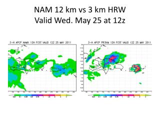
5km QPF Comparison Plot Heavier showers in NMM5 than in EM5
“Big Picture” 5km Sfc Winds Comparisoncan’t see anything really meaningful
Local 5km Sfc Winds Comparison Plot Outflow beneath heavy showers approaching Lake Michigan
Local 5km Sfc Winds Comparison Plot Outflow beneath heavy showers approaching Lake Niagara
“Local” 5km Sfc Winds Comparison Plot Outflow beneath heavy showers in central New York state
8 km operational WRF-NMM BMJ produces broad, smooth precipitation patterns in the current HRW 3 h precipitation total (in.)