Download
1 / 27
270 likes | 303 Vues
This document provides an overview of the HRW product content, algorithms, implementation issues, and examples. It covers steps like image pre-processing, tracers, guess (NWP), level assignment, tracking, flagging, and selection. Examples include different conditions, cloudiness, and known problems.

E N D
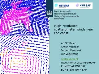
HRWHigh Resolution Winds 15th June 2004 Madrid José Miguel Fernández-Serdán ST - STAP / INM
Summary HRW product content. Algorithms overview. Relevant implementation issues in PGE09. Examples for different conditions or cloudiness. Some known problems. Options not in the default configuration. Further development work.
HRW product content In form of BUFR bulletins (observations like): • Basic data: Latitudes and longitudes ( at t-Δt slot, increment t-Δt to t). Temperature (K) and pressure level(hPa) for the tracer. Wind direction (degrees) and speed (mps). Quality indicator (QI, %). • Additional data: Time increment (Δt). Tracer size (= best average resolution) (km). Recommended quality threshold (set to 60%). Processing indicators (tracer, tracking, level, guess, q.c. steps) (*).
Algorithms overview Steps: Image pre-processing. Tracers. Guess (NWP)(*). Level assignment. Tracking. Flagging. And Selection.
Algorithms: Image pre-processing • A Region of the HRV channel is processed (*). (channel most indicated to nowcasting applications). • Raw data are “normalised” ( division by cos-z, z is the sun- zenith angle). (allow using fixed threshold value). • Range of brightness reduced to values in range 0-255 (8 bits). (MOP/MTP heritage, but also because quite low contrasts not much desired at tracking).
Algorithms: Image pre-processing HRV brightness HRV brightness, normalised
Algorithms: Tracers 2 methods: • Gradient:search of well defined cloud edges. (well proven, good, fast). • Tracer characteristics: to fill “holes” in coverage. Around each “candidate tracer” location, checks for: • A threshold clearly separating “bright” vs. “no bright” pixels. (the cloudiness or clear part of it, in front of a “background”). • A rough distribution of “bright” pixels showing a “well defined” shape. (e.g. avoid “too linear” cloudy elements). • And not much scatter in IR-channel temperatures for “bright”. (avoid multilevel cloudiness) (**).
Algorithms: Guess (NWP) NWP input is (by now) mandatory . • p-T fields interpolated to centre of each tracer: level assignment. • p-(u,v) fields interpolated to centre and level of each tracer: reduce tracking area. (full tracking could be too time consuming, nevertheless: guess dependence kept marginal). Also needed at the flagging step (partial guess QI). • SAFNWC NWCLIB routines are used (*).
Algorithms: Tracers level • The basic input is: mean IR10.8-channel temperature for “bright” pixels (provided by the tracer-characteristics method), converted to pressure. (these pixels considered as a significant part of the cloudy pixels being tracked). • A “cloud base” is extrapolated for low levels >700hPa (*). (low level winds known as close to wind at cloud-base level). • A “cloud top” is preferred for high levels <400hPa (the coldest pixels). • Note: IR-channel at 3km vs. HRV at 1km, Ci cloudiness less transparent IR than VIS (**).
Algorithms: Tracking • The tracers (selected square segments, HRV region, t-Δt slot) are matched to tracking candidates (same size segments at t-slot, until a “reasonable” search distance) by 2 methods: Summed squared difference:used for “big” tracers (basic processing, basic scale). (faster matching). Cross correlation: for “small” tracers (additional processing for the fine scale). (more effective matching). • The best match and up to 2 other tracking centres, are kept: up to 3 candidate-winds per tracer. (to then perform a final selection step)
Algorithms: Tracking First image Second image
Algorithms: Flagging • Use of Quality Indicators method (QI, Holmund 1998, used at EUMETSAT, adapted in several aspects to HRW) (*). (method well known and quite efficient). • Normalised tests on consistency are (if possible) computed: • In space (comparison to neighbours t-slot winds, an independent 2 scales spatial test is possible for some fine-scale winds) (**). • In time (comparison to a close wind in the t-Δt slot set of HRW results). • To forecast (NWP). • The final QI is the weighted sum of partial QIs. Given not all test is possible for any wind, an indicator “tests passed” is also added to the QI (***).
Algorithms: ... And Selection • Up to 3 winds per tracer were tracked and flagged, only one wind per traceris kept for output in the HRW bulletin (BUFR code). (implies less information but more straightforward to use). • The (default) way of selecting is: to keep the best at most selection criteria (up to 6): • Best matching. • Less change in tracer characteristics. • And the best at each partial QIs (up to 4). • If not yet decisive: the one (significantly) more consistent when compared to the guess. Or the best tracking.
Relevant implementation issues in PGE09 • A 2-scales procedure (default): • 24px coarse scale and 12px fine scale (*). • Most of the procedure is performed twice, similar (**). • Search of fine-scale tracers: where no coarse scale tracer found, or it is “wide” (***). • “Inter-scale” spatial consistency test tried for fine-scale winds in the case of “wide”. (fine-scale complementary to coarse: where no coarse, or it suggests more detail in wind field can be reached). • The HRW output composed of 2 datasets (BUFR bulletins): Basic winds: coarse-scale winds (SAFNWC_..._B.buf ). Detailed winds: fine-scale winds, plus coarse non wide-tracer winds (^) (SAFNWC _..._D.buf. (“secure” vs. “dense” wind datasets) . • Tracers step is implemented as the final step (t-slot preprocessing for t + Δt HRW winds).
Examples for different conditions or cloudiness Lee cloud conditions. Convection at different stages of development. Cloudiness related to small-scale circulation. Low sun elevation. Slant satellite viewing angle. Frontal systems (including semi-transparent Ci). Display: QI > 59% :>700hPa.700-400hPa.<400hPa. (QI 50-59%)
Examples: Lee cloud conditions(23/03/04 at 7:00 and 10:00 UTC) Detailed winds
Examples: Convection at different stages of development (01/06/04 at 15:00) Basic winds Detailed winds
Examples: Cloudiness related to small-scale circulation (07/06/04 7:45 to 8:30) VIS0.6 IR10.8 Detailed winds Basic winds
Examples: Slant satellite viewing angle(14 to 16/10/03 at 10:00 UTC) Basic 14 15 16 Detailed
Examples: Frontal systems (including Ci) (16/04/04 at 7:15 UTC)
Some known problems • “Ground tracers” (most evident in case of snow). Others: ground-influenced cloudiness. • The “high” normalised threshold requested (same land and sea) misses some low-level cloudiness not bright enough to give tracers (e.g. many Sc, could also present large extensions of little contrast). • The HRW detailed wind pattern still not as “high resolution” as could be desired (e.g. fields of small Cu likely giving few tracers with the described methods). Also, more often than in the case of basic winds, erroneous detailed winds reach a QI of 60%. • A fixed QI reference threshold (60%) (despite the disparity in processing conditions, and applied QI tests, etc.) (*). • The level-assignment based on IR information. • (HRV mis-registration image to image: not yet clear cause of error since MSG data operational).
Options not in the default configuration • Wind continuity: • Tracers step: at each location, first looks close (in position, level, at same scale and same tracer method) to final location of any wind t-Δt: “persistent tracer”. Otherwise tries for a new tracer. • Time consistency QI tests: only for persistent tracers. (time consistency closer to EUMETSAT’s symmetry test; provides sometracers’ trajectories and durations). • But: time consuming (more new tracers than expected): a sub-region for the fine-scale is advised in this option. • Single-scale procedure (similar to coarse-only, at 20 pixel resolution or better): (a compromise, and faster, but gives “less complete” results). • Wind selection on best QI (space&time) (PGE09 v0.0) (*).
Options not in the default: Persistent tracers Using Continuity option Basic winds dataset, 26/03/04 Using Default
Further development work (*) • Addition of a terrain-influence flag (Fernández, 2003)(**), identifying: • Possibly non-cloud tracer (just land feature) (but also: plans to use cloud-top product CTTH) • Tracer possibly blocked by terrain (could perhaps give non realistic winds) • Tracer likely in presence of gravity wave conditions (could give non realistic wind) • New work (2004): • Improvement of lee-wave conditions flagging (avoid fixed vertical lapse- rate and –maybe- fixed distance to obstacle). • Use of terrain-influence flag in wind selection. • Use of CTTH, as option for level-assignment.