Download
1 / 34
350 likes | 394 Vues
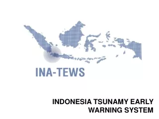
Learn about Indonesia's BMG's responsibilities & the concept of InaTEWS, components, dissemination methods, challenges, and solutions for establishing an efficient early warning system. Explore coordination roles and the need for direct links, uniformity, and 24/7 operations.

E N D
BMG stands for (Badan Meteorologi dan Geofisika) METEOROLOGICAL AND GEOPHYSICAL AGENCY • By law is the appointed official agency in Indonesia in charge for Tsunami Warning Dissemination.
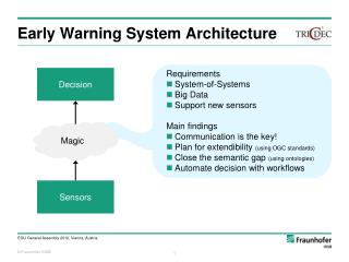
Components of TEWS: observation, integration, dissemination & community preparedness
1 2 3 END TO half-END CONCEPT OF Indonesian TEWS (InaTEWS) BMG OBSERVATION PROCESSING DISSEMINATION • Seismograph • accelerograph Evacuate Watch Advisory Cancellation Earthquake Information • Time • - Location • - Magnitude Communication Banda Aceh Siren Decision support Manual Verification Speaker Earthquake information or Tsunami Warning Padang Denpasar Phone/fax BMG HQ Jakarta SMS Epicenter SMS 5 in 1 Phone Web Email Control System Of Situation Center • Tide Gauge • Buoy/OBU • GPS LAND STATION • Earth Observation Control System Of Situation Center Communication
BMG Terestrial Line Radio Link FM RDS Satelite Comm/GSM SIREN Fiber Optic & Sat. Comm. DISSEMINATION SYSTEM INTERFACE INSTITUTIONS PROV. POLICE DISTRICT POLICE NAT’L POLICE DEPT. OF COMM. & INFO TECH TV ; RADIO DEPT. OF HOME AFFAIR PROV. GOV. DISTRICT GOV BMG Earthquake Inform. & Tsunami Warning BAKORNAS PB REGIONAL SEISMIC CENTER (RSC) COMMUNITY FM RDS / R A N E T ?
5in1 BMG INFO BMG Interface Institution INTERNET/DEDIC LINE BMG sms TXT & XML File fax alarm web voice
THEORITICALLY IT LOOKS OKAY but in the reality we faced problems • Roles and Responsibilities of the institutions are not yet clear • Limited Budget and Lack of Implementing Commitment • Limited Human Resources and Technology • Unstable Network Connections • No guarantee the Warning System can reach the vulnarable areas
BMG Terestrial Line Radio Link FM RDS Satelite Comm/GSM SIREN Fiber Optic & Sat. Comm. DISSEMINATION SYSTEM INTERFACE INSTITUTIONS PROV. POLICE DISTRICT POLICE NAT’L POLICE DEPT. OF COMM. & INFO TECH TV ; RADIO DEPT. OF HOME AFFAIR PROV. GOV. DISTRICT GOV BMG Earthquake Inform. & Tsunami Warning BAKORNAS PB REGIONAL SEISMIC CENTER (RSC) COMMUNITY R A N E T ?
BMG Terestrial Line INTERFACE INSTITUTIONS PROV. POLICE DISTRICT POLICE NAT’L POLICE DEPT. OF COMM. & INFO TECH TV ; RADIO Radio Link FM RDS DEPT. OF HOME AFFAIR PROV. GOV. DISTRICT GOV BMG Earthquake Inform. & Tsunami Warning Satelite Comm/GSM SIREN BAKORNAS PB REGIONAL SEISMIC CENTER (RSC) Fiber Optic & Sat. Comm. COMMUNITY R A N E T ? DISSEMINATION SYSTEM Who is responsible for Coordination?
BMG Terestrial Line INTERFACE INSTITUTIONS PROV. POLICE DISTRICT POLICE NAT’L POLICE DEPT. OF COMM. & INFO TECH TV ; RADIO Radio Link FM RDS DEPT. OF HOME AFFAIR PROV. GOV. DISTRICT GOV BMG Earthquake Inform. & Tsunami Warning Satelite Comm/GSM SIREN BAKORNAS PB REGIONAL SEISMIC CENTER (RSC) Fiber Optic & Sat. Comm. COMMUNITY R A N E T ? DISSEMINATION SYSTEM Who is responsible for Coordination? Direct Link!
BMG Terestrial Line INTERFACE INSTITUTIONS PROV. POLICE DISTRICT POLICE NAT’L POLICE DEPT. OF COMM. & INFO TECH TV ; RADIO Radio Link FM RDS DEPT. OF HOME AFFAIR PROV. GOV. DISTRICT GOV BMG Earthquake Inform. & Tsunami Warning Satelite Comm/GSM SIREN BAKORNAS PB REGIONAL SEISMIC CENTER (RSC) Fiber Optic & Sat. Comm. COMMUNITY R A N E T ? DISSEMINATION SYSTEM Who is responsible for Coordination? Direct Link! Define 24/7!
BMG Terestrial Line INTERFACE INSTITUTIONS PROV. POLICE DISTRICT POLICE NAT’L POLICE DEPT. OF COMM. & INFO TECH TV ; RADIO Radio Link FM RDS DEPT. OF HOME AFFAIR PROV. GOV. DISTRICT GOV BMG Earthquake Inform. & Tsunami Warning Satelite Comm/GSM SIREN BAKORNAS PB REGIONAL SEISMIC CENTER (RSC) Fiber Optic & Sat. Comm. COMMUNITY R A N E T ? DISSEMINATION SYSTEM Who is responsible for Coordination? Uniformity of messages! Direct Link! Define 24/7!
BMG Terestrial Line INTERFACE INSTITUTIONS PROV. POLICE DISTRICT POLICE NAT’L POLICE DEPT. OF COMM. & INFO TECH TV ; RADIO Radio Link FM RDS DEPT. OF HOME AFFAIR PROV. GOV. DISTRICT GOV BMG Earthquake Inform. & Tsunami Warning Satelite Comm/GSM SIREN BAKORNAS PB REGIONAL SEISMIC CENTER (RSC) Fiber Optic & Sat. Comm. COMMUNITY R A N E T ? DISSEMINATION SYSTEM Who is responsible for Coordination? Uniformity of messages! Direct Link! Define 24/7!
SUMMARY • Set up a direct link from Sources to the closest institution to the local communities and public • Setup a 24x7 “Watchdog” Warning Center • Find the fastest way to reach the community • Mosques, Radio, Sirene • Produce an SOP for Warning Dissemination (valid for everyone) • Produce a LAW to make sure that the SOP is followed and to have the Uniformity.
ESTABLISHMENT OF TSUNAMI WARNING SYSTEMIN PADANG CITY WARNING CENTER
Earthquake Epicenters (Engdahl 1964-2006 M>5) PADANG YOGYA BALI Seismic gaps
1941 (7.9) Sumatran fault Zone Plate movement 50 – 60 mm/year 2004 (M9.15) EURASIANPLATE 1881 (7.9) 2002 PADANG 1907 (~M7.8) Malaysia 1861 (M~8.5) 2005 (M 8.7) Currently locked, Near end of cycle section 1935 (M7.7) 1797 (M8.4) 1833 (8.9) Jakarta 2000 (M7.8) Un known section, No large eartquakes in Historical records INDIAN-AUSTRALIAN PLATE
Tsunami Risk Map - National Geographic Indonesia March Edition - 2005 Padang
GENERAL INFORMATION Padang is a capital of West Sumatera Province. Almost 1 million people live in the CIty. Geographically, it lays on the west coast of Sumatra Island and has a direct border with the open sea (Indian Ocean)
BACKGROUND The Tsunami incidents in Aceh, Nias and series of Earthquakes in Sumatra Islands has woken up the Local Authorities and the People of Padang. They are starting to realize that they live in vulnarable area.
TOPOGRAPHY MAP OF PADANG CITY : 0-5 M : 5 – 10 M : 10 – 25 M : 25 – 100 M : > 100 M
Something has to be done ! • What ? • Who ? • How ? • Where to start ? • …………..??????
MAYOR District Army District Police Chairman Vice Chairman Vice Chairman ORGANISATION STUCTURE OF PUSDALOPS SATLAK / WARNING CENTER WARNING CENTER CHIEF Administration Finance Group 1 Group 2 Group 3 EVAC & SARi INFRASTRUCTURE HEALTH & LOGISTIC 24 x 7 STAND BY
Pusdalops as the Coordinator of Dissaster Management and Warning Dissemination CHIEF GROUP 1 GROUP 2 GROUP 3 Evac & SAR Infrastructure Health & Logistics • Police • Military • Red Cross • SAR Team • Fire Brigade • Tsunami Comm. • Scouts • Radio & TV • Amateur Radio • NGOs • Medic Teams • Electricity Company • Public Water Works • Dept. Of Infrastructure • Miltary & Police • Telecommunication • Local Government • NGOs • Health Dept. • Read Cross • Hospitals • Dolog • Social Dept • NGO’s The Chief of Pusdalops have authority by law to call or to activate the group
Existing Condition of Pusdalops Padang City • Pusdalops Office has already established at Fire Brigade Department • Personal Computers • Speedy Internet Connection • Radio Communication System • VHF Repeater System – Motorola • 1 HF Radio Vertec System • 1 VHF Radio • 24 x 7 Stand By Personnel
Alerting the Public – How? • The key is to educate and communicatea warning message to people on the coast to move inland to higher ground to escape the destructive waves. Also consider vertical evacuation in reinforced concrete buildings. • All organizations need to develop Standard Operating Procedures and multiple communication methods for alerting the public, using high and low technology such from satellite broadcasts to mosques loudspeakers to communicate the alert. • Special Case: Local Tsunami. First Line of Defense - Public awareness and education will save people near earthquake epicenter.
There is no dissemination system that is best for all communities: Different communities have distinct characteristics and needs. Factors to consider: Size and layout of the area Composition and activities of the population Financial resources of the community Existing notification systems Local dissemination: what’s the best?
Examples of Notification Systems • Use of Mass Media (Radio, Television) • Siren Towers • First Responders (i.e. Police, Fire, Lifeguards) • Public Loudspeakers (Mosques) • SMS Text Messaging – Telephone Companies • Emergency Telephone Call Lists (public and private sectors) • RAPI (Indonesian Citizen Band) • Police & Military Resources • RANET • FM RDS
WARNING CHAIN IN PADANG COMMUNITIES / PUBLIC Siren Activation BMG FM RDS Mosques Schools Public Facilities RANET PUSDALOPS VHF SMS/PHONE Working Group I – II - III TV & RADIO RRI FM RDS FM RDS
Existing Agendas of Local Govt. of Padang • Finalization of Peraturan Daerah (Perda) • Finalization of SOP (Protap) • Establishment of PUSDALOP • Local Curricullum • Evacuation Routes and Signs • Zoning dan building Regulation. • Socialization, Dissemination and Drills • Connection to the National and Provincial Programs • Readiness • Supports and Backup from other parties On Progress Source: Pemko Padang
THANK YOU! Thailand, 5-8 Februari 2007 – Chonlapreuk Resortr, Nakorn Nayok aimzein@fastmail.fm