HPC - NAME
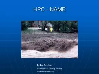
HPC - NAME. Mike Bodner Development Training Branch mike.bodner@noaa.gov. Excessive Rainfall. What is Excessive Rainfall? Rainfall heavy enough to cause excessive runoff or flooding How do we produce an Excessive Rainfall Forecast?


HPC - NAME
E N D
Presentation Transcript
HPC - NAME Mike Bodner Development Training Branch mike.bodner@noaa.gov
Excessive Rainfall What is Excessive Rainfall? Rainfall heavy enough to cause excessive runoff or flooding How do we produce an Excessive Rainfall Forecast? Based on expected short-term rainfall and RFC computed flash flood guidance issued each day One & three hour FFG We don’t use 6, 12 or 24 hour guidance
HPC Text Discussions • Model Diagnostic • Day 1-3 QPF • Excessive Rainfall
National Precipitation Prediction Unit (NPPU)HPC and SAB Working Relationship • Satellite Analysis Branch (SAB) of NESDIS is co-located with HPC • The SAB precipitation meteorologists provide 6 regularly scheduled satellite briefings per day to HPC QPF forecasters
SAB Products • Satellite precipitation estimates • Guidance for heavy rain and snow associated with winter storms • Satellite precipitation estimate message (SPENES) ►GOES infrared (IR), visible, and water vapor imagery ►GOES Sounder data and Derived Product Imagery ►GOES satellite-derived winds ►Special Sensor Microwave Imager (SSM/I) ►NOAA Advanced Microwave Sounder Unit (AMSU) ►Surface and upper air data