Challenges
This study explores the use of operational satellite sounders, such as AIRS and CrIS, to derive atmospheric concentrations of greenhouse gases. The aim is to reduce uncertainty in climate projections by improving our understanding of greenhouse gas sources, transport, and climate feedbacks. By comparing satellite retrievals with ground-based measurements, we assess the reliability of these tools for climate analysis, particularly in regions lacking robust data. Such advancements can significantly enhance decision-making in both public and private sectors concerning climate actions.

Challenges
E N D
Presentation Transcript
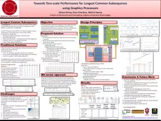
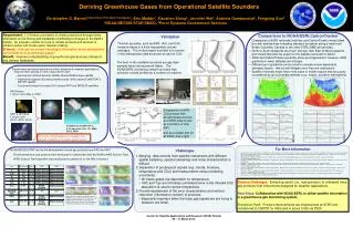
Deriving Greenhouse Gases from Operational Satellite Sounders Christopher D. Barnet1(Government Principal Investigator), Eric Maddy2, Xiaozhen Xiong2, Jennifer Wei2, Antonia Gambacorta2, Fengying Sun2 1NOAA/NESDIS/STAR/SMCD, 2Perot Systems Government Services Requirement: (1) Reduce uncertainty in climate projections through timely information on the forcing and feedbacks contributing to changes in the Earth’s climate. (2) Increase number and use of climate products and services to enhance public and private sector decision making. Science:How can we extract meaningful information about atmospheric concentrations of greenhouse gases? Benefit: Improve understanding of greenhouse gas sources, transport, and climate feedbacks. Comparison to NOAA/ESRLCarbonTracker Validation • Comparison of AIRS retrievals (red line) and CarbonTracker model (dark line with dashed lines indicating standard deviation) along a track from British Columbia, Canada to two other ESRL/GMD aircraft sites. • North to South Gradients are much stronger than East to West gradients and should therefore be easier for the satellite retrievals to detect. • AIRS and CarbonTracker generally show good agreement; however, AIRS gradients in lower latitudes are stronger. • Differences in gradients can be used to evaluate scene dependent (airmass) biases - that we will mitigate once they are understood. • Satellite retrievals might have more value in model regions that are poorly constrained by ground measurements (e.g., tropics, southern hemisphere) Thermal sounders, such as AIRS, IASI, and CrIS, measure traces in a thick tropospheric column averages. The vertical region sounded is a function of the atmospheric state as shown at right for CO2 The best in-situ validation products are gas flask samples taken during aircraft flights. The NOAA/ESRL monitoring network provides high precision vertical profiles for a number of locations • Exploit advanced hyper-spectral sounders, designed for weather applications, that are either already in-orbit or planned for orbit: • Atmospheric Infrared Sounder (AIRS) aboard NASA’s Aqua satellite • Infrared Atmospheric Sounding Interferometer (IASI) aboard EUMETSAT’s METOP satellite • Cross-track Inrared Sounder (CrIS) aboard NPP and NPOESS satellites Comparison of AIRS CO2 product with aircraft measurements at 4 ESRL sites shown as a function of time (left) and as a scatter plot for all ESRL sites (right) For More Information Divakarla, M., C. Barnet, M. Goldberg, E. Maddy, B. Irion, W. Newchurch, X. Liu, W. Wolf, L. Flynn, G. Labow, X. Xiong, J. Wei and L. Zhou 2008. Evaluation of Atmospheric Infrared Sounder (AIRS) Ozone Profiles and Total Ozone Retrievals with Matched Ozonesonde Measurements, ECMWF Ozone Data, and Ozone Monitoring Instrument (OMI) Retrievals. J. Geophys. Res. v.113 D15308 doi:10.1029/2007JD009317, 24 pgs. Gambacorta, A., C.D. Barnet, B. Soden and L. Strow 2008. An assessment of the tropical humidity-temperature covariance using AIRS. Geophys. Res. Lett. v.35 L10814 doi:10.1029/2008GL033805, 5 pgs. Maddy, E.S., C.D. Barnet and A. Gambacorta 2009. A computationally efficient retrieval algorithm for hyperspectral sounders incorporating a priori information. IEEE Geosci. Remote Sens. Letters v.6 p.802-806. Maddy, E.S. and C.D. Barnet 2008. Vertical resolution estimates in Version 5 of AIRS operational retrievals. IEEE Trans. Geosci. Remote Sens. v.46 p.2375-2384. Maddy, E.S., C.D. Barnet, M. Goldberg, C. Sweeney and X. Liu 2008. CO2 retrievals from the Atmospheric Infrared Sounder: Methodology and Validation. J. Geophys. Res. v.113 D11301 doi:10.1029/2007JD009402, 7 pgs. Xiong, X., S. Houweling, J. Wei, E. Maddy, F. Sun and C. Barnet 2009. Methane Plume over South Asia during the monsoon season: satellite observation and model simulation. Atmos. Chem. Phys. v.9 p.783-794. Xiong, X., C. Barnet, E. Maddy, X. Liu and M. Goldberg 2008. Variation of Atmospheric Methane over the Permafrost Regions from Satellite Observation during 2003 to 2007. International conference of Permafrost v.9 p.1981-1986. Xiong, X., C. Barnet, E. Maddy, C. Sweeney, X. Liu, L. Zhou and M. Goldberg 2008. Characterization and validation of methane products from the Atmospheric Infrared Sounder (AIRS). J. Geophys. Res. v.113 G00A01 doi:10.1029/2007JG000500, 14 pgs. • Challenges • Merging data records from satellite instruments with different spatial sampling, spectral samplings and noise characteristics is difficult. • Separation of geophysical signals (e.g. clouds, moisture, temperature and CO2) and measurement versus modeling uncertainty. • All traces gases are dependent on temperature. • CO2 and T(p) are intimately correlated since in the infrared CO2 absorption is used to derive temperature. • Provide assessment of the error characteristics and vertical resolution (information content) of products. • Especially important when the trace gas signals we are trying to measure are small. • NOAA/NESDIS/STAR has led the development of trace gas products from AIRS and IASI • Experimental trace gas products were developed in collaboration with the NASA’s AIRS Science Team • AIRS Science Team algorithm was transitioned to operations for the IASI instrument. Science Challenges: Extracting useful (i.e., high precision & unbiased) trace gas products from instruments designed for weather applications. Next Steps:Collaboration with NOAA/ESRL to utilize satellite information in a greenhouse gas monitoring system. Transition Path: Product improvements are implemented at STAR and transitioned to OSDPD for IASI (and in future CrIS) via PSDI. Center for Satellite Applications and Research (STAR) Review 09 – 11 March 2010