Download
1 / 35
350 likes | 429 Vues
Explore the rationale, science applications, and technical aspects of a global ocean timeseries observatory system, from CO2 uptake to air-sea fluxes and more. Learn about the international collaboration, site criteria, data sharing, and future vision. Dive deep into the multidisciplinary observations and coordination needed for sustained moorings.

E N D
Rationales for timeseries • Science applications (monitor, detect, understand and predict): • CO2 uptake by the ocean • biological productivity, biomass, ecosystem variables and fluxes • air-sea fluxes • thermohaline changes, water mass transformation • rapid or episodic changes (mixed-layer, blooms, convection, MOC, etc) • mass/heat transports (boundary current, over/throughflows, MOC) • geophysics • Operational applications: • reference data for forecasting systems (in-situ biogeochemical) • constraints (e.g. transports) for assimilation runs • detection of events • validation of products • Technical applications (reference/calibrate/verify/...) : • air-sea fluxes • remotely sensed variables (SST, wind, color) • sensor calibration (VOS, T/S of floats, ...) • model statistics, physics and parameterizations (and their variability) • providing sound signals for float naviation, acoustic tomography • testbed for new instrumentation
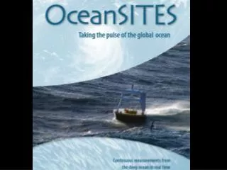
A global ocean timeseries observatory system is under development internationally • Started as GOOS/CLIVAR/POGO sponsored (via OOPC/COOP) activity • The system is multidisciplinary in nature, collecting physical, meteorological, • chemical, biological and geophysical timeseries observations • Goal is to make the data are publicly available as soon as received and quality-controlled by the owner/operator • An International Steering Team provides guidance, coordination, outreach, and • oversight for the implementation, data management and capacity building (18 scientists operating sites, representing all ocean disciplines) • A pilot system has been defined consisting of all operating sites • and those planned to be established within 5 years, subject to evaluation in • terms of the qualifying criteria by the Science Team.
Definition of an ocean timeseries site in OceanSITES • Sustained in-situ observations at fixed geographic locations of ocean/climate related • quantities at a sampling rate high enough to unambiguously resolve the signals of interest. • only truly Eulerian data, i.e. no ship sections or underway data, no surveys with vessels or gliders around a site. But PRODUCTS derived from other systems, e.g. transport timeseries from ferry ADCP sections, would be included in data base. • Transport sections using whatever technique are included in choke points and major • boundary current systems IF based on Eulerian data (moorings, gliders, tomography, etc) • Coastal timeseries are included when they are instrumented to have multidisciplinary • impact on the global observing system and if they are not part of a national coastal buoy • network. • Any implemented site fulfilling criteria will become part of the system but has to deliver • its data into the system and to demonstrate successful operation and value after 5 years. • Real-time data telemetry of operational variables will be pursued, i.e. make effort if • technically feasible • Agreement to make data public in near real-time for real-time data or as soon as processed • and post-calibrated for other data
VISION … a global network of observatories, coordinated among many countries, serving many disciplines, providing data and products freely and in real-time... This is a realistic goal as will be shown in the following… A number of requirements and developments will enable and drive a sustained/operational future for moorings:
Requirement #1: Routine multi-disciplinary observations (physical, atmospheric, biogeochemical, geophysical, biological, tsunami) Geodetic/oceanographic mooring Labrador Sea convection and CO2 Bottom pressure Also zooplankton, fish, mammals... (all existing, feasible, proposed, planned)
Requirement #2: Telemetry systems and standardization Spar buoy for high-bandwidth satellite telemetry and power generation • Acoustic: • mooring sensors buoy • bottom sensors buoy • Inductive: • - mooring sensors buoy • Cables: • mooring/bottom sensors shore • Satellite links: • Iridium, ARGOS • high-bandwidth systems • Glider relais: • acoustic link to mooring/ bottom sensors, transmission via satellite when at surface • Standardization: • - agreed protocols (e.g.TCPIP) and hardware standards (signal levels, baud rate, acoustic encoding,etc) (all existing, feasible, proposed, planned)
Requirement #3: Mooring technologies Available now or in near future: surface and subsurface moorings, winched systems, cabled moorings, high-latitude spar buoys, virtual moorings, under-ice moorings,...
Requirement #4: Interdisciplinary and international Coordination OceanSITES near-term system • OceanSITES, a new action group of DBCP/JCOMM, sponsored by GOOS, CLIVAR, POGO. • Steering team • Pilot project • Data management team Sharing and coordination across disciplines strengthens sites for sustained moorings. E.g. the US ORION global mooring community merged the interests of physical oceanography, air-sea interaction, biogeochemistry, and geophysics to identify a prioritized list of sites of high multi-disciplinary interest. Also DART tsunami system…. International coordination is critical for sharing resources, addressing global issues, standardization and harmonization, attracting and serving a user community, data management, visibility and advocacy...
Requirement #5: Globally coordinated, consistent, efficient data management (strategies, technologies, infrastructure for ocean observatories) • Need: • data from the entirety of ocean observing systems should be easily available, in a single operation, in homogeneous formats • metadata vocabulary independent of sensors and platforms and disciplines • Solutions: • Infrastructure: • centralized global ftp servers (ARGO, GOSUD, Global Drifter Center,…) • distributed systems OpenDap (some major projects are starting… ) • Catalogues (JCommOps, EDIOS) • Syntax: • NetCDF format definitions (ARGO, OceanSITES,…) • GTS formats (DBCP, VOS, ARGO,….) • Progress made within single projects/communities (ARGO, GOSUD, OceanSITES, Mersea…)
data management (continued….) • Challenges: • Semantics: • Is a satellite SST equivalent to an In-Situ SST or a Model output SST? • Overarching solutions: • very complex to solve the problem as a whole, difficult to assemble all required expertises • in one group • explore mapping techniques between several standard vocabularies (MMI project) • Plan and Vision for Timeseries: • 2 global data portals (under construction in OceanSITES) • NetCDF format has been defined in consistency with other/prior program (e.g. ARGO) and with the US DMAC philosophy • multi-disciplinary data from all (public) deep-ocean timeseries sites will be available in real-time, with single queries • more challenging since several communities need to come together
Requirement #6: Homogeneous QC procedures Data from a SYSTEM of moorings is only useful if comparable/consistent within each other and with outside data Operational users must be able to trust consistent quality flagging/error estimates: - accepting erroneous data can cause erroneous forecasts - rejecting extreme but good data can lead to miss important events in forecast… Need consistent QC procedures between single moorings AND with other platforms • 3 required steps for moorings anticipated : • - real time QC needed by various operational users : required within a few hours ! Must be automatic (gross error tests, temporal coherence of the time series, consistency between different levels,..) • first delayed mode step before mooring recovery: e.g. statistical method to compare with historical and other data and spatial/temporal variability in the area offset/drift, error bars • second delayed mode step after mooring recovery: post-calibration, reduced uncertainty Methods from ARGO (profiles) and GOSUD (timeseries) are now being transferred to gliders and moorings in MERSEA experience will be brought to OceanSITES
Requirement #7: Sustained support (funding, infrastructure, organization, operation) GEO (Group on Earth Observation)http://earthobservations.org Achieve comprehensive, coordinated and sustained observations of the Earth system Timely, quality long-term global information as a basis for sound decision making. The ocean component is a major element of GEO, and will include an observatory/mooring network. Many countries are committing to GEO and to setting up the GEOSS. OceanSITES is working closely with POGO, Ocean-United and IOC to provide input to GEO. • GMES (Global Monitoring for Environment and Security)http://www.gmes.info • A concerted European effort to build end-to-end system for monitoring the environment and increasing civil security • make environmental and security-related information available • provide enhanced or new services • It is planned to include an organization for operational ocean observation, which is a natural home for an operational mooring activity. NOAA and NSF: http://www.noaa.gov, www.orionprogram.org The US NOAA Office of Global Programs is supporting a number of sustained “ocean reference stations“, with a projected growth towards a larger contribution to a global network. NSF ORION program is under contruction.
Requirement #8: Interaction with users and definition/provision of products • Like other sustained systems, timeseries needs also have to be defined by applications and users • environmental and climate monitoring • science needs • modelling and forecasting (validation) “reference stations“ • management of natural/living resources • hazard warning and mitigation • .... • Add value to data by providing products and indicators, e.g. • intensity of processes (air-sea fluxes, critical vertical/horizontal exchanges, productivity,....) • state and health of the ocean&atmosphere (physics/climate, ecosystem, inventories, chemicals, populations,...) • forecast/warning indicators (El Nino, NAO, blooms, pollution, earthquake,...) • (Funds are being sought from NOAA for a scientific support position with this goal)
Status and Developments Since JCOMM 2005 meeting in Halifax, OceanSITES is a recognized component of global ocean observing system being integrated under GOOS, JCOMM, etc.
Outcomes of OceanSITES meeting, February 06, Hawaii • requesting special status wrt DBCP: both action group and science project (since not operational, many differences like ship-based and watercolumn, no project office support, etc) • OceanSITES Data Team met for first time and agreed on wide range of issues, approaches, architectures (more below) • OceanSITES website was transferred to WHOI/CICOR and design reviewed • OceanSITES brochure was reviewed and fine-tuned (available in print now) • Clarification on what type of timeseries are included in OceanSITES: only truly Eulerian ones, i.e. no ship sections or underway data, no surveys with vessels or gliders around a site. But PRODUCTS derived from other systems, e.g. transport timeseries from ferry ADCP sections, would be included in data base. • OceanSITES involvement in Ocean-United and GEO agreed
Counting and nomenclature of sites/network Clarify name: Best is “ocean reference station” = “observatory” = “ocean timeseries site” Make clear when only air-sea flux reference stations are meant.
Tropical arrays: • Agreed to include/keep in OceanSITES format regardless of transitioning to DBCP (included Don Conlee in Steering Team for this). • Count routine tropical arrays separately and shows as box. • Include the enhanced or “super” sites in reference network counting and show as separate sites
OceanSITES Data System • A data format has been agreed on, modelled after ARGO, consistent with other international and US efforts, NetCDF • conventions on architecture and procedures established (DAC’s, GDAC’s, portals, etc)
OceanSITES Data System • Coriolis/IFREMER started to be one GDAC, waiting to hear about a NOAA GDAC • Sample data are flowing now from - WHOI air-sea flux sites - ANIMATE/MERSEA sites - NOAA/KEO mooring - Dickey Bermuda mooring - MOVE moorings - MBARI moorings (under way) - ship hydrography from Hawaii/Bermuda (under way) • Plan to expand and invite others, once data system and format is demonstrated and operational • in future, it will be a requirement to contribute data publicly, in order to be part of OceanSITES, reflected on implementation maps
Science Implementation Scientific applications are driving most of the existing sites at present… circulation air-sea flux biogeochemistry
Website www.oceansites.org
Invitation to other projects present (IMBER, SOLAS, GEOTRACES, etc) • to • express interests and rationales for specific timeseries sites (existing or additional ones) • cooperate on implementation, maintenance, operation of sites • cooperate on data system for timeseries-type data
5-year internal transport timeseries from ongoing MOVE project
US/NSF OOI/ORION initiative Ambitious “transformative” long-term infrastructure enabling novel research(interactive communication/control to all sensors, seafloor, moving platforms, profilers, many sensors and disciplines, adaptable)
(F.Bryan et al) Realtime boundary current observing system under development • Moorings: • determine net mass transport, including eddies, recirculations,... • For heat transport need • vT dx dz : Gliders: provide regular upper layer T-weighting of v distribution in stream coordinates • IES+pressure: • when upper-layer flow and heat content is know, this provides lower-layer correlation of v and T.
Possible configuration….
Possible issues for JCOMM • facilitate cooperation with other communities (tsunami, waves, etc) • facilitate sharing of ships (including inter-agency, e.g. NOAA-UNOLS) • facilitate sharing of infrastructure, e.g can ORION and NOAA contribute to upgraded PAPA or Peru Stratus moorings ? • help with advocacy to GEO: what do JCOMM and IOC do ? • help with project office support ?