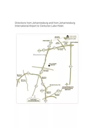
Directions to Camp Entrance via HWY 65 and HWY H from I-70 and Hwy 52
Follow these detailed directions to reach the camp entrance. Starting from I-70, take HWY 65 South for approximately 16 miles to Sedalia. Continue South on HWY 65 to Lincoln, MO, about 20 miles away. After one mile past Lincoln, turn left onto H Hwy, 12 miles ahead. When you approach Edmonson Baptist Church on your left, turn right onto Heit’s Point Ave. After 1.4 miles, the camp entrance will be on your right. If coming via Hwy 52, take W Hwy to reach H Hwy, then follow the same steps to arrive at the Spitz Center check-in.
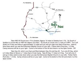

Directions to Camp Entrance via HWY 65 and HWY H from I-70 and Hwy 52
E N D
Presentation Transcript
Take HWY 65 South from I-70 to Sedalia (Approx 16 miles to Sedalia from I-70). Go South of Sedalia to Lincoln MO on HWY 65 (Approx 20 miles). Go South of Lincoln one (1) mile to H HWY. Turn Left (East) on H Hwy and follow it approximately 12 miles and you will turn right onto Heit’s Point Ave., (start to slow down when you see the Edmonson Baptist Church on your left). Follow Heit’s Point Ave. 1.4 mile. Camp entrance will be on your right. Come to the bottom of the hill and check in at the Spitz Center. OR Take Hwy 52, which runs East and West between Hwy 54 and Hwy 65. Turn onto W Hwy, which is 5 miles West of Stover or 7 miles East of Cole Camp. Take W Hwy 17 miles to H Hwy. Turn left onto H and go 2 miles (start to slow down when you see the Edmonson Baptist Church on your left). Follow Heit’s Point Ave. 1.4 mile. Camp entrance will be on your right. Come to the bottom of the hill and check in at the Spitz Center.