Download
1 / 32
320 likes | 486 Vues
IRI/LDEO Climate Data Library. M.Benno Blumenthal, Michael Bell, John del Corral, Remi Cousin, and Haibo Liu International Research Institute for Climate and Society Columbia University http://iridl.ldeo.columbia.edu/.

E N D
IRI/LDEO Climate Data Library M.Benno Blumenthal, Michael Bell, John del Corral, Remi Cousin, and Haibo LiuInternational Research Institute for Climate and SocietyColumbia Universityhttp://iridl.ldeo.columbia.edu/
The Data Library's open data model and ability to create networks of virtual web pages and resources leads to some powerful applications What follows is a brief explanation and some examples Structure leads to powerful applications
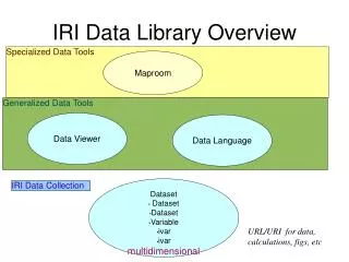
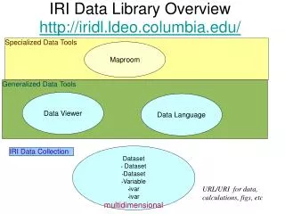
Specialized Data Tools Maproom Generalized Data Tools Data Viewer Data Language Dataset • Dataset • Dataset • Variable • ivar • ivar multidimensional IRI Data Collection Overview URL/URI for data, calculations, figs, etc
Economics Public Health “geolocated by entity” • IRI Data • Collection • Dataset • Dataset • Dataset • Variable • ivar • ivar • multidimensional IRI Data Collection Ocean/Atm “geolocated by lat/lon” multidimensional GIS “geolocation by vector object or projection metadata” spectral harmonics equal-area grids GRIB grid codes climate divisions
GRIB netCDF images binary spreadsheets shapefiles Database Tables queries Servers OpenDAP THREDDS images w/proj • IRI Data • Collection • Dataset • Dataset • Dataset • Variable • ivar • ivar IRI Data Collection
GRIB netCDF images binary spreadsheets shapefiles Database Tables queries Servers OpenDAP THREDDS images w/proj • IRI Data • Collection • Dataset • Dataset • Dataset • Variable • ivar • ivar images graphics descriptive and navigational pages Calculations “virtual variables” Clients OpenDAP THREDDS Data Files netcdf binary images OpenGIS WMS/WCSKML Tables IRI Data Collection
IRI General Data Tools Data Page
IRI General Data Tools Data Viewer
IRI General Data Tools Calculations: svd (link: svdview) (link: svd results dataset) (link: svd documentation)
IRI General Data Tools Calculations: Cluster Analysis (link: cluster view) (link: cluster results dataset) (link: k-means fn)
IRI General Data Tools WMS and KML: land cover (link:figure page)
IRI General Data Tools WMS and KML: precipitation (link: figure page)
IRI Map Room Malaria Early Warning System • Front page illustrates most recent dekadal rainfall estimates (FEWS RFE) • Administrative and epidemiological overlays available • Change dates to view different time periods • Click and drag box across map to zoom
IRI Map Room MEWS Time Series Analyses STEP 1: Select size of domain for analysis Administrative District OR Box – 11km, 33km, 55km, 111km STEP 2: Select location for which analysis will be created
IRI Map Room MEWS Time Series Analyses
If not destroyed early, Desert Locust can damage crops and cause famine across multiple countries Food Security: Desert Locust Management Monitoring vegetation in desert areas is required
I. Food Security: Application At the request of the UN FAO, a web-based tool was created to support Desert Locust management and control • Eliminates NDVI-based error for identification of locust habitat • Adds daily and 10-day CMORPH rainfall estimates for identification of potential breeding areas Michael Bell, Benno Blumenthal
I. Food Security: Application In Feb 2007, vegetation was detected using IRI MODIS images. The information was used by the Ministry of Agriculture in Asmara to send control teams to the coastal area. Desert Locusts were found and control measures taken.
I. Human Health: Disease Transmission In West Africa, the nomad population is at risk of contracting and transmitting water vector-borne diseases throughout the populations of Burkina Faso, Mali and Niger UN WHO requested a tool to monitor water bodies in this region UN WHO NOMADE project
I. Human Health: Disease Transmission IRI provides Short Wave Infrared composite images, enabling UN WHO to monitor and integrate water bodies into their Healthmapper GIS MODIS images at 250m spatial resolution composite
I. Human Health: Application MODIS images: composite and NDVI are now available through IRI Health Maproom Ministry of Health in Eritrea follows NDVI indices on regular basis and provides warnings to the sub-districts Michael Bell, Benno Blumenthal, John del Corral, Emily Grover-Kopec
I. Fire Management: Fires in Indonesia Fires in Kalimantan release CO2 and smoke creating human health respiratory and air traffic problems CARE Indonesia funded IRI to create Early Warning and Early Action Systems to manage Fires in peatland areas
Fire Management Michael Bell, Benno Blumenthal, Joshua Qian, Andy Robertson, Michael Tippett Presentation of the tool to CARE and Ministry of Environment (Indonesia). Improvement and publications are in progress
Results Semantic Web Data Data Data Flow based Analysis with explicit semantics analysis data data analysis