Stipulation Database Development Sponsored By: Ground Water Protection Council
170 likes | 275 Vues
This project, sponsored by the Ground Water Protection Council, aims to abstract, enter, verify, and standardize stipulation data related to oil and gas operations. It involves collaboration with state agencies and field offices to ensure accurate data collection and distribution. The project will enhance the existing Geographic Coordinate Database (GCDB) and improve data accessibility for various user groups. Essential contributions are expected from multiple sections including mineral leasing, planning, and GIS staff to ensure comprehensive coverage and compliance with regulations.

Stipulation Database Development Sponsored By: Ground Water Protection Council
E N D
Presentation Transcript
Stipulation Database DevelopmentSponsored By: Ground Water Protection Council Lease Stipulation Project Review and Discussion Prepared by: Premier Data Services May 9, 2007 Benjamin Knott
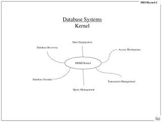
Stipulation Database Development Project Focus: • Stipulation Database Development • Ownership Data Development • GCDB Edit And Enhancements • Data Distribution Through State OGCC Project Owner: • The Ground Water Protection Council • Department Of Energy (Access To Federal Lands Study) Project Summary: • To abstract, enter, verify, and standardize stipulation data associated with oil and gas operations and decision support data for other user groups.
EPCA Basins 87 Field Offices 26 Study Areas/Basins
Input Formats Farmington Carlsbad
Data Capture Work Flow Stipulation Data Collection
Input Required • Participation is needed from the following: • Fluid & Solid Mineral Leasing Section • Standard stipulation coding (input files) • Standard stipulation language • Planning Staff • State and Field Office participation • GIS Staff • Stipulation coverage's • Accurate ownership, split estate and SMA data • State Agency Input • Montana Game & Fish • Montana SHPO
Abstract Resource Management Plans and Amendments • Abstracting Process • Review the most current RMP, ROD and Amendments • Record the geographic name (i.e. alleged UFO crash site) • Record the resource decision (fluid minerals mgmt., solid leaseable min., etc) • Determine if there is a legal description or maps to show locations • Determine the availability of GIS support data • Determine areas for archeology, wildlife, fish, plant species, etc… • Determine surface use restrictions, OHV etc…
Data Dependencies • Accurate Boundaries Are Critical
Accurate Ownership Based On LR-2000 • Process From Status • Process From Case Rec. • Merge Data • Simplify • Identify: • SMA • Public Domain • Split Estate
Merge Stipulation Shapefiles Black Footed Ferret ACEC MT-12-1 (Soils) MT-13-3 (Grouse Nesting Zone) Terry Badlands WSA
Data Processing/Integration(Abstract, Enter, Verify) • Resource Management Plans • GCDB • LR2000 (Status/Case Rec) • Montana Cadastral Database • Stipulation Data Collection
Stipulation Data Collection Stipulation Data Sources • BLM Montana State Office • BLM Website (www.mt.blm.gov) • RMP Maps & Land Descriptions • Other Federal Agencies
Contact Information Ben Knott Premier Data Services8310 South Valley Highway, Suite 220Englewood, CO 80112800-210-9100303-377-0033FAX 303-377-3663 E-mail: ben.knott@premierdata.com
Simplify Stipulations • Process “simplify” legal scripts • Join export file to GIS shapefile • Dissolve on all fields • Join abstract database