Download

1 / 8
80 likes | 195 Vues
Learn about the significance of GIS in agriculture and suitability analysis using the Nile Goblet tool. Explore geographic data layers, suitability criteria, and how GIS informs best practices. Practice using the open-source tool for location-specific analysis.

E N D
Geographical information systems Catherine Pfeifer ILRI/IWMI & Yenenesh Abebe IWMI
Plan • Crash introduction into what is GIS • Importance of GIS in agriculture • The concept of suitability • The Nile-Goblet open source tool • Test yourself the Nile Goblet tool
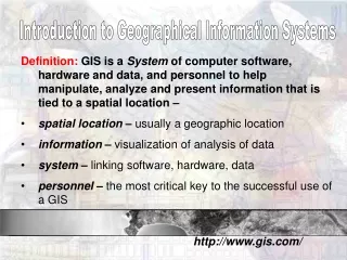
What is GIS • Geographic, so we know that GIS has something to do with geography. • Information, so we know that GIS has something to do with information, namely geographic information. • System, so we know that GIS is an integrated system of geography and information tied together.
What is GIS? • Computer system • Hardware • Computer, plotter, printer, digitizer • Software and appropriate procedures • Spatially referenced or geographic data • People to carry out various management and analysis tasks
What is GIS ? • Geographic layer = geographic data • Vector data • Point • Lines • polygons • Raster data • grid
GIS for agriculture • Technology/practices/crops depend on the bio physical environment • Best practices are location specific • GIS can inform what works where • Suitability analysis
Suitability analysis Select a location • where given conditions for a best practice are met Example : terraces • Slope : 12-50% • Rainfall 800-2000 mm annual rainfall • Not on vertisol
Nile Goblet tool • Open source GIS software for suitability analysis • No need for prior GIS knowledge • Dataset has been prepared for RMS in the Ethiopian Blue Nile • Flexible tool, can be adjusted for different location and different practices technologies.