Download
1 / 18
180 likes | 194 Vues
Learn about watersheds, engage in local actions with fact sheets, and protect vital resources. Take part in this community-led effort to promote clean water and land use management. Discover the importance of watershed planning and access valuable resources for informed decision-making.

E N D
Watershed Literacy & Engagement League of Women Voters of Wisconsin and LWVLMR 2017
100 Watershed Meetings honoring 100th Anniversary of LWV in 2020 • The League of Women Voters of Lake Michigan began this challenge in 2015 to not only promote meetings but also gather tools to aid local league meetings. • A key tool was an example set of Lake Michigan Watershed Fact Sheets published by US EPA in 2008. • We are using League grant support to update these concise overviews that use data from multiple federal and state agencies • We hope this pilot will build capacity for any Leagues interested in fact sheet development.
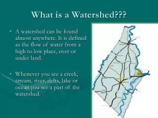
What is a Watershed? HUC? • A watershed is an area where all rain runs off or drains into the same river or lake. • A hydrologic unit code (HUC) is a sequence of numbers or letters that identify a hydrological feature like a river, river reach, lake, or area of a drainage basin . • There are 34 8-digit HUCs surrounding Lake Michigan • The numbers were developed by US EPA and USGS and the states.
US Major Watershed Snapshot • https://water.usgs.gov/wsc/map_index.html
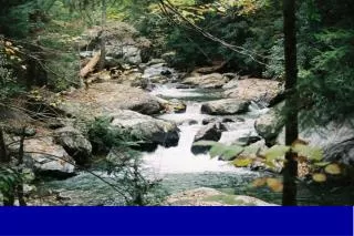
Why watersheds? • Watershed planning specifically addresses water problems in your community and watershed. • Clean, abundant water, and safety from flooding are important for residents and businesses • How water flows and collects in streams, wetlands and lakes is based on landform • Water flow generally does not follow political jurisdiction boundaries so most water resource problems need to be addressed at the watershed level, which frequently involves several political jurisdictions.
Needed: A Community-Led Process • Watersheds are best understood at the local level by local residents • As a resident, landowner, business or community official your actions make a difference in keeping water in clean, reducing flooding, and protecting natural areas that help do both as well as providing habitat and places for people to recreate. • Understanding watersheds helps communities, residents and regional officials address problems and protect resources.
Elements of a Watershed Fact Sheet • Watershed HUC and list of sub-watersheds: this element of the fact sheet does not change ! • Watershed groups and activities • Watershed over view • Land use • Impaired Waters • Drinking Water Source • Anything special in your watershed with special community interest, like being an AOC, tribal lands or fishing rights
Watershed Fact Sheets • List sub-watersheds • Overview of groups • Overview of significant elements
Sources for Watershed Fact Sheets • Free information provided by many federal and state agencies • New information and data identified from research found on line from the appropriate agency, • Working with other local watershed groups • Data is on line, in publications or can be found through a conversation with agency staff
Element 2: Watershed groups and activities • Local league and partners usually know sources • Surf Your Watershed • www.epa.gov/surf • Google searches
Element 3: Watershed Overview • Watershed maps, U.S.G.S. and state agencies 2. State materials, reports of any CWA 319# work 3. Regional Planning Commission 4. Area Of Concern status reports if one is in the area • Habitat reports, threatened or endangered species • National Wetlands Inventory, NWI of US Fish and Wildlife Service • Watershed Assessment, Tracking, and Environmental Results (WATERS)
Element 4: Land Use • Local planning commission maps • NOAA Coastal Website • Provides online data viewer provides user-friendly access to coastal land cover and land cover change information developed through NOAA’s Coastal Change Analysis Program (C-CAP). • Summarizes general change trends (such as forest losses or new development) and provides tables, maps, and reports to enhance communication and decision-making. • Explore land cover changes by county or watershed • Visualize different types and specific locations of change
Element 5: Impaired Water • How are waters in the watershed polluted or otherwise impaired - http://dnr.wi.gov/topic/tmdls/ • Impaired waters in Wisconsin are largely addressed through an analysis, known as a Total Maximum Daily Load (TMDL). • A TMDL is the amount of a pollutant a waterbody can receive and still meet water quality standards. Basically a TMDL is a pollution "budget" for a water body or watershed that establishes reductions needed from each pollutant source to meet water quality goals. • While some waters may be restored through alternative projects such as Watershed Restoration Plans, many issues are addressed through TMDLs.
Element 6: Drinking Water Sources • Envirofacts https://iaspub.epa.gov/enviro/sdw_form_v3.create_page?state_abbr=WI • Local “Consumer Confidence Reports” on water utility websites and in annual report to all users. • A watershed is often the “source” of local drinking water 4. Please note: this was not part of the original fact sheets but current interest indicates the need to provide information on drinking water sources. 5. Condition of water distribution system is also key
Element 7: TBD • Every watershed is unique and the challenges vary. This is an opportunity to add an element to the fact sheet that is of special interest to the community. • Examples could be terrestrial or aquatic species, a special zoning need or area in need of, or possible restoration potential. • Consideration needed for how to distribute information either hard copy or via web sites and at meetings