Download

1 / 22
230 likes | 397 Vues
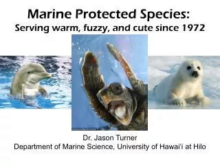
What’s in and what’s not: using the new global seafloor geomorphic map to examine the representativeness of global marine protected areas Miles Macmillan-Lawler, Peter Harris, Elaine Baker, Jonas Rupp GRID-Arendal, Geoscience Australia, Conservation International.

E N D
What’s in and what’s not: using the new global seafloor geomorphic map to examine the representativeness of global marine protected areas Miles Macmillan-Lawler, Peter Harris, Elaine Baker, Jonas Rupp GRID-Arendal, Geoscience Australia, Conservation International
Why Seafloor Geomorphology? • Seafloor geomorphology can be mapped at global scale using existing data • Is a useful surrogate for biodiversity at the global scale. i.e Seamounts have a different suite of species to Abyssal Plains • Support improved management of the marine environment (eg MSP, feature inventories) • Can be built upon using other physical and biological data
Geomorphic Feature Interpretation • SRTM30Plus v7 + other data • Features defined based on shape, slope, rugosity and TPI • Combination of automated algorithms and expert interpretation • Minimum feature size mapped ~10 square kilometres
Global MPAs – WDPA August 2013 version
CDB - Aichi Target 11 By 2020, at least 17 per cent of terrestrial and inland water areas and 10 per cent of coastal and marine areas, especially areas of particular importance for biodiversity and ecosystem services, are conserved through effectively and equitably managed, ecologically representative and well-connected systems of protected areas and other effective area-based conservation measures, and integrated into the wider landscape and seascape.
Global Status of MPAs • 3% of the oceans in MPAs • 97% of MPAs in EEZs • Majority of MPAs small • Majority of area from few large MPAs
Abyssal Plains – Globally 0.7 % in MPAs Cape Verde Abyssal Plain
Seamounts – Globally 2.9 % in MPAs Kelvin seamount in northwest Atlantic
Trenches – Globally 8.5 % in MPAs Japan Trench
Less than 3% of MPAs are in ABNJ Trenches Seamounts Abyssal Plains Representation in MPAs
Globally what’s in and what’s not? • Feature representation ranges from 0.5 and 8.5% • Deep water features poorly represented • Representation of features varies in the different oceans • Features in ABNJ poorly represented
Seafloor geomorphology to characterise EEZs of the Pacific Region
Seafloor features of Pacific Region * compared to proportion of feature at global scale ** features not present in region
Summary of geomorphic feature representation in MPAs in the Pacific Region • The three shelf classes are the best represented features in MPAs in the region, between 6 and 12 %. • Most of the features that are characteristic of the region (e.g. escarpments, seamounts, abyssal mountains, ridge and guyot) are represented between 1.5 and 3.5 % of their area in MPAs • Several ecologically significant features not represented in MPAs in the region (eg canyons, spreading ridges, rift valleys)
Summary • Seafloor geomorphology provides an insight into how global MPAs are achieving the Aichi Target 11 • Especially useful in assessing whether global MPAs are capturing areas of particular importance for biodiversity and if they areecologically representative • Seafloor geomorphology can be used to identify gaps in MPA coverage
Questions? • miles.macmillan-lawler@grida.no • grida.no • bluehabitats.org (comming soon)