the sea floor
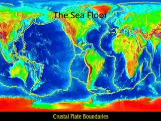
the sea floor. seafloor. • water covers 70% of Earth’s surface. seafloor map from Dana (1894). seafloor. • deep seafloor largely unknown prior to 1950’s. seafloor. • oceans originated mostly from volcanic de-gassing of water vapor from Earth’s interior.

the sea floor
E N D
Presentation Transcript
seafloor • water covers 70% of Earth’s surface
seafloor map from Dana (1894) seafloor • deep seafloor largely unknown prior to 1950’s
seafloor • oceans originated mostly from volcanic de-gassing of water vapor from Earth’s interior additional small amount may have come from late comet impacts after the Earth reached close to its current mass
studying the seafloor direct methods • rock dredges • sea floor drilling • submersibles indirect methods • sonar • seismic reflection profiling
direct methods rock dredges
direct methods sediment corer
direct methods sea floor sediment core
JOIDES Resolution (1990’s-being overhauled) DSDP (Deep Sea Drilling Project); ODP (Ocean Drilling Project) …IODP (Integrated Ocean Drilling Project)…
Chikyu Japanese drill ship
direct methods submersibles • manned or unmanned
indirect methods sonar (sound navigation and ranging) • sound sent from ship, bounced off sea floor, and recorded at ship distance to seafloor is calculated from speed of sound in water multiplied by time to get return signal divided by two (wave goes down and up)
indirect methods known for a long time that sound travels through water 1822 attempt to determine speed of sound in water
indirect methods seismic reflection • penetration of sediments by sound waves • hydrophones record signals echo sounding, swath bathymetry, sidescan
indirect methods sea floor profile
indirect methods South Pacific sea floor
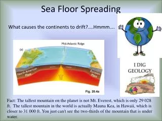
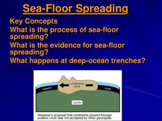
seafloor, continents, and plate boundaries yellow lines are plate boundaries sea floor was critical in development of plate tectonics
features of the seafloor general profile through ocean from left to right shelf, slope, abyssal plain, mid-oceanic ridge seamounts, trench, slope shelf passive continental margin (no plate boundary) active continental margin (plate boundary) mid-oceanic ridge (plate boundary)
continental shelf and slope • broad, shallow shelf (100-200 m water depth) • steeper slope dives to abyssal plain topographic profile has 25x vertical exaggeration (vertical and horizontal scales are not the same) slope angle is only 4-5°
passive margin NO plate boundary at edge of continent • shelf and slope • continental rise (less steep than slope) • abyssal plain (smooth, deep seafloor)
submarine canyons and abyssal fans • start on shelf and end at base of slope • allow for transport of sediment from shelf to sea floor
submarine canyons and abyssal fans (California) “turbidity currents” flow down canyons and deposit on fans
submarine canyons landslide triggered by earthquake cable breaks in different locations at different times as landslide arrives
continental rises and abyssal plains continental rise: gently sloping wedge of sediment of sediment at base of slope sediments deposited by turbidity currents and contour currents move along elevation contours abyssal plain: flattest region on Earth; form where turbidity currents bury features
active margin plate boundary at edge of continent • shelf and slope • oceanic trench (deepest features in ocean) • volcanoes (on-land) Wadati-Benioff zone --dipping zone of earthquakes that begin at trench and extend landward (red stars)
mid-ocean ridge • 80,000 km long; 1,500-2,500 km wide • elevations of 2,000-3,000 m above sea floor • rift valley ~1,000 m deep at crest of ridge axial valley NORTH AMERICA AFRICA sea floor spreading (divergence) from: http://www.geo.duke.edu/geo41/sfs.htm
mid-ocean ridge • basalt flows and volcanism • high heat flow and small, shallow earthquakes • hot springs supporting biological communities
black smoker (first ever seen) 1979
life at oceanic ridge tube worms spider crab giant clams
explore using submersibles ALVIN was first one; 3 passenger
mid-ocean ridge • exposed on-land in Iceland both from: http://pubs.usgs.gov/publications/text
mid-ocean ridge transform faults • offset of mid-ocean ridge between adjacent ridges --earthquakes occur along them (red stars)-- fracture zones • continuation of transform fault beyond ridge --no eq’s--
transform fault--fracture zone animation greenare ridge segments;redis transform fault
from: http://www.whoi.edu/page.do?pid=7545&tid=441&cid=49514&ct=61&article=29566
other sea floor features seamount conical mountain that rises > 1,000 m above sea floor; basaltic volcanoes; chains of seamounts occur (aseismic ridges) (Emperor seamounts) guyot flat-topped seamount; erosion from waves; reefs common around them
seamount chains and ages of seamounts in one (hot spot track -- more later) Emperor seamounts
sea floor sediments terrigenous: derived from land and brought to sea floor …sands/silts that make up continental rise… pelagic: accumulate by settling through water column …clays from wind; skeletons of microsopic organisms… sea floor spreading leads to greater thickness of pelagic sediments away from ridge crest (no sediment at mid-ocean ridge)
composition of the oceanic crust seismic surveys suggest ~ 7 km thick with 3 layers 1) marine sediments (sampled) 2) pillow basalts (sampled) 3) gabbros (not sampled) (intrusive equivalent to basalt)
resources of the ocean offshore drilling