Integrated Water Resources Science and Services: Addressing the Nation's Challenges
This document outlines key drivers, challenges, and imperatives in the field of water resources, stressing the importance of collaboration in addressing growing water challenges. It emphasizes the impact of population growth, climate change, and aging infrastructure on water resources, highlighting the need to protect life, property, and the environment. The document discusses a 5-point strategy and primary areas of focus for NOAA in addressing water-related issues, emphasizing the need for improved water information to manage risks and enhance economic security. It also details efforts to enhance community resiliency and support the water economy through integrated science and services. The text addresses real-world challenges, stakeholder needs, and the importance of federal collaboration in providing critical water information for decision-makers across various sectors.

Integrated Water Resources Science and Services: Addressing the Nation's Challenges
E N D
Presentation Transcript
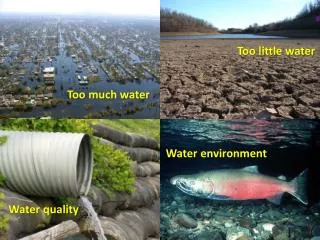
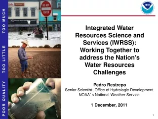
TOO MUCH Integrated Water Resources Science and Services (IWRSS): Working Together to address the Nation’s Water Resources Challenges TOO LITTLE Pedro Restrepo Senior Scientist, Office of Hydrologic Development NOAA’s National Weather Service 1 December, 2011 POOR QUALITY
Outline • Drivers • Growing water challenges and impacts • National imperatives and stakeholder needs • Real world challenges • New Business Model • 5-point strategy • Primary areas of focus for NOAA
Triple Threat Population growth and economic development are stressing water supplies and increasing vulnerability A changing climate is impacting water availability and quality, increasing uncertainty Aging water infrastructure is forcing critical, expensive decisions Water Challenges National Imperative • Protect Life and Property • Support Economic Security • Protect Health and Environment • Mitigate Escalating Risk Blue Gold, “The New Oil”
Growing Socio-economic Impacts • Floods • The annual average damage due to flooding has risen each of the past three decades (costs adjusted for inflation) • 1981-1990: $4.7 Billion • 1991-2000: $7.9 Billion • 2001-2010: $10.2 Billion • 2011 combined flood losses along the Mississippi and Missouri Rivers are expected to exceed $6 Billion (USA TODAY; USACE) • 2011 combined flood losses throughout the eastern U.S. from Hurricane Irene and Tropical Storm Lee are expected to exceed $10 Billion (NY Times) • Drought • 2011 impacts in Texas alone are expected to exceed $9 Billion (Associated Press; Time Magazine) • $5.2 Billion - Rural Communities • $2.0 Billion - Cattle Ranchers • $1.8 Billion - Cotton Industry
Our Stakeholders are Concerned Decision-makers in water management sectors say they need: • Expanded/new high resolution water information in space and time to inform decisions • Simplified access to better integrated information • Quantification of uncertainty to manage risk • Enhanced communication of flood risk using flood forecast maps NWS completed extensive outreach to objectively define, validate and prioritize stakeholder needs • Partnered with Claes Fornell International (CFI) Group and David Ford Consulting Engineers • surveyed users of NOAA’s hydrologic information via the American Customer Satisfaction Index (2002, 2004, 2006, 2008, 2011) • carried out national surveys and targeted user forums with emergency managers, private sector, media, and water resources managers USACE conducted National Needs Assessment for all 50 States
24 Federal Agencies have a role in fresh water Water resources activities are primarily independent Flood operations coordinated through USACE District Offices, USGS Science Centers, and NOAA/NWS River Forecast Centers Unique, non-standard exchange mechanisms for critical data (email, phone and web are common) Limited leveraging of R&D investments or sharing of technology, modeling capabilities, and expertise Research to operations activities are often time and labor intensive Real World Challenges: Federal Collaboration
Grand Challenge Work with partners and stakeholders to provide enhanced water information to: • Understand water availability, threats, and uncertainties • Help water managers and decision makers understand, adapt to, and reduce risk • Improve social and economic security • Support the nascent Water Enterprise to stimulate the growing water economy How?
Integrated Water Resources Science and Services5-Point Strategy 2009 IWRSS Roadmap
Improve Community Resiliency Planned for FY13 and beyond: Maps Linked to River Forecasts, Updated Every 6 Hours • 2011 Multi-Agency Collaboration Proof of Concept will be linked to actual river forecasts • Builds on successful Fargo ND Pilot Project, demonstrating dynamic forecast maps updated 4X / Day • Actual flood wave is forecasted and depicted Forecast is for gauge 1.7 miles upstream Conventional Flood Forecast Hydrograph
Fueling the Water Economy Planned for FY13 and beyond: Raw materials to support the nascent water enterprise Pilot Products - Snowpack Summit-to-Sea GIS-Ready Water Resources Products Local Information (<1 km2) Snowfall Precipitation Snowpack Soil Moisture Snow Depth Evapotranspiration Groundwater River flow Water Content Surface Storage Water Quality Snow Temperature Watershed – to – National Information www.nohrsc.noaa.gov IWRSS Forecasts USGS WaterSMART Initiative Past Present Future Snowmelt