
School Hydrological Information Network ( SHINe ) Program
E N D
Presentation Transcript
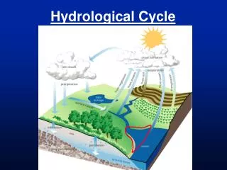
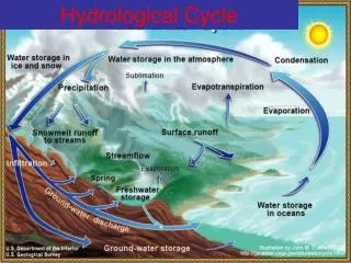
Hydrometeorology Meteorology – study of atmosphere on weather processes and forecasting Hydrology – study or knowledge of water or the water cycle
Common weather systems affecting the Philippines: Monsoons Inter-tropical Convergence Zone Thunderstorm Cold Front Tropical Cyclone
Tropical Cyclone • Intense low pressure system with minimum sustained winds of 35 kph • The country average of about 20 Tropical Cyclones annually. • Winds are most damaging to structures but most casualties result from flooding.
Classification of TC in the Philippines • Tropical Depression – winds of • 35 kph to 63 kph • Tropical Storm – winds of 64 kph to 117 kph • Typhoon – winds of more than 117 kph
Public Storm Warning Signals in the Philippines (PSWS) PSWS No. 1– a TC may threaten or affect the locality. Winds not more than 60 kph may be expected in at least 36 hours (1.5 days) PSWS No. 2 – a TC may threaten the locality. Winds from 61 kph to 100 kph may be expected in at least 24 hours
Public Storm Warning Signals in the Philippines (PSWS) PSWS No. 3– a TC will affect the locality. Winds from 101 kph to 185 kph may be expected in at least 18 hours. PSWS No. 4 – A very strong typhoon will affect the locality. Very strong winds of more than 185 kph may be expected in at least 12 hours.
Hazards associated with TC • Strong winds – immediate TC hazard to affect a community • Storm surge – due to winds of TC and the low pressure area
Hazards associated with TC • Landslides – influenced by intensity of rains, soil characteristics, slope, land cover, infiltration, groundwater level, etc. • Floods and Flashfloods – due to rainfall volume, basin, & river characteristics, drainage problems, informal settlers, etc.
Types of Floods River overflowing (Riverine) Accumulated rainwater (Ponding) Dam releases and Dam breaks Coastal flooding – high tide, storm surge & tsunami Tsunami
Causes of Flooding Rains – primary source River basin characteristics Narrow and winding river channels Siltation & sedimentation of river channels
Flood mitigating measures: Structural mitigating measure: Dam, dikes, levees, cut-off channels, retarding basins, etc.
Flood mitigating measures: Non-structural mitigating measure: Zoning, reforestation, evacuation, sandbagging, hazard mapping, dredging, adaptation issues, ubiquitous flood hazard mapping signs, flood forecasting & warning systems, community-based warning systems, etc.
A non-structural flood mitigating measure • Can be quite simple & relatively cheap
Possible on a real-time basis • Envisage monitoring, info exchange, warning & disaster preparedness and response • Enhances the social & moral responsibilities of the locals/community through their direct participation.
CBBFWS rainfall & monitoring instruments Flood Markers Automatic Weather Station Dedicated Communication System Warning System
Activities to be undertaken in a SHINe Program 1. Installation of Rain Gauge & River (water level) Gauge, if school is quite close or very near a river.
This activity is undertaken by the PDMO with the support of the school officials/students • Possible placing a signage to the LCD Monitor of the rain gage to identify the SHINe Program
Activities to be undertaken in a SHINe Program Organize a SHINe group: members from Science Club & coordinators, etc.
Activities to be undertaken in a SHINe Program Installation of an Information Board ( for viewing TC location, PSWS info, TC track, forecast, other related infos.)
To be undertaken by the SHINe group in the school; board to be located in an area that can be seen by the whole school populace • A map of the Philippines to be placed in the info board; the board shall be updated whenever necessary by students assigned • Plotting & Tracking of Tropical Cyclone
Activities to be undertaken in a SHINe Program Daily observation of rainfall and/or water level following the proper procedures ( regular & during inclement weather conditions )
Scheduling of students to do the reading of rainfall &/or water level data, even during weekends & holiday. • Please follow procedures for observation • Also prepare a schedule for cleaning & maintenance of rain gage & water level gage.
Activities to be undertaken in a SHINe Program Fabricate prototype rain gage & tie-up observation with the rain gage installed in the school.
Students will make a prototype rain gage (glass, plastic, tube, etc.) & place around or near the rain gage; the prototype shall have means of measurements such as meter stick or graduated values at the outside if glass or any available measuring container.
Observations shall follow the time when the rain gage had been read. • Data from both the rain gage & prototype rain gage shall be written on a specified form; data shall also be encoded in a computer; likewise same observation from the water level gage to be written on specified form
Activities to be undertaken in a SHINe Program Provision of observed data to the PDMO-Bulacan whenever necessary. Daily provision after observation of 8 AM or hourly or 3-hourly if there’s an inclement weather; . . .
Activities to be undertaken in a SHINe Program … contacts & system of data transfer to be worked out during the orientation program; monthly submission of forms: by mail or e-mail, hand-in, etc.
Activities to be undertaken in a SHINe Program Students shall workout some simple presentations (and reports) to be presented after 3-4 months on the following:
Data observations (graphical); some possible explanation on the data/graph presented (group) • Presentation on the prototype rain gage & comparison with data from the installed rain gage; possible issues on data & some unusual readings, etc.
Presentation about the programs of the SHINe group: presentations on problems encountered with the program or with observations, scheduling issues, planned researches & activities, sustainability of the program, etc.
Activities to be undertaken in a SHINe Program Development of a webpage if possible. A group shall make a webpage of the SHINe program in their school; possible presentation of data observed, programs of the school in relation to SHINe, etc.
Activities to be undertaken in a SHINe Program An annual/bi-annual conference will be organized for all the SHINe groups from the various school involved in the program. Presentation from agencies, schools; school dynamics – contests, organization of network, etc.
Observation shall be done as follows: During normal days, no significant weather, every 8AM & 5 PM; During times of inclement weather (TC present, monsoon rains, etc.) every hour or 3-hours; Special observation whenever necessary during a brief heavy downpour, • or even during normal • period if able to do so
Always press the reset button after every observation. Log the data on the respective time-column & • day-row of the observation form.
If there’s no rainfall observed, • do not leave blank instead • place “0” corresponding to the • time & day on the form. Do not force • a data in the form if you were • not able to observe during that day. • If unable to observe the rainfall at • the respective time just fill-in the • accumulated data on the next-time • column otherwise leave blank.
Procedure for Water Level Observation: Similar with rainfall observation (8AM & 5PM on regular days & hourly or 3-hourly during inclement weather) If not able to observe at the specified time, leave it blank!
Maintenance Clean the Rain Gage with water every 6 months or whenever necessary Clean when there’s no rain. Do not forget to reset the LCD after cleaning the gage with water
Maintenance Replace the LCD monitor button-type battery after a year Wash the water level gage after every flood event or when there’s dirt on the gage repaint whenever necessary