Download
1 / 14
320 likes | 1.19k Vues
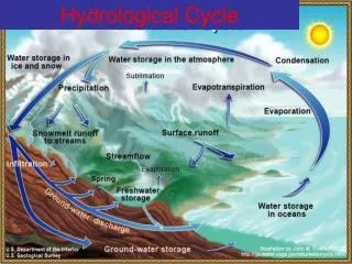
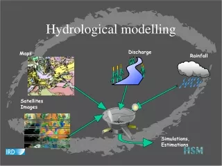
Hydrological modelling. Discharge. Maps. Rainfall. Satellites Images. Simulations, Estimations. SIEREM PROJECT : Environmental Information System on Water Resourses and their Modelling. Meteo Data : 27412 years for 342 posts. Rainfall data: 70651 years for 2737 posts.

E N D
Hydrological modelling Discharge Maps Rainfall Satellites Images Simulations, Estimations
SIEREM PROJECT : Environmental Information System on Water Resourses and their Modelling Meteo Data : 27412 years for 342 posts Rainfall data: 70651 years for 2737 posts Discharge data: 19749 years for 891 stations
SIEREM PROJECT : Environmental Information System on Water Resourses and their Modelling Geological cover of Ivory Coast Hydrographic network of Ivory Coast
The model - Presentation of POLLEN method • Developed by O. Gayte et al. • Adapted from the OMT method • Based on two principles: • Graphic representations • Logical steps of C.D.V. system • Conceptual modelling of data (object diagram, dictionary) • Processing modelling (functional model, function dictionary) • System, sub-system and reservoirs identification (system diagram, dictionaries ..)
Modelling – The conceptual modelling ofchronological data RIVER LOCATION DATA TYPE UNIT name() permanent() Order() Latitude:integer Longitude:integer Elevation: integer name() aggregation() name() usage() decimal number() TIME STEP CHRONOLOGICAL SERIE < -flows in MEASUREMENT STATION nema() value() name() Name : string PERSON STATION TYPE Is located within -> DATA ORIGIN name() name() phone fax url e-mail address COUNTRY name() description() name()
PLACE RIVER BASIN Latitude() Longitude() Elevation() name() permanent() Order() Hydrometrical station() Discharge series Discharge series Modelling – The spatial data(1) Line Polygon Point L_STREAM A_BASIN P_PLACE L_RIVER Is included within -> Flows in ->
Modelling – The spatial data (2) Polygon Polygon Time Grid A_U.Pedology Value in XY(p:point):integer A_U.Vegetation U.Pedology U. Vegetation valeur() DEM GTOPO30 value() Pedology Vegetation
DB files ArcInfo files Extract the hydrological basin Process modelling – The functional model(1) DCWmap files Raw hydrological file Gather the river segments Organised hydrological basin file Fill the attribute tables Data flow diagram for the process of the river lines Maps basin MapInfo file Export attribute tables of the rivers Convert to ArcInfo format
Basin contour files calculate flow direction Process modelling – The functional model (2) GTOPO30 DEM ArcView file Monography Data flow diagram for the process of basin contours Compare the origins Maps River line files Chosen file Fill the attribute tables ArcView files Export the attribute tables of rivers
GIS P_Place L_river A_basin A_Country A_U.Pedology A_U.Geology A_U.Vegetation Requests Cartography Cartographic data acquisition Maps GTOPO 30 DCWMap Map processing Contour processing River processing Hydrologist File management NDVI files Photo files Photo display Place Photographies Display the photographies SGBD Chronological_series Measurement stations Countries Basins Measurement Time step Data origin person photography place unit rivers instant Data nature Country station inventory Station series inventory Photo station inventory Begin and end date calculation Chronological data management Hydro-meteorological data Extraction Hydro-meteorological data Acquisition Technician Cartographical data management Process of physical information of basins Conception – System Diagram
The developed processes • ORION client software • The Web interface • The operating procedures for the process of spatial data
CONCLUSION EIS BUILDERS MAIN AIMS INFORMATIONS MUST GEOREFERENCED INFORMATIONS MUST HAVE A DATE HETEROGENEOUS INFORMATIONS MUST COHABIT INFORMATIONS MUST BE ATTACHED TO METADATA