Download

1 / 7
70 likes | 291 Vues
Hydrological modelling of the Ob river. Sylvain Biancamaria (1) , Nelly Mognard (1) , Paul Bates (2) , Aaron Boone (3) & Jean-François Cretaux (1) (1) LEGOS, FR (2) University of Bristol, UK (3) CNRM/CNRS, FR. February 1st, 2008. Models used.

E N D
Hydrological modelling of the Ob river Sylvain Biancamaria(1), Nelly Mognard(1), Paul Bates(2), Aaron Boone(3) & Jean-François Cretaux(1) (1) LEGOS, FR (2) University of Bristol, UK (3) CNRM/CNRS, FR February 1st, 2008
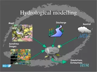
Models used ISBA (Interaction Soil Biosphere Atmosphere) from CNRM (spatial resolution 1°x1°) for lateral inflows + LISFLOOD-FP, flood inundation model from University of Bristol, for the river : Atmospheric input Incoming flow to the study domain Lateral inflow to the river from study domain ISBA LSM Discharge from Belogorje gauging station Runoff from each pixel TRIP Lateral inflow from the whole river basin Flood plain topography LISFLOOD Manning coefficients (friction) for river and flood plain River centre, width anddepth Discharge, water depth and elevation (river & flood plain) River modelling
Lower Ob (between Belogorje and Salkhard): Study domain 8 7 Legend: Incoming flow (Belogorje) Lateral inflow (ISBA) River (CIA WDB) Gauging station 6 5 4 3 2 1 Time period: year 1993 (daily discharge at Belogorje only available from 01/01/1993 to 10/31/1994)
Modelled discharge • Comparison between modelled and measured discharge at Salekhard as a function of the river depth (Manning coefficient=0.015): Discharge underestimation (~7000 m3/s) -> too weak lateral inflow (linked with precipitation)
Comparison Topex/modelled height • Comparison between April and October 1993: TopexVirtual station shown River depth=10m & Manning coefficient=0.015 River depth=15m & Manning coefficient=0.015
SWOT simulator • The synthetic SWOT measurement simulator developped by Noveltis for oceans has been adapted for hydrology: Instrument ground location: Orbit Parameters Instrumental Error (Gaussian noise) Synthetic SWOT measurement Nadir/wide swath selection Water elevation at the measurement points Water elevation:
Assimilation • Use of an Ensemble Kalman Filter to assimilate the synthetic SWOT observations into LISFLOOD. • Model uncertainties represented through an ensemble of model states, generated by perturbing: • 1. Precipitation (rain+snow), • 2. Air temperature, • 3. River depth+flood plain topography, • 4. Manning coefficient. • Different Orbits can be tested. It will also be possible to assess how SWOT will improve the modelling compared to the use of only nadir data.