Download

1 / 1
10 likes | 150 Vues
A Preliminary Observational Study of Hurricane Eyewall Mesovortices. A Preliminary Observational Study of Hurricane Eyewall Mesovortices. A BSTRACT

E N D
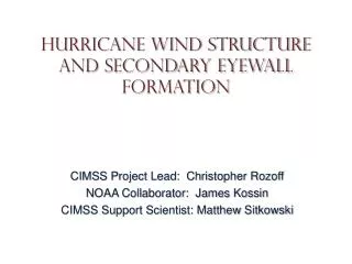
A Preliminary Observational Study of Hurricane Eyewall Mesovortices A Preliminary Observational Study of Hurricane Eyewall Mesovortices ABSTRACT The observational study of fine-scale features in the eye and eyewall of intense tropical cyclones (TC) has been made possible with high temporal and spatial resolution imagery from geosynchronous satellites. The current Geosynchronous Operational Environmental Satellite (GOES) Series is capable of producing 1-km resolution visible images every minute, resulting in an immense dataset which can be used to study convective cloud tops as well as transient low-level cloud swirls. Computer models have shown that vorticity redistribution in the core of a TC can result in the formation of local vorticity maxima, or mesovortices. Some models (Kossin and Schubert, submitted) have also suggested that this process is responsible for polygonal eyewalls and in some instances, rapid intensification. Satellite imagery has proven valuable in the “validation” of the model results, indicating that perhaps there is some hope of understanding the inner core of tropical cyclones. Visible satellite imagery will be used to demonstrate the life cycle of these meso-vortices and show how they influence cyclone intensity. ALBERTO, 12Aug00 (1445Z-1915Z) BRET, 22Aug99 (1845Z-2010Z) 1445Z 1615Z 1745Z 1915Z During this 4.5 hour interval, MSW were 110kts with a MSLP of 950mb… a Category 3 hurricane on the Saffir-Simpson Scale. Relevant features: irregular and transient eyewall shapes observed toward the end of a significant intensification period. The transience of the eyewall features suggests there is abnormally complex vorticity mixing occurring as the young intense hurricane battles for equilibrium. 1845Z 1911Z 1941Z 2010Z During this 85-minute interval, the maximum sustained winds (MSW) were 120kts with a minimum sea level pressure (MSLP) of 945mb… a Category 4 hurricane on the Saffir-Simpson Scale. Lines were subjectively drawn on the images to bring out the relevant features: a pentagonal eyewall (wavenumber-5 instability), in Frames 1 and 2, a vortex merger between Frames 2 and 3 resulting in a square eyewall, then a vortex crystal (a polygonal eyewall rotating as a solid body; e.g. Fine 1995, Schecter 1999) in Frames 3 and 4. FLOYD, 12Sep99 (1845Z-2002Z) ISAAC, 28Sep00 (1445Z-1915Z) REFERENCES Fine, K.S., A.C. Cass, W.G. Flynn, and C.F. Driscoll, 1995: Relaxation of 2D Turbulence to Vortex Crystals. Physical Review Letters, 75, 3277-3280. Kossin, J.P. and W.H. Schubert: Mesovortices, Polygonal Flow Patterns, and Rapid Pressure Falls in Hurricane-Like Vortices. Submitted, Journal of the Atmospheric Sciences. Montgomery, M.T., J.M. Hidalgo, and P.D. Reasor, 2000: A Semi-spectral Numerical Method for Modeling the Vorticity Dynamics of the Near-core of Hurricane-like Vortices. Atmospheric Science Paper, Dept. of Atmospheric Science, Colorado State University. Schecter, D.A., D.H.E. Dubin, K.S. Fine, and C.F. Driscoll, 1999: Vortex Crystals from 2D Flow: Experiment and Simulation. Physics of Fluids, 11, 905-914. Schubert, W.H., M.T. Montgomery, R.K. Taft, T.A. Guinn, S.R. Fulton, J.P. Kossin, and J.P. Edwards, 1999: Polygonal Eyewalls, Asymmetric Eye Contraction, and Potential Vorticity Mixing in Hurricanes. Journal of the Atmospheric Sciences, 56, 1197-1223. 1845Z 1902Z 1932Z 2002Z During this 77-minute interval, MSW increased from ~105kts to ~110kts while the MSLP decreased from ~955mb to ~940mb; this transition is about midway through a rapid intensification in which the pressure fell 40mb in 24 hours. Relevant features: wavenumber-5 instability resulting in a pentagonal eyewall rotating as a vortex crystal. 1445Z 1615Z 1745Z 1915Z During this 4.5-hour interval, MSW increased from 105kts to ~120kts while the MSLP fell from 956mb to ~943mb… an example of rapid intensification. Relevant features: symmetric eyewall in Frame 1, formation of mesovortices and pentagonal eyewall by Frame 2, vortex merger between Frames 2 and 3 to create a square eyewall in Frame 3, then evidence of a vortex crystal and eyewall contraction in Frame 4. ACKNOWLEDGEMENTS This research is supported by the US Department of Defense Center for Geosciences/Atmospheric Research (Agreement DAAL01-98-2-0078). Special thanks to Jim Kossin, Wayne Schubert, Mike Montgomery, and Tom Vonder Haar at Colorado State University for their input, suggestions, comments, and support. Brian D. McNoldy and Thomas H. Vonder Haar Department of Atmospheric Science, Colorado State University e-mail: mcnoldy@cira.colostate.edu SATELLITE OBSERVATIONS A series of recent case studies will be presented that demonstrate the existence of mesovortices, vortex mergers, polygonal eyewalls, and vortex crystals. All cases were collected from the GOES-8 geosynchronous satellite centered over 0°N 75°W. Some cases were taken from “Normal Operations”, meaning images are taken every 15 or 30 minutes (depending on location). In special cases, the satellite images the storm every seven minutes; this is called “Rapid Scan Operations”. Finally, in high-priority situations, images can be taken every minute; this is called “Super Rapid Scan Operations”. To view loops of all the cases using the highest temporal resolution available, visit http://thor.cira.colostate.edu/tropics/eyewall/. The following four cases are small excerpts from the full loops. MODEL COMPARISON The following model results were produced from a 2D barotropic model in which thin rings of enhanced vorticity were embedded in nearly irrotational flow (from Kossin and Schubert, submitted). Similar modeling studies were performed by Schubert et al (1999) and Montgomery et al (2000), but were not able to produce the vortex crystal behavior seen here. The top row of figures are plots of vorticity (z) and horizontal wind (v) in a modeled hurricane-like vortex. The bottom row of figures are plots of pressure perturbation (p*) and streamfunction (y) in the same vortex. Initial conditions for this model run: z1 = 0 s-1 r<RMW z2 = 243 x 10-4 s-1 r=RMW z3 = 0 s-1 r>RMW p* = -14.3 mb RMW = 15 km vMAX = 44 m s-1 The panels show the vortex at times 0.00h, 0.45h, 3.5h, and 24.00h after initialization. Final conditions for this model run: p* = -26.7 mb RMW = 15 km vMAX = 46 m s-1 The top row shows how a uniform ring of vorticity can break down into mesovortices when embedded in an environment not unlike that of an intense or intensifying hurricane. The meso-vortices undergo merger processes after several hours and can exist in asymmetric quasi-equilibrium as a vortex crystal. The bottom row shows how the mesovortices create coincident mesolows and how the stream-function (parallel to velocity vector) follows polygonal trajectories around the eyewall. AGU 2000 Fall Meeting ~ San Francisco, CA ~ December 17, 2000 A72E-03