Download
1 / 17
180 likes | 202 Vues
Learn about the EN14614:2004 standard for evaluating river hydromorphological features, survey requirements, channel, bank, and floodplain features, training manuals, and using the standard in the UK/WFD context. Discover the importance of standard approaches in river habitat quality assessments. Developed through expert workshops, this standard serves as a diagnostic tool for river management and restoration work.

E N D
RIVER HYDROMORPHOLOGY EN 14614: GUIDANCE STANDARD FOR ASSESSING THE HYDROMORPHOLOGICAL FEATURES OF RIVERS
BACKGROUND • Hydromorphological assessment in rivers a relatively new discipline • Techniques have been developed for rivers in a few countries (especially UK, Germany, France, Austria)
PROCESS • Work began following the CEN meeting in Peniche, 1998 • Series of workshops, including field workshop comparing national methods • Standard published in November 2004
OUTLINE OF STANDARD ON RIVER HYDROMORPHOLOGY • Guidance standard • Follows same general layout of all CEN standards • Not intended as a detailed handbook of hydromorphology - guidance on how to apply a standard approach to hydromorphological assessment by using existing national methods or by developing new ones
CONTENT OF STANDARD • Introduction, Scope, Definitions, Principle • Survey Requirements • River types • Dividing rivers into reaches • Survey strategy • Scale of surveys and evaluations • Timing and frequency of field surveys • Reference conditions
OUTLINE OF STANDARD • Features for survey and assessment • Standard suite of features • Feature recording related to purpose and method of data gathering • Field survey procedure • Classification and reporting based on hydromorphological assessment
OUTLINE OF STANDARD • Data presentation • Quality assurance • Training and quality assurance for survey and assessment • Training manuals • Data entry and validation • Bibliography
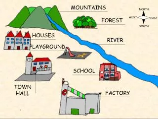
CHANNEL FEATURES 1. Channel geometry 2. Substrates 3. Channel vegetation and organic debris 4. Erosion/deposition character 5. Flow 6. Longitudinal continuity as affected by artificial structures
RIVER BANK AND RIPARIAN ZONE FEATURES 7. Bank structure and modifications 8. Vegetation type/ structure on banks and adjacent land
FLOODPLAIN FEATURES 9. Adjacent land-use and associated features 10. Degree of (a) lateral connectivity of river and floodplain; (b) lateral movement of river channel
USE OF STANDARD IN UK • Principles followed in identifying river reference conditions • Regulatory standards – in accordance with CEN standard
RIVER HABITAT QUALITY ASSESSMENT WORK IN PROGRESS
PURPOSE • WFD does not require hydromorphological quality classification • This proposed standard seen as an adjunct to WFD assessments • Aims to provide a standard, high-level, pan-European technique for river habitat quality assessment
Introduction The assessment of river ‘quality’ in Europe has evolved over the past 20 years. From its original focus on organic pollution it now relies on methods for analysing a range of chemical and biological attributes. More recently, several European countries have developed systems for evaluating the hydromorphological features of rivers. The EC Water Framework Directive (WFD) has reinforced the need for this broader view of river ‘quality’ through its requirement for determining ‘ecological status’ based on macrophytes, phytobenthos, invertebrates and fish, supported by a range of hydromorphological and physicochemical descriptors. Publication of a Guidance standard for assessing the hydromorphological features of rivers (EN14614:2004) contributes both to the WFD, and to other aspects of river management, by describing a protocol for physical habitat assessment. However, there is also a need for standard approaches to assessing the quality of hydromorphological features. The standard described here has been designed to meet this need, and has applications for broadscale hydromorphological assessment as a diagnostic tool under the WFD, land-use planning and strategic environmental assessment, catchment appraisals for catchment management, and setting targets for river restoration work.
PROCESS • Principally developed by a series of expert workshops (Vienna, Cardiff, Helsinki, Milan, Lyon in April 2006) • Main involvement from UK, Germany, Austria, with input from Italy and Finland (+France)
SCOPE AND CONTENT • Scope, terms and definitions, principle • Feature categories • Scoring and weighting • Assigning classification terms (e.g. ‘near-natural’, ‘severely altered’) • Annex – protocol for scoring
PROSPECTS • Following Lyon workshop (April 2006), revised text presented to TG 5 (June 2006) • Propose to ask for a ‘work item’ and then to proceed to informal consultation