Download
1 / 38
440 likes | 760 Vues
Introduction hydrologic and hydraulic modelling using MIKE11 (NAM and HD). Gennadiy Donchyts UCEWP, Kiev. Contents. NAM model overview HD model overview Building model, calibration and verification Hydro-meteo (Q, h, P, T, E) Cross-sections (distance, accuracy, source data)

E N D
Introduction hydrologic and hydraulic modelling using MIKE11 (NAM and HD) Gennadiy Donchyts UCEWP, Kiev
Contents • NAM model overview • HD model overview • Building model, calibration and verification • Hydro-meteo (Q, h, P, T, E) • Cross-sections (distance, accuracy, source data) • Structures (bridges, weirs, gates, reservoirs, etc.) • Additional data (DEM/DTM, TIN, Vector, Satellite, Aerial) • Calibration and verification process • Example flood-related projects in Transcarpathia
NAM HD Processes that can be simulated by MIKE11
Hydro and morphological data used for the rainfall-runoff model customization
NAM – introduction • NAM model is deterministic, lumped, conceptual model • NAM is a set of linked mathematical statements describing the behaviour of the land phase of the hydrological cycle
Structure of NAM model • Snow storage • Surface storage • Lower and root zone storage • Groundwater storage
Data requirments • Model parameters • Initial conditions • Meteorological data • Hydrological data
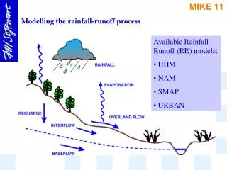
Hydrologic and meteorological data for NAM • Rainfall (mm) • Potential evapotranspiration (mm) • Temperature (Co) • Discharge (m3/s) • Water level (m)
Mike11 calibration. NAM model • 9 subcatchments • Uzh – 4 subcatchments • Latoritsa – 5 subcatchments
Uzh River calibration, 1998 Zhornava 550 km2 Zaricheve 1280 km2 Uzhgorod 1970 km2
Mike11 HD model • MIKE 11 is a hydrodynamic model that computes unsteady flows in river and estuaries. • Sev-Venan equations • Mass balance • Momentum balance
Data requirments • Model parameters • Initial conditions (Q, h) • Boundary conditions (Q, Q/H) • Lateral inflow (NAM results • Hydraulic structures data
MIKE11 customisation • Preparation of data in the MIKE11 files format • Hydrodynamic model setup (HD river network schematization) • Model calibration and validation
Mukachevo Nelipine NAM Rainfall-Runoff model validation
Mike11 calibration Latoritsa Dyke breaks occurred Polders were used Not enough Too much
Slatina Stara Charonda-Latoritsa Visokoberezhniy Storage channel