Understanding Weather, Climate, and the Five Themes of Geography
This text explores the fundamental concepts of weather and climate, highlighting essential geographical themes. It covers the basics of geography, such as location (absolute and relative), place (physical features and cultural characteristics), region (similarities and differences), human-environment interaction, and movement of people and goods. Additionally, it discusses natural disasters, including earthquakes, volcanoes, hurricanes, tornadoes, blizzards, and droughts, alongside methods of mapping the Earth and understanding water distribution and landforms.

Understanding Weather, Climate, and the Five Themes of Geography
E N D
Presentation Transcript
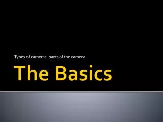
The Basics Unit One Weather, Climate, 5 Themes
The Nitty Gritty: Need to Know Terms • Geography: The study of how humans interact with the physical features of the earth. Prime Meridian Longitude Tropic of Cancer Latitude Tropic of Capricorn Latitude Equator Latitude
The 5 Themes of Geography • Location • Whereisit? • Absolute Location: Exactlywhereitis on earth – latitude and longitude cordintates. • Relative Location: Describes a place in comparison to places aroundit…next to the bigred barn
The 5 Themes of Geography • Place • Whatisitlike? • Physicalfeatures, cultural characteristics, climate, landforms, vegetation…all thatmakethem unique fromother places.
The 5 Themes of Geography • Region • How are places similar or different? • Characteristicsthatunify areas together • Physical • Political • Economic • Cultural • Example: Midwest in the United States
The 5 Themes of Geography • Human-Envrionmental Interaction • How do people relate to the physical world? • How do youractivities change witheachseason?
The 5 Themes of Geography • Movement - How Do People, Goods, and Ideas Get from One Place to Another? • Geographers use three types of distance to analyze movement: - linear distance - time distance - psychological distance
Natural Disasters The Earth Trembles • An earthquake occurs when plates grind or slip at a fault line • A seismograph detects earthquakes and measures the waves they create Earthquake Locations • Location in the earth where an earthquake begins is called the focus • Epicenter—the point directly above focus on the earth’s surface • Nearly 95% of earthquakes occur at tectonic plate boundaries
Natural Disasters The Explosive Earth • Volcano—underground materials pour from crack in the earth’s surface • Most volcanoes occur at tectonic plate boundaries Volcanic Action • Eruption—lava, gases, ash, dust, explode from vent in Earth’s crust • Lava—magma that has reached the earth’s surface; may create landform
Natural Disasters Hurricanes • Huge storms called hurricanes, or typhoons in Asia: - form over warm, tropical ocean waters - hit land with heavy rain, high winds, storm surge Tornadoes • Tornado—a powerful, funnel-shaped column of spiraling air: - born from strong thunderstorms - capable of immense damage
Natural Disasters Blizzards • Blizzard—heavy snowstorm with strong winds, reduced visibility Droughts •Drought: long period of time with either no or minimal rainfall Floods • Water spreads out over normally dry land
How do we “map” the Earth?? • Two or Three Dimensions • Globe—athree-dimensional representation (a sphere) of Earth • Map—a two-dimensional graphic representation of Earth’s surface • Cartographer(mapmaker) tries to accurately reflect earth’s surface • Mapprojection—way of showing Earth’s curved surface on a flat map • Surveying • Surveyors observe, measure, record what they see in a specific area • Remote sensing, gathering geographic data from a distance, includes: • aerial photography • satellite imaging • Geographic Information Systems (GIS) is a digital geographic database
How does Weather occur?? Ocean Motion • The ocean circulates through currents, waves, tides • Currents act like rivers flowing through the ocean • Waves are swells or ridges produced by winds • Tides are the regular rising and falling of the ocean • created by gravitational pull of the moon or sun • Motion of ocean helps distribute heat on the planet • winds are heated and cooled by ocean water Water, it’s EVERYWHERE! Lakes hold more than 95% of the earth’s fresh water • Ground water—water held in the pores of rock • Water table—level at which the rock is saturated
Onto the Dry Part of the Planet… Landforms • Landformsarenaturally formed features on Earth’s surface • Tectonic platesare massive, moving pieces of Earth’s lithosphere Plate Movement • Plates move in a few ways: • by spreading, or moving apart • subduction, or diving under another plate • collision, or crashing together • sliding past each other in a shearing motion
How Does Earth Change?? Altering the Landscape • Weathering—processes that alter rock on or near the earth’s surface • Mechanical weathering—processes that break rock into smaller pieces • Does not change rock’s composition, only size • Examples: frost, plant roots, road construction, mining • Chemical weathering—interaction of elements creates new substance • Example: when iron rusts it reacts to oxygen in air and crumbles • Erosion—when weathered material moves by winds, water, ice, gravity