Download
1 / 57
570 likes | 729 Vues
WHG Era 2 – Early Civilizations and Cultures and the Emergence of Pastoral Peoples, 4000 to 1000 BCE Part Two. WHGCEs Middle School Series Session 7. Craig Benjamin. Why is geography so important to early Indian history?. Which were the first dynasties in early China?.

E N D
WHG Era 2 – Early Civilizations and Cultures and the Emergence of Pastoral Peoples, 4000 to 1000 BCE Part Two WHGCEs Middle School Series Session 7. Craig Benjamin Why is geography so important to early Indian history? Which were the first dynasties in early China? How did Indian and Chinese history unfold between 4000 and 1000 BCE?
W2.1 Early Civilizations and Early Pastoral SocietiesAnalyze early Eastern Hemisphere civilizations and pastoral societies • During this era early civilizations and pastoral societies emerged. Many of the world’s most fundamental institutions, discoveries, inventions, and techniques appeared. Pastoral societies developed the herding of animals as a primary food source that enabled them to inhabit the semi-arid steppes of Eurasia and Africa. • This era introduces students to one of the most enduring themes in history: the dynamic interplay, between herding and agrarian societies involving both conflict and mutual dependence.
Analyze early Eastern Hemisphere civilizations and pastoral societies contd. 7 – W2.1.1Development of human language, oral and written, and its relationship to the development of culture • verbal vocalizations • standardization of physical (rock, bird) and abstract (love, fear) words • pictographs to abstract writing (governmental administration, laws, codes, history and artistic expressions) 7 – W2.1.2 Use historical and modern maps and other sources to locate, describe, and analyze major river systems and discuss the ways these physical settings supported permanent settlements, and development of early civilizations • Tigris and Euphrates Rivers (Done in Session 6) • Nile River (Done in Session 6) • Yangtze River (This Session) • Indus River (This Session)
Analyze early Eastern Hemisphere civilizations and pastoral societies contd. 7 – W2.1.3 Examine early civilizations to describe their common features (ways of governing, stable food supply, economic and social structures, use of resources and technology, division of labor and forms of communication) 7 – W2.1.4 Define the concept of cultural diffusion and how it resulted in the spread of ideas and technology from one region to another (e.g., plants, crops, plow, wheel, bronze metallurgy) 7 – W2.1.5Describe pastoralism and explain how the climate and geography of Central Asia were linked to the rise of pastoral societies on the steppes.
Part One: The Geographical and Cultural Background to Indian Civilization • ‘Greater India’ shaped like a diamond jutting southwards into the Indian Ocean • N. India and Pakistan hemmed in by the highest mountain ranges on Earth - Himalayas and Karakoram – divide subcontinent from the rest of Asia • Across a very few passes through these mountains (like the Khojack, Khyber and Khunjerab) a series of migrating peoples, armies, traders, merchants and travelers came to shape Indian history
Hindustan and the Deccan • India also dominated by two other distinct geographical regions: 1. In the north is the ‘Great Plain’ (or Hindustan – ‘land of the Indus peoples’) – stretches from the Indus Valley to the Bay of Bengal • Contains the vast river systems of the Indus and Ganges 2. In the south (separated by the Vindhya Mountains) is a semi-arid plateau known as the Deccan (‘southland’) Deccan Plateau from Space
Indian Climate • Climate governed by winds: • Dry northeast monsoon winds of winter (which blow down from the arid heart of Central Asia) • Wet southwest monsoon winds of summer (which blow up from the Indian and Arabian Seas) • Most rain falls in the summer and autumn, brought in by winds from the Arabian Sea • Western Ghats receive heavy summer rains - one of the wettest places on earth • The Deccan is very dry Monsoon rains in Calcutta www.bbc.co.uk The arid Deccan Plateau www.nationalgeographic.com
Languages and Ethnicity • Two major language groups: • Indo-European peoples in the north (Aryan migrants who arrived in India during the 2nd millennium BCE) • Dravidians in the south (original occupants of India before the Aryan invasions) • Despite this linguistic and ethnic division, between 1500 BCE and 300 CE the adoption of Hindu religion gave all of India an cultural unity, similar to that achieved in Europe by Christianity
Early History • Archaeology shows that humans lived in India during the Paleolithic Era as foragers • By 7000 BCE agriculture was practiced in the Indus Valley, spreading to the south • By 3000 BCE Dravidians had established agricultural communities all over India • Crops grown were wheat barley and cotton; domesticated animals included cattle, sheep and goats • Successful agriculture meant increased populations and the emergence of towns, cities and states • The earliest urban civilization was that of the Harappans, in the Indus Valley
Part Two: The Indus Civilization(c2500-1500 BCE) • Indus Valley consists of rich upper alluvial plain called the Punjab (‘land of five waters’) and a drier lower Indus region called Sind (sindhu = river) • From Sind come the terms Hindu and India • Indus draws its waters from snow melt in the Hindu Kush and Himalayas • Carries huge quantities of silt that are deposited lower down the valley • Today a series of dams has tamed the Indus, but for most of history it was subject to regular, often devastating floods
Early Indus History • Rise of civilization in the Indus Valley duplicated what happened along Tigris, Euphrates and Nile rivers • Early agrarian communities emerged on the hilly flanks of the rivers • Sowed wheat and barley in September, and harvested in the spring; also grew cotton and dyed it (a textile industry?) • Kept cattle, sheep, goats and the world’s first domesticated chickens
Urban Civilization • As in Mesopotamia and Egypt, agricultural surpluses led to increased populations, and gradually early agrarian communities evolved into more complex state-like structures • The surpluses fed two very large cities – Harappa and Mohenjo-Daro
The Emergence of the Indus Civilization • By 2300 BCE Mohenjo-Daro (in Sind) and Harappa (in the Punjab) had up to 40,000 inhabitants each • Civilization reached its peak c. 2000 BCE: tightly organized urban centers; system of uniform weights and measures; and pottery • Harappan society covered much of modern-day Pakistan and a large part of Northern India – about 502,000 square miles • Therefore much larger than either Mesopotamia or Egypt
The Indus CivilizationMap www.bosei.cc-u.tokai
Indus Cities • Road crews in the 19th century recycled bricks for modern road building, leading to the discovery of the entire civilization • Mohenjo-daro and Harappa (400 miles apart) extensively investigated by archaeologists • Indus River maintained communications and a uniform administration and economy • Well planned cities with straight streets intersecting at right angles • Sophisticated drainage systems with underground channels • Two-storey houses constructed of strong baked bricks Drainage system at Harappa www.voi.org/michael Harappa www.bufferstock.org
Indus Economy • Economy based on irrigation agriculture: state collected surpluses through taxes and stored them in huge granaries • Venus figurines representing fertility found at Indus sites, indicating importance of the harvest, and interstate contacts that existed with the civilizations of SW Asia (pictured above) • Evidence that trade was well-organized: regular contacts with Mesopotamia from as early as the era of Sargon of Akkad (2300 BCE)
Specialized Labor and Trade • Pottery, tools and decorative items produced in Harappa and Mohenjo-daro exported all over the Indus Valley • From Persia they imported gold, silver, lead and gems • With the Mesopotamians (between 2300 and 1750) they traded copper, ivory and pearls for Sumerian wool, leather and olive oil • Some trade went by land over the Iranian plateau; but most by sea on ships following the coastline of the Arabian Sea Modern dhow follows the coast of the Arabian Sea www.martinguilfoyle.250x.com
Indus Society • Indus writing script (400 pictographic signs) has never been deciphered • Indus stamps depict naturalistic animals, but also horned humans, unicorns and other large figures that might be gods • Used bronze smelting to manufacture tools and weapons • Very few weapons found – perhaps they were a peaceful people
Social Distinctions • Wealth of the Indus civilization encouraged the emergence of social classes • Harappan dwellings show that rich and poor lived very different lives • Many poor lived in one room tenement structures • But there are also large houses (2 and 3 stories) with a dozen rooms and multiple courtyards • All houses had private bathrooms with showers and toilets that drained into the city sewerage system Models wearing clothing of Indus Civilization elites
Harappan Religion • Religion reflected a strong concern for fertility • Like other agricultural societies, Harappans venerated gods and goddesses associated with procreation • They had a mother goddess and a horned fertility god • Many believe Harappan gods survived the collapse of the Indus Civilization and were transformed into the Hindu pantheon (in which fertility and procreation are also prominent) www.yogajournal.com Early depiction of Yogic Position – Seal from Mohenjo-daro
The Decline of the Indus Civilization Environmental Degradation • Excavations at Mohenjo-daro show that decline set in after c.1900 BCE when earthquakes and floods altered the course of the Indus, and the climate changed • Harappans had deforested the Indus valley to clear land for farming, and for firewood, leading to erosion and a gradual climate change • Over half a millennium much of the region became a desert, and agriculture is impossible there today • This meant Harappans faced a subsistence crisis from about 1900 • By about 1700 Harappa and Mohenjo-daro had been abandoned; by 1500 all Indus cities had been abandoned
Aryan Invasions? • Soon after (from c.1500) as Indus Civilization declined, bands of Indo-European-speaking migrants from the north began to move into the Indus Valley from the Iranian Plateau • Their role (if any) in the collapse of the Indus Civilization is not clear; by no means was this an organized military invasion, but a gradual migration, including much intermarrying with the locals • The Indo-European invaders are known today as the Aryans • Rapidly became the dominant group in Pakistan and North India, but they also assimilated ideas and technologies from the Indus peoples • The culture and Vedic religion of these migrants (cultivated by their priests and religious rulers called Brahmins) became the foundation for the subsequent history of India
Indo European Migrations: Map www.mit.edu/afs/athena
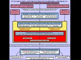
Part 3: Early Chinese History • Early Chinese history follows similar pattern to other parts of Eurasia • Humans migrated to East Asia 100,000 years ago - lived as hunter gatherers • From 7000 BCE population pressure and semi-sedentism led to the adoption of agriculture • Increased resources led to emergence of early states, which were eventually consolidated into huge civilizations that rivaled those in West Asia in terms of their size and power • Our job here is to trace Chinese history from its origins through to the emergence of the first two dynasties – the Xia and Shang
Geographical Background to Chinese History • China lies in the eastern part of Asia, on the west coast of the Pacific Ocean; it is the third largest country in the world • A total land area of 6 million square miles. Distance from east to west is over 3,200 miles, and from north to south, over 3,300 miles • Land border 13,500 mls Bordered by 12 countries - Korea in the east; Russia in the northeast and northwest; Mongolia in the north; India, Pakistan, Bhutan and Nepal in the west and southwest; Burma, Laos and Vietnam in the south
Oceans • China also has extensive neighboring seas and numerous island • Coastline extends more than 9000 miles • Across the East China Sea to the east, and South China Sea to the southeast, are Japan, the Philippians, Malaysia, and Indonesia • More than 5,000 islands are scattered over China's vast territorial seas – largest is Taiwan • China’s seas altogether constitute 2.9 million square miles
Mountains • China a mountainous country, with two-thirds of its total land area covered by mountains, hills and plateaus • Out of the world's 14 high peaks of over 8,000 meters, seven are located in China • The Highest peak in the world, Mount Qomolangma (8,828m) – known as Mt. Everest in the west - stands on the border between China and Nepal • There are five major mountain systems in China which, together with numerous intermontane plateaus, basins, and plains are interwoven into three macro landform complexes in China • So the topography of China from the Qinghai-Xizang Plateau eastward, is broadly arranged into four great steps descending step- by-step from the Qinghai – Tibet Plateau to the coastal area in the east
China’s Wild West • China’s west consists of mountains, deserts and plateaus, which does not provide much arable land for agriculture • So Chinese civilization mainly emerged in the more arable east, meaning that early Chinese culture was ‘isolated’ by the wild west from competing civilizations • But although the mountains and deserts of the west limited contact between early imperial dynasties and other centers of civilization in Inner Asia, the Middle East, South Asia, and Europe, there were some important and notable cultural exchanges (particularly along the Silk Roads)
Two Mighty Rivers • Overall, Chinese subcontinent contains at least 8 different ecosystems – from semitropical southeast (4 feet of rain per year) to arid north (less than 4 inches) • Chinese geography has determined the emergence of human history, and has been responsible for dividing Chinese culture into two distinctive regions • This is because China is dominated by two vast river systems: both have their source in the high Tibetan Plateau – the Huanghe and Yangzi
The Huanghe (Yellow River) • Called ‘Yellow’ River because of huge amounts of silt (loess) it carries to the sea • So much loess suspended in the river it turns yellow - has the consistency of soup • Rises in the mountains of Tibet and flows for 2920 miles to the Yellow Sea • Crosses western high plateau, and flows through the arid northern deserts before spilling out onto a broad northern alluvial plain • Also known as ‘China’s Sorrow’ because of the misery its devastating floods have caused the Chinese people
The Chang Jian (Yangzi River) • Yangzi River also flows from Tibetan Plateau through huge gorges with cliffs up to 1000 feet on its way to the sea • Many of these gorges will be flooded later this year as a result of the massive ‘Three Gorges Dam’ project. Gorges on the Yangtzewww.pbs.org South of the Yangtze Valley are the rice and tea-growing regions of south China
The Neolithic Age (c. 7000 – 1027 BCE) • Archaeological evidence shows that various Chinese communities had adopted agriculture by at least 6,500 BCE • Climate and geography dictated the different crops grown: - Mainly millet and other grains along the Huangho Valley in the north - Rice along the Yangtze Valley in the south. • Early agricultural communities also domesticated the horse, pig, chicken and silk worm
Neolithic Sites • Oldest cultural traces where Chinese cultivated plants and domesticated animals found in Cishan and Peiligang • Most important sites in the south, not as old as in the north, are Liangzhu, Majiabang, Hemudu and Qujialing • Although the differences between the pottery decorations and shapes of early cultures are very small (cord marks, shell-edge impressions, vessels with three legs in the north) it is possible to distinguish different regional cultures in China from c 5000 BC
Yangshao and Longshan Cultures • Abundant harvests supported development of several neolithic societies, each with their own distinctive pottery styles • In the north (along the middle Huanghe) the Yangshao culture (5000-3000 BCE) grew millet, used stone tools, raised pigs and chickens, and had a distinctive type of pottery decoration • Entire Yangshao village unearthed by archaeologists in 1952 at Banpo near Xian • By 4000 BCE the subsequent Longshan culture coexisted in the north with other agrarian communities, living in walled cities, but interacting with their neighbors
Nomads and Sedentary Communities • Walled Yangshao and Longshan cities, located along river valleys, provided protection from aggressive nomadic bands who lived in the foothills and used the horse extensively • Town-dwellers made technological advances; nomadic people used sophisticated weapons. • Tension between the two a powerful stimulus for innovation • But the independent nature of these early cultures gave China a sense of fragmentation and disunity • Threat of nomadic invasion from the north remained a defining characteristic of the Chinese psyche for millennia
Part Four: The Xia and Shang Dynasties (c. 2100 – 1000 BCE) First dynasty to gain widespread power in northern China was the semi-mythical Xia, tribal rulers who may have controlled the region from late in the third millennium until the late-17th C BCE The Xia were followed by the Shang, who ruled until c1000 BCE, and for whom we have far more evidence
The Xia Dynasty Until 40 years ago, the Xia Dynasty was thought to be a part of a myth that the Chinese told as part of their creation legend. The Xia Dynasty existed in oral histories only - no archaeological evidence for it was found until 1959. But in that year excavations at Erlitous, in the city of Yanshi, uncovered what was most likely a capital of the Xia Dynasty. The site proved that these people were predecessors of the Shang Radiocarbon dates from this site indicate that they existed from 2100 to c.1700 BCE Jade Axe Head, Erlitous c. 2000 BCE
The Wei River Valley, center of Xia Culture • Despite this archaeological evidence, however, the Xia are not universally accepted as a true dynasty • The Xia were agrarian people, with bronze weapons and pottery Xia Lifeway • Ruling families used elaborate and dramatic rituals to confirm their power to govern • Rulers often acted as shamans, communicating with spirits for help and guidance Xia Ornamental Bronze Urn, Erlitous c. 1900 BCE
Archaeological Evidence • Archaeologists have uncovered urban sites, bronze implements, and tombs that point to the possible existence of the Xia dynasty at locations cited in ancient Chinese historical texts • But there still exists a debate as to whether or not Erlitou culture was the site of the Xia dynasty • Radiocarbon dating places the site at ca. 2100 to 1700 BC, providing physical evidence of the existence of a state contemporaneous with and possibly equivalent to the Xia Dynasty as described in Chinese historical works • In 1959, a site located in the city of Yanshi was excavated containing large palaces that some archaeologists have attributed as capital of the Xia Dynasty • Though later historical works mention the Xia dynasty, no written records dated to the Xia period have been found to confirm the name of the dynasty and its sovereigns
The Shang (c. 1600-1030 BCE) • Xia were replaced by the Shang Dynasty in c. 1600, which ruled in the north for the next 600 years • Shang responsible for the development of writing, a more complex social structure and the first large cities • Shang kings had enormous power, and controlled armies of laborers and craftsmen which they used to construct monumental tombs and palaces Shang Bronze Urn
Discovery of the First True Dynasty? • So it is the Shang, rather than the Xia, that is considered by many to be the first true dynasty of China • Like the Xia, the Shang were originally considered to be a myth • They were discovered because Chinese pharmacists were selling oracle bones the Shang had created • Bones first noticed in 1899 and by the 1920's were traced to Anyang, where the last Shang capital was found and excavated • In the 1950's an earlier Shang capital was found near present day Zhengzhou • Traditional accounts suggest that the Shang Dynasty consisted of 30 kings and seven different capitals • The Zhou dynasty that followed the Shang are responsible for the recordings of the kings and capitals of the Shang Dynasty Shang Supreme God, Di
Shang Cities • Shang kings extended their rule to a large portion of NE China • Used tribute and resources from surplus agricultural production to construct cities • Shang cities large and walled – used to demand tribute from other tribal leaders • Shang capital moved six times in 600 years; one capital was Ao near Zhengzhou – walls 33 feet high and 66 feet thick at the base (still 13 feet high today) Ruins of Ao today
Anyang • Most famous capital was Yin near modern Anyang, where the production of bronze objects demonstrates Shang wealth and technical skill • Bronze metallurgy may have arrived in China with early Indo-European migrants via Central Asia (disputed by Chinese archaeologists) www.mishalov.com/ korean-japanese-photos.html www.rom.on.ca/ rombooks/anyang.php
Shang Bronze Artifacts • Chinese metallurgy was sophisticated, and bronze was used to make elaborate ceremonial and drinking vessels, works that were both practical and artistic Main Shang Archaeological Site at Anyang – www.pitt.edu Shang Ritual Bronze Vessals Metropolitan Museum of Art www.acs6.brooklyn
Historiography of Bronze Metallurgy in China • Probably a number of early centers of bronze technology, but the area along the Yellow River in present-day Henan Province emerged as the center of the most advanced and literate cultures of the time and became the seat of the political and military power of the Shang dynasty • There is still uncertainty as to when metallurgy began in China • Most Chinese scholars believe that early bronze working developed autonomously, independent of outside influences • Other western scholars have argued that bronze metallurgy was brought to China from the west by nomads • The era of the Shang and the Zhou dynasties is generally known as the Bronze Age of China, because bronze, an alloy of copper and tin, used to fashion weapons, parts of chariots, and ritual vessels, played an important role in the material culture of the time
As early as 1500 BCE the early Shang Dynasty engaged in large-scale production of bronze-ware vessels and weapons • Production required a large labor force to handle mining, refining, and transportation of copper, tin and lead ores. Shang court and aristocrats required a huge amount of different bronze vessels for various ceremonial purposes and events of religious divination • Led to need for official managers who could provide oversight and employment of laborers and skilled artisans and craftsmen • With the increased amount of bronze available, army also became better equipped with an assortment • of bronze weaponry, and bronze • was also able to furnish the fittings • of spoke-wheeled chariots that • came into widespread use by 1200 Uses and Problems of Bronze
Shang Writing • Shang used an advanced writing system, which they probably inherited from earlier Chinese cultures • Chinese have used same writing system for 3000 years • Uses pictographic characters which stand for individual words rather than sounds; characters based on recognizable representations of everyday objects and ideas, like a table and walking • Later Chinese characters have two parts: one indicates the subject of the word, the second the sound. The character for ‘home’ is a pig under a roof • Chinese Shang writing is the basis for most East Asian writing systems, including Korean and Japanese