Download

1 / 30
300 likes | 379 Vues
Explore terrain visualization challenges and techniques for processing large, complex data sets in environmental monitoring. Learn about LOD algorithms, data structures, and modern approaches for automated information rendering and data processing.

E N D
Issues in Terrain Visualization for Environmental Monitoring Applications Ricardo Veguilla veguilla@ece.uprm.edu Nayda G. Santiago nayda.santiago@ece.uprm.edu Domingo A. Rodriguez domingo@ece.uprm.edu Electrical and Computer Engineering Department University of Puerto Rico, Mayagüez Campus June 23, 2006
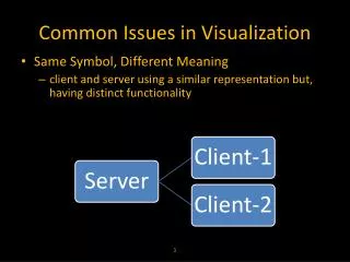
Raw Data Servers Computed Data Servers WALSAIP WALSAIP: Wide Area Large Scale Automated Information Processing INTERNET Data Representation Systems Computational Signal Processing Systems Signal Data Post-processing Information Rendering Systems Signal Conditioning System Sensor Array Structures Pre-processing Stage Processing Stage Post-processing Stage
WALSAIP-VTE (Visual Terrain Explorer) WALSAIP Cyber-Infrastructure Information Rendering System (Visualization) Automated Data Processing Data Acquisition
Data size, complexity, and performance • 3D visualization is computationally expensive • We want to visualize large, complex geometrical models • Critical for interactive terrain visualization due to the sheer size of the data sets
Level of Detail (LOD) • Premise: It is inefficient to use many polygons to render object that will only contribute to a few pixels of the rendered scene. • Conclusion: Use less detail for small, distant portions of the scene. • Approach: Use geometric simplification operations to eliminate redundant information while satisfying both performance and visual accuracy constrains.
Our Goal Review available terrain rendering LOD techniques, with interested in: • How to exploit video card (GPU) processing capabilities • Handling data larger than available memory (out of core, distributed computing) • Identify best approach for a future implementation of the VTE
Basic Components • The initial mesh: A polygonal representation of the terrain at either the minimum resolution level (base mesh) or the maximum resolution level (full mesh) • Updates operations: Operation which simplify or refine a mesh.
Characteristics of LOD Algorithms • LOD Granularity • LOD Distribution • Processing direction • Terrain Data Structure • LOD Data Structure
76 polys 2,502 polys 69,451 polys 251 polys LOD granularity • Discrete LOD: finite set of pre-computed LODs • Continuous LOD: further simplifies discrete LODs to produce a continuous spectrum of detail 251 polys 69,451 polys N polys
LOD distribution • Uniform • View-dependent
Processing direction Top-down (refinement or subdivision algorithm) Bottom-up (simplification or decimation algorithm)
Terrain data structure Height fields (Regular) Triangulated Irregular Networks (Irregular)
LOD data structure Quadtree: a rectangular region recursively subdivided into four uniform quadrants. Bintree (Binary triangle tree) : a rectangular region is recursively subdivided into two triangles.
Approaches • Traditional Approach • 80’s • The basic unit is the triangle • Traditional LOD techniques generally aimed to produce the ideal level of detail • Modern Approach • 2000’s • Basic unit is the triangle cluster or patch • Concerned with maximizing GPU usage and minimizing CPU usage
Real-time, continuous LOD rendering of height fields • Using a quadtree with discrete LODS generated off-line top-down refinement bottom-up simplification
ROAM • Uses two ordered priority queues: one for split operations and the other for merge operations.
View-dependent Progressive Meshes • a TIN-based, view dependent terrain LOD algorithm • Continuous LOD is produce by recursively removing triangles from off-line generated blocks of terrain.
Geometrical MipMapping Quadtree technique that work on blocks of uniform detail Simplification based on vertex removal Selection based on worst-case view parameters Eliminates cracks by changing vertex connectivity at the block boundary
Triangle cluster Techniques • Cluster: small triangle meshes optimized for GPU processing • Cluster are cached on the video card memory. • Hierarchy is used for view culling ACL Frustrum Occluded Cluster Inactive Cluster Visible Cluster Occluded Cluster ACL = Active Cluster List
Geometry Clipmap A multi-resolution mesh formed by combining nested concentric grids center about the view position Resulting view View culling
Conclusions • In Use of triangle cluster patches as basic rendering unit allow: • maximizing GPU usage* • better coupling of the geometry and the texture • out-of-core operation* • The ideal level of detail (an irregular mesh) is in compatible with GPU maximization (which require regular meshes) *points of interest for the WALSAIP-VTE project
LOD and WALSAIP WALSAIP Cyber-Infrastructure Automated Terrain LOD Generation Terrain Visualization Terrain Data Acquisition
WALSAIP-VTE - Status • Java and OpenGL implementation with LOD based on GeoMipMaps. • Future research on out-of-core data management for remote data acquisition
References • Clark, J. H. (1976). “Hierarchical geometric models for visible surface algorithms”. Commun. ACM Vol. 19, No. 10, pp 547-554. • Luebke, D., Reddy, M., Cohen, J., Varshney, A., Watson, B., and Huebner, R. (2003). Level of Detail for 3D Graphics, Morgan-Kaufmann, Los Altos, CA. • Fowler, R. J. and Little, J. J. 1979. (1979). “Automatic extraction of Irregular Network digital terrain models”. Proceedings of the 6th Annual Conference on Computer Graphics and Interactive Techniques. SIGGRAPH '79. ACM Press, New York, NY, pp 199-207. • Samet, H. (1984). “The Quadtree and Related Hierarchical Data Structures”. ACM Comput. Surv. Vol. 16, No. 2, pp 187-260. • Puppo, E.(1998), “Variable resolution triangulations”, Computational Geometry, Vol. 11, No. 3-4, pp.219-238. • Leclerc, Y. G. and Lau, S. Q. (1995). “TerraVision: A Terrain Visualization System”, Technical Note 540. AI Center, SRI International, http://www.ai.sri.com/pubs/files/778.pdf 02/15/2006 • Reddy,M., Leclerc,Y., Iverson,L., and Bletter, N. (1998) "TerraVision II: Visualizing Massive Terrain Databases in VRML," IEEE Computer Graphics and Applications, Vol.19, No.2, pp. 30-38. • Williams, L. (1983). “Pyramidal parametrics”. Proceedings of the 10th Annual Conference on Computer Graphics and interactive Techniques SIGGRAPH '83. ACM Press, New York, NY, 1-11. • Zach, C., Mantler, S., and Karner, K. (2002). “Time-critical rendering of discrete and continuous levels of detail”. VRST ’02: Proceedings of the ACM symposium on Virtual reality software and technology, pp. 1–8. • X. Bao and R. Pajarola, (2003) “Lod-based clustering techniques for efficient large-scale terrain storage and visualization,” Proceedings of the SPIE - The International Society for Optical Engineering, Vol. 5009, pp. 225–35. • Lindstrom, P., Koller, D., Ribarsky, W., Hodges, L. F., Faust, N., and Turner, G. A. (1996). “Real-time, continuous level of detail rendering of height fields”. In Proceedings of the 23rd Annual Conference on Computer Graphics and interactive Techniques SIGGRAPH '96. ACM Press, New York, NY, 109-118. • Röttger, S., Heidrich, W., Slussallek, P., and Seidel, H. P. (1998) “Real-Time Generation of Continuous Levels of Detail for Height Fields”. Proceedings of the 6th International Conference in Central Europe on Computer Graphics and Visualization, 315--322. • Duchaineau, M., Wolinsky, M., Sigeti, D. E., Miller, M. C., Aldrich, C., and Mineev-Weinstein, M. B. (1997). “ROAMing terrain: real-time optimally adapting meshes”. Proceedings of the 8th Conference on Visualization '97. R. Yagel and H. Hagen, Eds. IEEE Visualization. IEEE Computer Society Press, Los Alamitos, CA, 81-88
References (Cont) • Hoppe, H. (1996). “Progressive meshes”. Proceedings of the 23rd Annual Conference on Computer Graphics and interactive Techniques SIGGRAPH '96. ACM Press, New York, NY, 99-108. • Hoppe, H. (1997). “View-dependent refinement of progressive meshes”. Proceedings of the 24th Annual Conference on Computer Graphics and interactive Techniques International Conference on Computer Graphics and Interactive Techniques. ACM Press/Addison-Wesley Publishing Co., New York, NY, pp. 189-198. • Hoppe, H. (1998). “Smooth view-dependent level-of-detail control and its application to terrain rendering”. Proceedings of the Conference on Visualization '98. IEEE Computer Society Press, Los Alamitos, CA, pp 35-42. • De Boer, W. H., (2000). “Fast terrain rendering using geometrical mipmapping”. http://www.flipcode.com/articles/article-geomipmaps.pdf. 02/15/2006 • Brodersen, A. (2005). “Real-time visualization of large textured terrains,” GRAPHITE ’05: Proceedings of the 3rd international conference on Computer graphics and interactive techniques in Australasia and SouthEast Asia, pp. 439–442. • Cignoni, P., Ganovelli, F., Gobbetti, E., Marton, F., Ponchio, F., and Scopigno, R. (2003). “BDAM - batched dynamic adaptive meshes for high performance terrain visualization,” Computer Graphics Forum, Vol. 22 No. 3 pp505-514. • Levenberg, J. (2002) “Fast view-dependent level-of-detail rendering using cached geometry”. VIS ’02: Proceedings of the conference on Visualization ’02. • Yoon, S., Salomon, B., Gayle, R., and Manocha, D. (2005). "Quick-VDR: Out-of-Core View-Dependent Rendering of Gigantic Models," IEEE Transactions on Visualization and Computer Graphics, Vol. 11, No. 4, pp. 369-382. • Zhu. Y (2005), “Uniform Remeshing with an Adaptive Domain: A New Scheme for View-Dependent Level-of-Detail Rendering of Meshes”. IEEE Transactions on Visualization and Computer Graphics Vol. 11, No. 3, pp. 306-316. • Cohen, J., Luebke, D., Duca, N., and Schubert, B. (2003) “GLOD: A geometric level of detail system at the OpenGL API level,” VIS ’03: Proceedings of the 14th IEEE Visualization 2003 (VIS’03), pp. 85. • Losasso, F. and Hoppe, H. (2004). “Geometry clipmaps: terrain rendering using nested regular grids”. ACM Trans. Graph. Vol. 23, No. 3 , pp. 769-776. • Schneider J., and Westermann, R. (2006) “Gpu-friendly high-quality terrain rendering,” Journal of WSCG, Vol. 14, No. 1-3, pp. 49–56.
Questions? • Ricardo Veguilla veguilla@ece.uprm.edu