Download
1 / 26
260 likes | 426 Vues
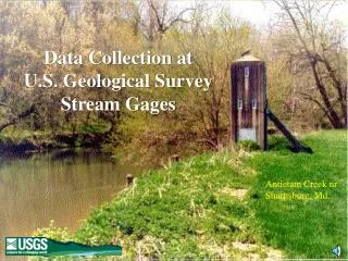
Data Collection at U.S. Geological Survey Stream Gages. Antietam Creek nr Sharpsburg, Md. The first USGS gaging station was established on the Rio Grande near Embudo, New Mexico in 1889. Embudo trainees dispersed to collect data in other locations. Streamflow Measurements in the East. 1889.

E N D
Data Collection at U.S. Geological Survey Stream Gages Antietam Creek nr Sharpsburg, Md.
The first USGS gaging station was established on the Rio Grande near Embudo, New Mexico in 1889.
Embudo trainees dispersed to collect data in other locations
Streamflow Measurements in the East 1889 1994 “Flood Crest March 18, 1936” Potomac River at Chain Bridge nr Washington, D.C. Potomac River at Point of Rocks, Md.
The Embudo LegacyData collected using nationally consistent, prescribed standards
. The U.S. Geological Survey currently collects streamflow data at over 7,000 sites Minebank Run at Loch Raven, Md. Potomac River at Little Falls nr Washington, D.C.
Data from over 18,500 locations can be analyzed with confidence
The basic piece of data collected at gaging stations isstream STAGE (water level)
Stage can be sensed usingSTILLING WELLS Intakes Outside reference gages Little Patuxent River nr Guilford, Md.
Orifice Line Stage can also be sensed usingPRESSURE TRANSDUCERS Gwynns Falls at Washington Blvd. at Baltimore, Md. Orifice Line
Basic Data Recorder Stage is usually: • Measured to an accuracy standard of: • “either 0.01 ft or 0.2 percent of the effective stage being measured” -- Office of Surface Water memorandum 93.07 • Recorded every 15 minutes
Most users of streamflow information need to know the DISCHARGE of the stream
Channel Cross Section Discharge usually measured using the velocity-area method Discharge= Velocity x Depth x Width
Discharge measurements are used to develop rating curves Rating Curve Discharge Measurements
Indirect measurement Discharge measurements during high stages are particularly important
To maintain ratings, discharge must be measured regularly 100 For example: rating changes as channel fills. Stage (ft) 10 1 1 10 100 1000 10000 Discharge (cfs)
Staff gages can be damaged Surveying crew from Utah District Benchmark at a station Datum must be checked regularly Gage houses settle
By local office personnel Jack Doyle Boise Field Office And by national review teams All gaging station data are checked and reviewed regularly
Data from Thomas and Wahl, 1993 Data from USGS gaging stations can be used to meet a variety of needs
Modeling and flood forecasting Current needs Chesapeake Bay inflow Susquehanna River at Conowingo, Md.
Regional relations Long-term needs
Uses of Streamflow Information:Flood Frequency Analysis Rank Year Peak 1 1993 10,500 cfs 2 1995 3,200 3 1988 2,340 4 1989 1,850 5 1997 1,230 6 1990 948 7 1992 550 8 1996 320 9 1991 200 10 1994 163 100-year flood
Data dissemination http://water.usgs.gov http://md.usgs.gov
GOES DOMSAT Data dissemination Hydrologic Stations User Operations Wallops, Virginia Command and Data Acquisition Center ( Internet ) Stage http://water.usgs.gov
Acoustic doppler current profiler being used in Idaho Post-mounted gage house and sattelite antenna Aquacalc being used to collect discharge information USGS continues to pursue use of new technology