Download
1 / 8
80 likes | 164 Vues
Explore the intricate exchanges in the Arctic through an innovative observational network focusing on Davis and Fram Strait. The project entails technology development, acoustic communications, and data collection to unlock crucial insights into ocean circulation and freshwater distribution in the region.

E N D
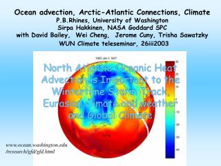
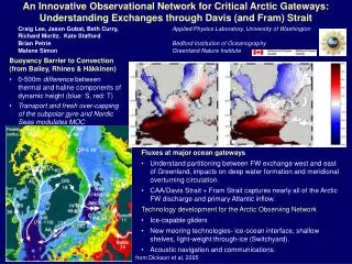
An Innovative Observational Network for Critical Arctic Gateways: Understanding Exchanges through Davis (and Fram) Strait Craig Lee, Jason Gobat, Beth Curry, Applied Physics Laboratory, University of WashingtonRichard Moritz, Kate Stafford Brian Petrie Bedford Institution of Oceanography Malene Simon Greenland Nature Institute Buoyancy Barrier to Convection (from Bailey, Rhines & Häkkinen) • 0-500m difference between thermal and haline components of dynamic height (blue: S, red: T) • Transport and fresh over-capping of the subpolar gyre and Nordic Seas modulates MOC • Fluxes at major ocean gateways • Understand partitioning between FW exchange west and east of Greenland, impacts on deep water formation and meridional overturning circulation. • CAA/Davis Strait + Fram Strait captures nearly all of the Arctic FW discharge and primary Atlantic inflow. • Technology development for the Arctic Observing Network • Ice-capable gliders • New mooring technologies- ice-ocean interface, shallow shelves, light-weight through-ice (Switchyard). • Acoustic navigation and communications. from Dickson et al, 2005
Mooring-based transport est. much smaller than previous. • Autumn hydro- deep waters warmer, more saline than climatology. • First successful under-ice excursion (glider and navigation system functioning properly). • ICECAT technology mature, consistent success near ice-ocean interface over shelves. Project Status and Progress
Collaboration with modeling efforts- BIO (Tang et al.), DAMOCLES (Karcher et al.) and Danish Meteorological Institute (Ribergaard & Kliem). Model evaluation and intercomparison, interpretation of observations. • Greenland Nature Institute- marine mammal studies (Simon), potential coordination of measurement programs and analysis efforts (Rysgaard). Training GINR personnel for glider operations. • Analysis incorporating narwhal-based measurements in Baffin Bay (Laidre). • ‘CATS’ efforts (including Falkner, Melling, Munchow, Straneo, Prinsenberg) to provide comprehensive view of CAA exchange. • DAMOCLES- Fram Strait collaboration- glider technology and science. Integration with Davis Strait analysis. Training AWI personnel. • Norwegian Meteorological Institute (Mautitzen). Norwegian Coastal Current at Station M. Training Norwegian Meteorological Institute personnel. • Transfer of mature ICECAT technology to Bering Strait investigations (Aagard, Woodgate). • Coordination of international efforts toward acoustic navigation and communications (ANCHOR workshop). Aiming for interoperable standards. Coordination and Integration
Multi-year water mass property and flux (volume, heat and freshwater) estimates to assess change. • Continue collaboration with modeling efforts (BIO, DMI, AWI, others?). Incorporate model results in our analysis. • Refine array configuration. Improved horizontal resolution over Greenland slope, reduced over Baffin shelf. Enhanced vertical resolution. • Improve public-access data distribution- CADIS and local site.http://iop.apl.washington.edu/seaglider • Continue glider-based sampling with AWI (Fram Strait) and Norwegian Meteorological Institute (Station M). Outflows and inflows. • Training other institutions for independent glider operations and working to prepare for ‘next step’ Arctic glider deployments. • Many improvements to glider technology- extended endurance, reliability, new CPU architecture, acoustics, sensors. Leveraged from other programs. • Develop acoustic communications and ‘data depot’ to reduce risk for extended under-ice missions, looking toward future Arctic applications. • Extend ICECAT for light-weight, long-endurance through-ice moorings, near-surface ‘reach’ for conventional subsurface moorings? Future Directions and 2008 Planning
S • Challenges • Small internal deformation scale- dynamically wide strait. • Broad West Greenland shelf. • Ice cover & icebergs. • Freshwater moves in thin (~50 m) surface layer. • Quantify liquid & ice contributions at monthly to inter-annual time scales. Moorings:Ice draft/velocity, absolute geostrophic velocity, low-mode u, T, S structure, marine mammals (‘06-’08) Shelf Moorings: Low-cost (~$10k) ICECAT for T-S near ice-ocean interface, upward looking acoustic current profilers and bottom-mounted T-S. Acoustically-navigated Gliders: Repeated sections (5 km, resolves deformation scale) at O(week) timescales between 500-m isobaths. Samples at ice-ocean interface. Temperature, salinity, dissolved oxygen (other?). Ship-based Hydrographic Sections:Autumn. Biogeochemical tracers (nutrients, trace metals, TOC, TAlk, CFCs, oxygen isotopes. Spans broad region from S. Baffin Bay to N. Labrador Sea.
Seaglider and Sensors • Hull length: 1.8 m, Wing span: 1.0 m • Mass: 52 kg • Surface to 1000 m. • Slow: horizontal speed 0.1 - 0.45 m/s (~22 km or 12 nm per day @0.25 m/s) • Vertical speed 0.06 m/s (minimum) • Endurance depends on ambient stratification, dive depth and desired speed • Longest range to date: 3900 km • Longest endurance to date: 31 weeks • Sensors: SBE conductivity & tempreature, SBE43 or Aanderaa optode dissolved oxygen. Fluorometers, backscatter, ADCP may be possible. Operations beneath ice require acoustic navigation (RAFOS), advanced autonomy. Acoustic data upload desirable for ‘insurance’. First section beneath ice-covered western Davis Strait in Dec 2006… the system works, but there have also been setbacks associated with platform reliability. IPY/AON developments include refining under-ice glider system, implementing moored ‘data depot’ for periodic data offload while operating under ice. • ICECAT for shallow shelves, moorings • Samples in ice-threatened near-surface layer. • Shallow element expendable, data logged below. • Inexpensive (~$10k), deploy many. • 2004(1), 2005(2), 2006(4)… • Contributing this technology to Bering Strait, other projects.
Autumn 2004 – Autumn 2010 • One cruise (mooring/glider service, hydrographic surveys) each autumn. • Data dissemination:- Project web site.- As specified by AON and ARCSS data managers.- DAMOCLES WP6. • Working on near real-time distribution for glider data… not yet there. • Science and engineering collaborations with:Canadian IPY (Melling, Carmack projects)DAMOCLES (AWI, Fram Strait)Norwegian IPY (NMI, NPI, Station M line)Nares Strait/Baffin and Hudson Strait (proposed) • Platform development for Switchyard.