Remote Sensing Platforms
Remote Sensing Platforms. Remote Sensing Platforms - Introduction. Allow observer and/or sensor to be above the target/phenomena of interest Two primary categories Aircraft Spacecraft

Remote Sensing Platforms
E N D
Presentation Transcript
Remote Sensing Platforms - Introduction • Allow observer and/or sensor to be above the target/phenomena of interest • Two primary categories • Aircraft • Spacecraft • Each type offers different characteristics, advantages & disadvantages in terms of range, cost, stability, frequency, and scale
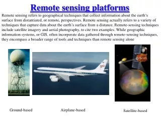
Types of Platforms • Stationary • Hand-held / cranes • Captive/tethered balloons • Manned and unmanned • Useful for acquiring low altitude imagery with frequent coverage for dynamic phenomena • Relatively inexpensive, stable
Types of Platforms • Lighter-than-air • Free floating balloons • Restricted by atmospheric conditions • Used to acquire meteorological/atmospheric data • Blimps/dirigibles • Major role - news media/advertisers • Helicopters • Can pin-point locations • Lack stability and vibrate
Low Altitude Aircraft • Generally operate below 30,000 ft • Most widely used are single engine or light twin engine • Imagery can be obtained by shooting out the window or placing camera mount on window or base of aircraft • Suitable for obtaining image data for small areas (large scale)
High Altitude Aircraft • Operate above 30,000 ft • Includes jet aircraft with good rate of climb, maximum speed, and high operating ceiling • Stable • Acquire imagery for large areas (smaller scale)
U-2/ER-2 • Lockheed U-2 high altitude reconnaissance aircraft. Many U-2s are still in service as earth resource observation aircraft. 70,000 feet (21,000 m) Jensen, 2000
Advantages/Disadvantages of Aircraft • Advantages • Acquire imagery under suitable weather conditions • Control platform variables such as altitude • Time of coverage can be controlled -- flexibility • Easy to mobilize • Disadvantages • Expensive – primarily cost of aircraft • Less stable than spacecraft • Drift off course • Random attitude changes (turbulent motions) • Motion blurring
Spacecraft • Numerous programs • Manned and unmanned systems
Range • Range for spacecraft is determined by orbit, which is fixed in altitude and inclination http://www.youtube.com/watch?v=E4k3kEA3pmo • Sun synchronous– near polar; cross equator at approximately same local time each day • Geostationary – fixed orbit over equator; primarily meteorological systems More Information: http://earthobservatory.nasa.gov/Features/OrbitsCatalog/page2.php
Aerial Support Hardware • Used to improve quality of imagery by • Reducing effect of platform motion • Keeping attitude constant • Image motion compensator • Moves film in same direction as aircraft at speed proportional to aircraft velocity • Gyro Stabilization • Stabilizes camera within plane to keep it pointing • Adjusts orientation of camera if attitude of plane shifts
Aerial Cameras - Digital • During exposure lens focuses light on bank of detectors • Exposure causes an electrical charge that is related to amount of incident energy • Electrical signal (analog) is converted to a digital brightness value • Uses area array of solid-state charge-coupled-device (CCD) detectors in place of film
Aerial Cameras – Digital (cont) • Single chip camera • Uses single full-frame CCD • Filter is placed over each pixel to capture red/green/blue or NIR/red/green wavelengths • Three or Four camera system • Use 3 or 4 separate full-frame camera/CCDs • Each sensitive to different wavelength
Hue Natural Color Color Theory • Primary colors • Red • Blue • Green • Color characteristics • Hue – dominant l (color) • Saturation – purity of color • Intensity (value) – light/dark Saturation Intensity
http://missionscience.nasa.gov/ems/emsVideo_04infraredwaves.htmlhttp://missionscience.nasa.gov/ems/emsVideo_04infraredwaves.html
Landsat http://www.youtube.com/watch?v=BPbHDKgBBxA
Landsat – Satellite • Weight ~ 2200 kg (5000 lbs) • Length ~ 4.5 m (14 ft) • Width ~ 3 m (9 ft)
Landsat – Orbit • Sun synchronous, near polar • ~ 705 km altitude • 9:42 am equator crossing
Landsat Worldwide Reference System • Location over earth catalogued by WRS path/row • Each scene covers 185 km (wide) by 170 km (long)
70’s 80’s 90’s
Deforestation in Bolivia from 1975 to 2000 Source: http://www.satimagingcorp.com/gallery/landsat-deforestation-bolivia.html
Landsat - Thematic Mapper (TM) • Introduced on Landsat 4 (1982) • Improvement over MSS on Landsat 1-3 • Spectral – extended spectral region – visible, NIR, mid-IR and thermal • Spatial – 30m vs. 80m (120m for thermal) • Radiometric – 8-bit vs. 6-bit • Temporal – 16 day (Landsat 1-3, 18 day) • *note* MSS continued on Landsat 4 & 5
SPOT Satellite System • Satellite Pour l’Observation de la Terre (SPOT) • French Space Agency & other European countries
SPOT – Launch Vehicle • Ariane rocket – European design & manufacture • Launch site – French Guiana
Landsat-TM SPOT-XS
SPOT HRV Design & Operation • HRV (High Resolution Visible) • Linear array ‘pushbroom’ system • Mirror focuses reflected energy on bank of detectors arranged side-by-side and perpendicular to satellite orbit track • A line of data is obtained by sampling detectors along the array 1st dimension 2nd dimension
SPOT Sensors • SPOT 1 – 3 • two HRV sensors • SPOT 4 & 5 • two HRV sensors • Vegetation sensor • HRV sensor (High Resolution Visible) • panchromatic • multi-spectral • VEGETATION sensor • multi-spectral
SPOT HRV - Panchromatic • Panchromatic (PAN) • Spatial resolution: 10 m • Spectral resolution: 0.51 – 0.73 mm
SPOT HRV – Multispectral • Multispectral (XS) • Spatial resolution: 20 m • Spectral resolution • 0.50-0.59 mm • 0.61-0.68 mm • 0.79-0.89 mm • 1.58-1.75 mm (SWIR band added to SPOT 4)
SPOT - Pointability • Increased imaging frequency
SPOT – Pointability (cont) • Stereoscopic imaging Day 1 Day 2
NASA EOS – Earth Observing System • Integrated experiment to study earth as a system • Planned as imaging and non-imaging instruments on series of satellites to study different science objectives • EOS AM-1, renamed Terra launched in 1999 • EOS PM-1, renamed Aqua launched in 2002 • Sensors include MODIS, ASTER, MISR, CERES, MOPITT
Remote Sensing Data available in San Diego 2007 Wildfires • Areal Photos (NEOS – a light weighted aircraft), • UAV (NASA’s Ikhana unmanned aircraft ) • MODIS (NASA) • FORMOSAT-2 (Taiwan’s NSPO) • EO-1 (NASA) • IKONOS (commercial) • SPOT (commercial) • QuickBird (commercial) • GOES-W (NASA)
NASA Unmanned Aerial Vehicles (UAVs) -- Ikhana http://www.nasa.gov/centers/dryden/news/Features/2007/wildfire_socal_10_07.html
MODIS (Terra and Aqua) 250m, 500m (daily) EO-1 (30m) – 16 days (not daily) NASA GOES-W (b/w, very low resolution) Ikhana (UAV) (small coverage)
FORMOSAT-2 Imagery (high resolution, daily, large coverage, nature-color composites) November 8-19, 2007, FORMOSAT-2