Download
1 / 1
10 likes | 149 Vues
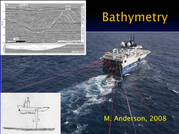
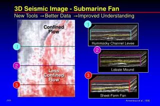
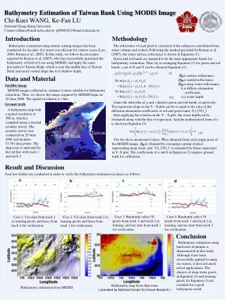
Bathymetry Estimation of Taiwan Bank Using MODIS Image Chi- Kuei WANG, Ke -Fan LU National Cheng Kung University Contact: chikuei@mail.ncku.edu.tw ; p66981021@mail.ncku.edu.tw. Introduction. Methodology.

E N D
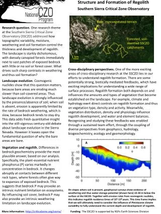
Bathymetry Estimation of Taiwan BankUsing MODIS Image • Chi-Kuei WANG, Ke-Fan LU • National Cheng Kung University • Contact:chikuei@mail.ncku.edu.tw; p66981021@mail.ncku.edu.tw Introduction Methodology Bathymetry estimation using remote sensing images has been conducted for decades. It is most cost efficient for remote ocean (Leu, 2004; Roman et al., 2007). In this study, we follow the procedure reported by Roman et al. (2007), who has successfully generated the bathymetry of Golf of Lion using MODIS, and apply the same procedure to Taiwan Bank, which is near the middle line of Taiwan Strait and rarely visited ships due to it shallow depth. The reflectance of each pixel is consisted of the radiances contributed from water column and seabed. Following the method provided by Roman et al. (2007), the water surface reflectance is shown in Equation (1). • Green and red bands are reported to be the most appropriate bands for bathytmetry estimation. Thus, by re-arranging Equation (1) for green and red bands, a set of X and Y can be obtained Equation (2) : is surface reflectance; is seabed reflectance; is deep-water reflectance; k is diffuse attenuation coefficient; z is water depth. Data and Material Satellite image • MODIS images collected in summer is more suitable for bathymetry estimation. Thus, we choose the image acquired by MODIS/Aqua on 26 June 2006. The spatial resolution is 1 km . (2) where the subscribe of g and r denotes green and red bands, respectively. The regression slope in the Y - X plot can be is equal to the ratio of the diffusion attenuation coefficients of red and green band, . Ground truth A bathymetry map with a spatial resolution of 500 m, which is compiled using a decadal acoustic survey. The acoustic survey was conducted on 29 June 2006 and includes 53,781 data points. The ship route is indicated by the red line with track 1 and track 2. After applying the rotation on the Y – X plot, the water depth can be estimated along with the line of regression. And the mathematical form of z is shown in Equation (3). track 2 track 1 Taiwan (3) Taiwan Bank For the above mentioned values, is obtained from each single pixel of the MODIS image, is obtained by averaging a group of pixel representing deep water, and is estimated by linear regression in Y- X plot. The coefficients of a and b in Equation (3) requires ground truth for calibration. Result and Discussion • Four test studies are conducted in order to verify the bathymetry estimation accuracy as follows. • Case 3: Randomly select 30 pixels from track 1 and track 2 as training, and use data from track 1 for verification. • Case 4: Randomly select 30 pixels from track 1 and track 2 as training, and use data from track 2 for verification. Case 1: Use data from track 1 as training pixels and those from track 2 for verification. • Case 2: Use data from track 2 as training pixels and those from track 1 for verification. Conclusion Bathymetry estimation using band ratio technique is demonstrated in this study. Although it has been successfully applied to many sea waters, it does not merit trivial applications. The choices of deep water pixels in Equation (2) and training pixels for Equation (3) are essential for a good bathymetry result. Bathymetry map from ship sonar ( provided by National Center for Ocean Research ) Bathymetry estimation from MODIS