Download
1 / 28
280 likes | 288 Vues
This research synthesis explores the challenges and strategies for fostering representational competence in geoscience education, focusing on knowledge integration, use of representations, and making inferences about Earth processes from representations.

E N D
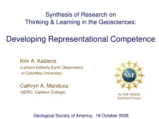
Synthesis of Research on Thinking & Learning in the Geosciences:Developing Representational Competence Kim A. Kastens (Lamont-Doherty Earth Observatory of Columbia University) Cathryn A. Manduca (SERC, Carleton College) An NSF REESE Synthesis Project Geological Society of America, 19 October 2009
Knowledge Integration in Geosciences:How to pull it all together? So many data types So many terms So many localities, all different So many modes of inquiry No consensus curriculum
Students struggle with knowledge integration Source: Baker & Piburn (1997) Constructing Science
How can Geoscience educators foster knowledge integration? • Integrate the content • Integrate around a place or region • Integrate around a societally-important problem • Integrate around big ideas of science • Integrate around professional practices of scientists • Practices of scientific discourse (IQWST) • Use of representations/ visualizations • Use of physical and computer models “Representational Competence” (Schank and Kozma, 2002)
Big Problem for Geoscience Education: • The Earth is 18 orders of magnitude larger than your classroom. Classroom (exaggerated) Earth
1. Bring small pieces of the Earth into your classroom (e.g. minerals, fossils) 2. Bring students out of the classroom to observe pieces of the Earth in nature. http://eesc.columbia.edu/courses/v1010/index.html http://www.school-assemblies-dinosaur-program.com/arts_in_education.htm There are three, and only three, ways to cope with this fundamental challenge: 3. Use representations
Geoscientists use a lot of kinds of representations • What does it mean to have “representational competence”? • How can we foster this expertise?
Four components of representational competence Ability to read and write geoscientists’ conventional representations (basic literacy) Metarepresentational understanding (the nature of representations and representational strategies) Ability to invent suitable representations to record and convey novel concepts or new data types Ability to make inferences about Earth processes from representations (“meaning-making”)
http://middlezonemusings.com/trust-chicken-egg/. 1. Ability to read and write geoscientists’ conventional representations (basic literacy) Concept of earthquake slip direction
2. Understanding about the nature of representations and representational strategies Learner (Earth) Adapted from Liben in Damon & Lerner, 2006.
Knowledge of representational strategies: Distinguish between… Reynolds et al. (2010) Reynolds et al. (2010) Data-driven Visualization Concept-driven Visualization Insight from Clark & Wiebe (2000) Journal of Technology Studies, v26.
Universal Truths Continent-ocean boundary is only sometimes an active margin (subduction zone). Mid-ocean ridge vulcanism is basaltic Conditional Truths Arc vulcanism is only sometimes andesitic Volcanoes occur above subduction zone Overriding plate is only sometimes continental Mantle wells up beneath mid- ocean ridge The Blue Planet p. 152 Concept-driven visualizations often overspecify; they commit to a single set of options.
Expert’s epistemological model of one data-driven visualization Collaborator: Sandra Swenson
Knowledge of representational strategies: Distinguish between… Representation suitable for data interpretation Representation suitable for communicating www.ferdinand-engelbeen.be/klimaat/eemian.html Insight from Dutrow (2007) www.geography.wisc.edu/classes/geog331/VostokSlide400kweb.jpg
3. Ability to invent suitable representations to record and convey novel concepts or new data types Cross-section William Smith Portions of the first geological map and legend http://www.unh.edu/esci/greatmap.html http://en.wikipedia.org/wiki/File:William_Smith_(geologist).jpg
Novices Invent Representational Strategies Source: Enyedy (2005).
Novices Invent Representational Strategies Invented representations for dip angle Collaborators: Lynn Liben, Shruti Agrawal, Toru Ishikawa
Eventually, the professionally accepted representations are introduced… …and come across as an ingenious solution to an authentic representational challenge …. …. rather than an arbitrary, imposed convention.
Divergent Plate Boundary Transform Plate Boundary Continental Fragment Seamounts Divergent Plate Boundary 4. Ability to make inferences about Earth processes from representations Kastens, K.A., Macdonald, K.C., Becker, K., and Crane, K., 1979, Marine Geophysical Researches, 4, 129-151.
Suggestion for meaning-making: Hypothesis templates There are recurring patterns in representations. Example: in a spatial representation, objects or phenomena are clustered.
One final thought:In Geoscience education, representational competence is a means, not an end. Learner (Earth) Earth Science learning goals are here . . . . . . not here Adapted from Liben in Damon & Lerner, 2006.
Students no longer need representational strategy of topographic contours to examine landforms! Learning goal: How glaciers shape the landscape Google Maps DeBruin, Richard (1970) 100 Topographic Maps: Illustrating Physiographic Features, p19.
Summary • Because of the size and spatial character of Earth phenomena, geoscientists use many and varied representations • Competence in using representations is a core expertise in Geoscience which can serve as a unifying theme across the curriculum • Competencies include: • Ability to understand and produce standard Geo representations • Metarepresentational understanding about how representations work in general • Ability to invent effective representations to convey novel ideas or observations • Ability to infer meaning about Earth processes from representations • Representational competence in Geosciences is a means not an end; the goal is to understand the referent, the Earth.