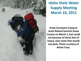
CBRFC March 2011 Water Supply Webinar
470 likes | 624 Vues
CBRFC March 2011 Water Supply Webinar. 1pm, March 7, 2011 Kevin Werner. These slides: www.cbrfc.noaa.gov/present/present.php. Outline. February Weather Review Snow States Water Supply Forecasts. Web Reference: www.cbrfc.noaa.gov/wsup/pub2/map/html/cbrfc .1.2011. html .

CBRFC March 2011 Water Supply Webinar
E N D
Presentation Transcript
CBRFCMarch 2011Water Supply Webinar 1pm, March 7, 2011 Kevin Werner These slides: www.cbrfc.noaa.gov/present/present.php
Outline • February Weather Review • Snow States • Water Supply Forecasts Web Reference: www.cbrfc.noaa.gov/wsup/pub2/map/html/cbrfc.1.2011.html
Snow February 7 (above) March 7 (right) Web Reference: http://www.cbrfc.noaa.gov/gmap/gmapm.php?scon=checked
Snow: Upper Green Basin (above Flaming Gorge) Web Reference: http://www.cbrfc.noaa.gov/station/sweplot/sweplot.cgi???open
Snow:Colorado Mainstem (above Cameo) Web Reference: http://www.cbrfc.noaa.gov/station/sweplot/sweplot.cgi???open
Snow:Gunnison Basin Web Reference: http://www.cbrfc.noaa.gov/station/sweplot/sweplot.cgi???open
Snow:San Juan Basin Web Reference: http://www.cbrfc.noaa.gov/station/sweplot/sweplot.cgi???open
Snow:Lower Colorado Web Reference: http://www.cbrfc.noaa.gov/station/sweplot/sweplot.cgi???open
Snow:Six Creeks in Salt Lake County Web Reference: http://www.cbrfc.noaa.gov/station/sweplot/sweplot.cgi???open
Snow Maps Web Reference: http://www.nohrsc.nws.gov
Last 7 days… Web Reference: http://water.weather.gov
Forecast Precipitation • Active weather period continues!! • Storm #1 passing through today/tomorrow • Storm #2 Friday/Saturday (mostly north) • Storm #3 Sunday/Monday • Total accumulations around 2” of water in northern basins Web Reference: www.hpc.noaa.gov
La Nina Update Web Reference: http://www.cpc.noaa.gov and iri.columbia.edu/climate/ENSO
Web Reference: http://www.cbrfc.noaa.gov/climate/climoForecasts.cgi
March 1, 2011 • Water Supply Forecasts • Highlights: • Wet winter continues for much of the basin with many forecasts higher than any year since 1997 • Some northern basins predicting flows near the top 10% • Forecasts slightly higher across northern basins since Feb 1 • San Juan and lower basin somewhat lower since Feb 1 Web Reference: www.cbrfc.noaa.gov/gmap/gmapm.php?wcon=checked
Web Reference: www.cbrfc.noaa.gov/gmap/gmapm.php?wcon=checked
Web Reference: www.cbrfc.noaa.gov/gmap/gmapm.php?wcon=checked
Web Reference: www.cbrfc.noaa.gov/gmap/gmapm.php?wcon=checked
Web Reference: www.cbrfc.noaa.gov/gmap/gmapm.php?wcon=checked
Web Reference: www.cbrfc.noaa.gov/gmap/gmapm.php?wcon=checked
Lake Powell Forecast • Equalization determined (in part) on April 1 forecast: • For 2011, April 1 median forecast would need to be about 7.0 maf or lower to avoid equalizing releases from Lake Powell • March 1 median forecast is 9.2 maf • Forecast would need to drop 2.2 maf or more • Historical forecasts dropping 1.5 maf or more in last 30 years: • 2004: 6.5 to 4.0 (-2.5) • 1999: 6.5 to 4.8 (-1.7) • 2007: 5.6 to 4.0 (-1.6) • 1997: 12.5 to 11.0 (-1.5) • Therefore forecast probability of April 1 forecast dropping below 7.0 mafis 1/30 or about 3% • However….
Web Reference: www.cbrfc.noaa.gov/gmap/gmapm.php?wcon=checked
Web Reference: www.cbrfc.noaa.gov/gmap/gmapm.php?wcon=checked
Web Reference: www.cbrfc.noaa.gov/gmap/gmapm.php?wcon=checked
Online Publication Web Reference: www.cbrfc.noaa.gov/wsup/pub2/map/html/cpub.php
Web Reference: www.cbrfc.noaa.gov/wsup/pub2/map/html/cpub.php
Peak Flow Forecast • March 1 Peak flow forecasts highlights:
CBRFC News • Basin Focal Points (Available to discuss forecasts: 801.524.5130) • Upper Colorado: Brenda Alcorn • Green: Ashley Nielson • San Juan / Gunnison: Tracy Cox • Great Basin: Brent Bernard • Lower Colorado (below Lake Powell): Greg Smith • Here now: • Sign up for all webinars through May 2011 • Weekly ESP model guidance • Email product updates via govdelivery (can add more products / webpages upon request) • Changes to CBRFC webpage • Blog (blog.citizen.apps.gov/cbrfc) • Coming soon: • New water supply publication – example
Objectives • easily navigable to content • pages focused on water supply areas (powell, great basin, etc.) • high level “scoreboard” gives overview – can drill elsewhere for details • updating throughout season Mockups for WS “pub” Pages
tabs for various info types Basin Overview Basin Forecasts Weather & Climate Snow & Precip Soil Moisture Analysis Tools Forecast Point: Flaming Gorge (Only Major basin outlets) Official Coordinated Seasonal Water Supply Forecast (Help?) Issued: February 1, 2011 Forecast period: Apr-Jul [click here to expand] Latest ESP Guidance Forecast: Issued: February 10, 2011 Forecast period: Apr-Jul [click here to expand] Snowpack: Current Basin Average Snowpack (as of 2/1): Precipitation: Current Basin Average Precipitation (as of Feb 10, 2011): Soil Moisture: Nov 1 basin average soil moisture: Forecast points within basin: Mockup WS “pub” Pages • Better Map showing: • Major sub-basins (TBD) • NOT color coded by forecast • Individual forecast points available through point selection 370 kaf 10% Exceedence 280 kaf 50% Exceedence 150 kaf 90% Exceedence 370 kaf 10% Exceedence 280 kaf 50% Exceedence 150 kaf 90% Exceedence 34” SWE 120% Of daily average 89% Of average peak 34” SWE 120% Of daily average 89% Of average peak various search options
tabs for various info types Basin Overview Basin Forecasts Weather & Climate Snow & Precip Soil Moisture Analysis Tools Official Coordinated Seasonal Water Supply Forecast (Help?) Forecast Point: Flaming Gorge (Only Major points Issued: February 1, 2011 Forecast period: Apr-Jul Latest ESP Guidance Forecast: Issued: February 10, 2011 Forecast period: Apr-Jul Mockup WS “pub” Pages 370 kaf 10% Exceedence 370 kaf 10% Exceedence 180 % Of historical median 180 % Of historical median 160 % Of historical mean 160 % Of historical mean 1st of 80 Of historical flows 1st of 80 Of historical flows • Better Map showing: • Major sub-basins (TBD) • NOT color coded by forecast • Individual forecast points available through point selection -10% From previous month 140 % Of historical median 140 % Of historical median 110 % Of historical mean 110 % Of historical mean 280 kaf 50% Exceedence 280 kaf 50% Exceedence 10th of 80 Of historical flows 10th of 80 Of historical flows -1% From previous month 150 kaf 90% Exceedence 150 kaf 90% Exceedence 90 % Of historical median 90 % Of historical median 80 % Of historical mean 80 % Of historical mean 70th of 80 Of historical median 70th of 80 Of historical median +15% From previous month -10% From previous month Current Snowpack: xx% of average Current Precip: xx% of average Fall Soil Moisture: xx% of average Listing of all forecast points with current forecasts (clickable) -1% From previous month +15% From previous month various search options
tabs for various info types Basin Overview Basin Forecasts Weather & Climate Snow and Precip Soil Moisture Analysis Tools Mockup WS “pub” Pages Current official forecast: Change from previous month: Current ESP guidance (options: with QPF, with GFS, with CFS): Change from previous (week, month, year): Forecast discussion (e.g. ~2 paragraphs a la current publication) Distinguish forecaster “looked at” forecasts from those that are not various search options
tabs for various info types Basin Overview Basin Forecasts Weather & Climate Snow and Precip Soil Moisture Analysis Tools Mockup WS “pub” Pages Time series plots: Forecasts and climatology QPF (time options): XX in or % average Climate outlook (time options): % average various search options
tabs for various info types Basin Overview Basin Forecasts Weather & Climate Snow & Precip Soil Moisture Analysis Tools Mockup WS “pub” Pages Percent of average precip (area weight / runoff weight): Percent of average snow Percent snow required for average runoff Map with current observed conditions various search options
More Resources • www.cbrfc.noaa.gov • Wateroutlook.nwrfc.noaa.gov • Tentative April webinar: 1pm April 7 • April peak flow webinar: TBD (contact me if you’d like to participate)
Kevin Werner CBRFC Service Coordination Hydrologist Phone: 801.524.5130 Email: kevin.werner@noaa.gov Feedback, Questions, Concerns always welcome….