Antarctic Ice Velocity Mapping Project: MEaSUREs Initiative
This project aims to create new Earth Science Data Records by mapping Antarctic ice velocity using satellite data, contributing to improved understanding of ice dynamics and their impact on sea level change.

Antarctic Ice Velocity Mapping Project: MEaSUREs Initiative
E N D
Presentation Transcript
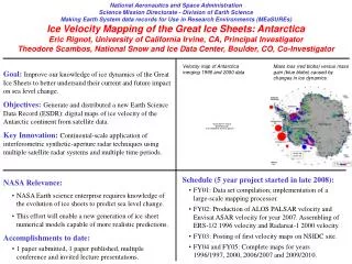
National Aeronautics and Space Administration Science Mission Directorate - Division of Earth Science Making Earth System data records for Use in Research Environments (MEaSUREs) Ice Velocity Mapping of the Great Ice Sheets: Antarctica Eric Rignot, University of California Irvine, CA, Principal Investigator Theodore Scambos, National Snow and Ice Data Center, Boulder, CO, Co-Investigator Velocity map of Antarctica merging 1996 and 2000 data Mass loss (red blobs) versus mass gain (blue blobs) caused by changes in ice dynamics. Goal: Improve our knowledge of ice dynamics of the Great Ice Sheets to better undersand their current and future impact on sea level change. Objectives: Generate and distributed a new Earth Science Data Record (ESDR): digital maps of ice velocity of the Antarctic continent from satellite data. Key Innovation: Continental-scale application of interferometric synthetic-aperture radar techniques using multiple satellite radar systems and multiple time periods. • Schedule (5 year project started in late 2008): • FY01: Data set compilation; implementation of a large-scale mapping processor. • FY02: Production of ALOS PALSAR velocity and Envisat ASAR velocity for year 2007. Assembling of ERS-1/2 1996 velocity and Radarsat-1 2000 velocity. • FY03: Posting of first velocity maps on NSIDC site. • FY04 and FY05: Complete maps for years 1996/1997, 2000, 2006/2007 and 2009/2010. • NASA Relevance: • NASA Earth science enterprise requires knowledge of the evolution of ice sheets to predict sea level change. • This effort will enable a new generation of ice sheet numerical models capable of more realistic predictions. • Accomplishments to date: • 1 paper submitted, 1 paper published, multiple conference and invited lecture presentations.
National Aeronautics and Space Administration Science Mission Directorate - Division of Earth Science Making Earth System data records for Use in Research Environments (MEaSUREs) Ice Velocity Mapping of the Great Ice Sheets: Antarctica Eric Rignot, University of California Irvine, CA, Principal Investigator Theodore Scambos, National Snow and Ice Data Center, Boulder, CO, Co-Investigator ALOS PALSAR: Pros: most pro-efficient InSAR data set for ice sheet mapping due to high temporal coherence, fine spatial resolution and long repeat cycles. Cons: Ionospheric disturbances are a limiting factor in the interior, distribution of data is complicated by the frame structure of the data (as opposed to full orbits), and the long repeat offers limited possibility to map grounding lines. Current status: Received 593 orbits from year 2007 and started the processing. Ordered half of 303 orbits for year 2008. Future data needs: Would like to order 550 full orbits per year for 2009-2011. Expected results: Most complete mapping of coastal velocities made to date and temporal changes for 2006-2011. Greatest challenges: Please make sure JAXA acquires the data and that ASF has the processing capability to order, process and distribute them to us in a timely fashion. Second order priority: fill in acquisition gaps not covered in previous years (2006 and 2007).
National Aeronautics and Space Administration Science Mission Directorate - Division of Earth Science Making Earth System data records for Use in Research Environments (MEaSUREs) Ice Velocity Mapping of the Great Ice Sheets: Antarctica Eric Rignot, University of California Irvine, CA, Principal Investigator Theodore Scambos, National Snow and Ice Data Center, Boulder, CO, Co-Investigator ENVISAT ASAR: Pros: most pro-efficient InSAR data set for interior ice sheet mapping: long orbits, wide swath, long repeat, coverage farther south than ALOS, HH pol. adopted by ESA maintains high coherence. Cons: Coherence is lower than at L-band, some areas systematically fail to correlate (Wilkes Land and West Antarctica), and the long repeat offers limited possibility to map grounding lines. Current status: Received 362 orbits from year 2007 from ESA thanks to Help Desk and Henri Laur, Mission Manager. ESA framed three complete mosaics for IPY: 2007, 2008 and 2009. Ordered 362 orbits for 2008. Future data needs: Would like to maintain 362 orbits per year for 2009-2011. Expected results: Most complete interior mapping of velocities. Greatest challenges: Please make sure ESA acquires the data and continues distributing them to us as efficiently and generously as they did with the 2007 data.
National Aeronautics and Space Administration Science Mission Directorate - Division of Earth Science Making Earth System data records for Use in Research Environments (MEaSUREs) Ice Velocity Mapping of the Great Ice Sheets: Antarctica Eric Rignot, University of California Irvine, CA, Principal Investigator Theodore Scambos, National Snow and Ice Data Center, Boulder, CO, Co-Investigator OTHER ISSUES: We absolutely need the help of our Canadian partners to get Radarsat-2 coverage of the regions south of 81 degree south. These were only partially covered in 1997 by Radarsat-1. We need a complete coverage. No other sensor can do it. Includes key glaciers e.g. Byrd Glacier. Future sensors (Sentinel-1, ALOS PALSAR-2, DesdynI) should consider shorter revisit cycles in order to map grounding line positions (requires three consecutive passes at short (a few days up to one week) revisit. Grounding line positions are essential to know for ice sheet numerical modeling, monitoring of ice sheet evolution and for acccurate calculation of ice sheet losses. Currently, only ERS-1/2 has been able to map all grounding lines in Antarctica. Radarsat-1 and ALOS PALSAR only work on relatively slow moving glaciers.