Download
1 / 1
10 likes | 130 Vues
Geologic Setting of the Upper Nehalem Watershed Framework for Geomorphic Analysis and Habitat Assessment Cristina Francisco Earth & Physical Science Dept. Western Oregon University, Monmouth, Oregon email: cfrancisco10@wou.edu. ABSTRACT

E N D
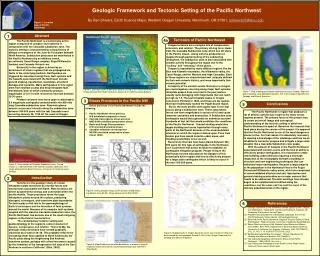
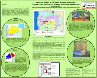
Geologic Setting of the Upper Nehalem Watershed Framework for Geomorphic Analysis and Habitat Assessment Cristina Francisco Earth & Physical Science Dept. Western Oregon University, Monmouth, Oregon email: cfrancisco10@wou.edu ABSTRACT The geologic setting of the Nehalem watershed is strongly influenced by the active tectonic associated with the Cascadia Subduction Zone and Oregon Coast Range. Bedrock stratigraphy includes several formations ranging in age from Eocene up to middle Miocene, in addition to Quaternary terrace gravel and alluvium. Topographic lineaments in the Nehalem basin are associated with known fold structures, faults, formation contacts and/or resistant strata. Surficial geology is characterized by parent rock and soils formed through volcanic and depositional processes. Tectonic Setting Location Figure 5 In the early Eocene, the subduction zone formed by the Farallon oceanic plate (the remnant fragment is now named Juan de Fuca Plate) was underthrusted beneath the North American plate (Eriksson A, 8). The Cascadia subduction zone is still active today (Fig. 5) with potential for large megathrust earthquakes and tsunamis. New research shows that in the last couple of thousand years, earthquakes have had a recurrence interval of one in 300 to 500 years (Goldfinger et al, 2008). Figure 3 Stratigraphy Figure 1 Tillamook Volcanics (Ttv) - subaerial basaltic flows and breccias, pillow lavas, lapilli tuffs with sedimentary interbeds (upper and middle Miocene) Keasey Formation(Tss) -Tuffaceous siltstone / sandstone (upper and middle Miocene) Scappoose Formation and Pittsburg Bluff Formation (Tmst) - Marine sedimentary and tuffaceous rocks (middle Miocene to upper Eocene) Marine sedimentary rocks undifferentiated (Tms) - fine to medium grained marine siltstone and sandstone with tuffaceous beds (middle and lower Miocene) Mafic and intermediate intrusive rocks (Tim) - dikes, plugs, and sills of basalt, diabase, gabbro, and lesser andesite (Miocene) Mafic intrusions (Ti) - sheets, sills, and dikes of massive ferrogabbro (Oligocene) Wanapum Basalt (Tcw) -Columbia River Basalt Group, flows of gray to dark-gray, medium-grained, porphyritic basalt (middle Miocene) Cowlitz Formation(Tco) - arkosic to basaltic marine sandstone, siltstone, and mudstone. Locally interbedded with Goble Volcanics (middle and upper Eocene ) Pittsburg Bluff Formation - fossiliferous sandstone and shale (middle Oligocene) Grande Ronde Basalt (Tcg) - flows of dark-gray to black tholeiitic basalt (middle and lower Miocene) Quaternary Landslide Deposits (Qls) - Holocene and Pleistocene deposits of colluvial diamicton Quaternary Alluvial Deposits (Qal) - late Pleistocene to Holocene, alluvial deposits of the Nehalem river and related tributaries Located in the northwest corner of Oregon, the Nehalem watershed is surrounded by rivers tributary to subjacent basins: Columbia, Scappoose, Tualatin and also tributary to the Pacific Ocean (Fig. 1). Topography Saddle Mt. Nehalem River Sugar Loaf Mt. Climate Figure 6 A Round Top Mt. The climate is moderated by proximity to the Pacific Ocean that induces a maritime climate with rainy winter months and dry summers. Average annual precipitation ranges between 80 and 150 inches (ODF, 2005) (Fig. 2). B C Topographic features are diverse, from steep slope mountains (Coast Range) to gentle slope hillslopes, terraces, and stream valleys (Fig. 6A). Also, the altitude increases from the sea level at Nehalem Bay to 3,283 feet at Saddle Mountain (Fig. 6B and 6C). Figure 2 Soils Nehalem soils are spatially correlated with geologic and climatic factors. The flood plains and terraces consist of deep well-drained soils that have formed in alluvium. Predominant soils include: Nehalem Series formed in more recent alluvium; Muren soils formed in colluvium derived from igneous rocks; and Hembre silt loam associated with rugged areas in the Coast Range (USDA). • Eriksson A, Stratigraphy, Structure and Natural Gas Potential of Tertiary Sedimentary and Volcanic Units, Clatskanie 7.5 Minute Quadrangle, Northwest Oregon, accessed on April 2012 at: http://ir.library.oregonstate.edu/xmlui/handle/1957/9061 • Newton, V., R Van Atta, Prospects For Natural Gas Production And Underground Storage Of Pipe-Line Gas In The Upper Nehalem River Basin Columbia-Clatsop Counties Oregon, State of Oregon, Dept. of Geology and Mineral Industries, 1976 • Oregon Department of Forestry: Upper Nehalem Analysis, 2005 • Goldfinger and others, 2008, Late Holocene Rupture of the Northern San Andreas Fault and Possible Stress Linkage to the Cascadia Subduction Zone: Bull. of the Seis. Soc. of Am., V. 98, pp. 861–889. • USDA Soil Conservation System – Soil survey of Clatsop, Columbia, Tillamook and Washington County • Walker G. W. and MacLeod N., Geologic Map of Oregon, US Geological Survey, 1991 Figure 1: Localization Map, Source GIS, author: C. Francisco Figure 2: Average Annual Precipitation in inches, Source: USDA NRCS Nehalem Figure 3: Geologic Map, Source GIS, author: C. Francisco Figure 4: Geologic units, Author Cristina Francisco Figure 5: Cascadia Subduction Zone Source: Robert J. Lillie - The Oregon Historical Society Figure 6A: Shaded Relief Map Nehalem Watershed Atlas Relief Model, source GIS Figure 6B: Nehalem River near Nehalem Bay, source: C. Francisco Figure 6C: Nehalem River near Vernonia , source C. Francisco Figure 4