Model Coupling
Objective Develop Sulis cyberinfrastructure components to enable rapid and effective coupling of numerical models used in coastal hazards research and prediction . Model Coupling

Model Coupling
E N D
Presentation Transcript
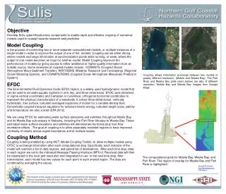
Objective Develop Suliscyberinfrastructure components to enable rapid and effective coupling of numerical models used in coastal hazards research and prediction. Model Coupling is the process of connecting two or more separate computational models, or multiple instances of a single model in order to improve the output of one of the models. Coupling can be either strong, where models exchange information at synchronization points while running, or weak, where the output of one model becomes an input for another model. Model Coupling improves the performance of models by giving access to either additional or higher quality information from an outside source. Some examples of coupled models include: COAWSTE (Coupled Ocean Atmosphere Wave Sediment Transfer), WRF/ROMS (Weather Research and Forecasting) (Regional Ocean Modeling System), and COAMPS/ROMS (Coupled Ocean Atmosphere Mesoscale Prediction System). Coupling allows information exchange between two models of greatly different resolution, (Mobile and Weeks Bay). The Fish River and Weeks Bay grids (seen below) are also of different resolution.Mobile Bay and Weeks Bay Images from Google Maps EFDC The Environmental Fluid Dynamics Code (EFDC Hydro) is a widely used hydrodynamic model that can be used to simulate aquatic systems in one, two, and three dimensions. EFDC uses stretched or sigma vertical coordinates and Cartesian or curvilinear, orthogonal horizontal coordinates to represent the physical characteristics of a waterbody. It solves three-dimensional, vertically hydrostatic, free surface, turbulent-averaged equations of motion for a variable-density fluid. Dynamically-coupled transport equations for turbulent kinetic energy, turbulent length scale, salinity and temperature are also solved (EPA 2012). We are using EFDC for estimating water surface elevations and salinities throughout Mobile Bay and its Weeks Bay sub-estuary in Alabama, including the Fish River tributary to Weeks Bay. These estimated water surface elevations and salinities will demonstrate hurricane plus river flow inundation effects . The goal of coupling is to allow separately modeled regions to have improved continuity of results across region boundaries and at multiple scales. Coupling Method Coupling is being enabled by using MCT (Model Coupling Toolkit), to allow multiple models using EFDC to exchange information after each computational step. Specifically, each instance of the model will maintain a list of data regions, and paired list of destinations. After each time step, data in each region are set to the indicated Message Passing Interface (MPI) id. Received data will then be resampled to the local grid resolution and integrated for use in the next time step. After transmission, each model has two values for each point in each shared region. The data are combined by averaging the values. The computational grids for Mobile Bay, Weeks Bay, and Fish River. The region of overlap for Weeks Bay and Fish River is highlighted. Donald W Johnson dwj12@msstate.edu CI Strategy 2