
Uploaded by
rufus
7 SLIDES
176 VUES
80LIKES
GeoTrack: Advanced Fire Crew Tracking System
DESCRIPTION
GeoTrack is an offline local geo-information system that utilizes cloud technology to provide tracking and information for fire crews. It includes GPS, mesh networking, and sensors to ensure accurate and reliable data collection. The system supports Truck A, Truck B, and mobile devices like iPad, running on an innovative WiFi-based app for seamless connectivity and real-time monitoring during firefighting operations.
Download
1 / 7
Télécharger la présentation 
GeoTrack: Advanced Fire Crew Tracking System
An Image/Link below is provided (as is) to download presentation
Download Policy: Content on the Website is provided to you AS IS for your information and personal use and may not be sold / licensed / shared on other websites without getting consent from its author.
Content is provided to you AS IS for your information and personal use only.
Download presentation by click this link.
While downloading, if for some reason you are not able to download a presentation, the publisher may have deleted the file from their server.
During download, if you can't get a presentation, the file might be deleted by the publisher.
E N D
Presentation Transcript
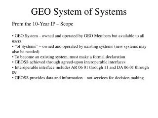
Local Geo Information System Offline “cloud” providing tracking and information for fire crews.
GPS / Mesh / Sensors GPS / Mesh / Sensors Truck A Truck B WiFi App App WiFi iPad


More Related