Download
1 / 2
20 likes | 116 Vues
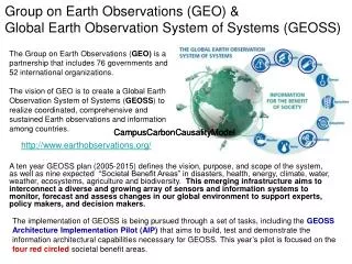
Explore the GEO System of Systems framework, fostering collaboration among existing and new observing and modeling centers to provide data and information across societal areas. The Group on Earth Observations System of Systems (GEOSS) offers interoperable interfaces for efficient data exchange and processing. This network enhances disaster management, health monitoring, energy, water resources, climate studies, weather forecasting, ecosystems preservation, biodiversity conservation, and agricultural practices.

E N D
GEO System of Systems • From the 10-Year IP – Scope • GEO System – owned and operated by GEO Members but available to all users • “of Systems” – owned and operated by existing systems (new systems may also be needed) • To become an existing system, must make a formal declaration • GEOSS achieved through agreed-upon interoperable interfaces • Interoperable interface includes AR 06 01 through 11 and DA 06 01 through 09 • GEOSS provides data and information – not services for decision making
Group on Earth bservations GEOSS components(existing if formally agreed, and new and required) Users in nine societal areas (disasters, health, energy, water, climate, weather, ecosystems, biodiversity, agriculture) Observation component Existing observing systems WWW/GOS (including EUCOS), GAW, WHYCOS, GTN-H, GCOS, GOOS, GTOS, COSMO-SkyMed New observing systems Ecosystems, etc. Access mechanism Data exchange and dissemination component Interoperable interfaces Interoperable interfaces Interoperable interfaces Data processing component Existing modeling centres GRDC, Global Mapping Project (Japan) ECMWF (GTS products) GPCC New modeling centres