Fire Risk Mapping for Southeast Asia Using AVHRR Imagery
Explore the Fire Risk Map for Southeast Asia, generated from AVHRR imagery. This map provides critical data for assessing fire hazards in the region, leveraging advanced satellite imagery and geographic information systems (GIS). Access is facilitated through various data stores including NASA, ESA, NGDC, and others. This collaborative effort aims to enhance the understanding and management of fire risks, making vital information available to researchers, policymakers, and environmental monitoring agencies. Utilize our platform for data search and integration.

Fire Risk Mapping for Southeast Asia Using AVHRR Imagery
E N D
Presentation Transcript
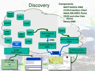
Components MAFF/NASDA WMS CCRS/CubeWerx Client NASA IDN GOFC Portal CEOS and other Data Stores Demis WMS Discovery NOAA NGDC ESA NASDA CCRS VMAP0 UMD GLCF MAFF MAFF/NASDA WMS MSU TRFIC JRC Demis (Netherlands) WMS UWM WMS DIF Metadata CCRS/CubeWerx WMS CCRS/CubeWerx Map Client Server GCMD GOFC Portal WMS Fire Risk Map for Southeast Asia from AVHRR Imagery click! click!
Data Search Components EDG Client : NASA Servers : Bureau of Meteorology (Aus) CCRS (Canada) HEOC/NASDA (Japan) DLR (Germany) ESA (Italy) USGS EDC (US) IRE (Russia) ISA (Israel) LARC (NASA-US) ORNL (NASA-US) GSFC (NASA-US) Others ... BOM Australia ESA Italy ORNL NASA DLR Germany CCRS Canada GSFC NASA LARC NASA V0 & CIP HEOC Japan JPL NASA USGS EDC IRE Russia ISA Israel EOSDIS Data Gateway Search Client EOSDIS Data Gateway click! click!
Components MAFF/NASDA WMS ESA/Ionic WFS ESA/Ionic WMS ESA/Ionic Map Client USGS EDC/ESRI WMS Demis WMS Data Feed NOAA NGDC ESA ATSR DMSP AVHRR Data Access & Interuse GISTDA ESA/Ionic WFS MAFF L7 Browse AIT VMAP0 WFS MAFF/NASDA WMS ESA/Ionic WMS USGS EDC/ESRI WMS Demis (Netherlands) WMS ESA/Ionic Map Client WMS WMS WMS Fire Risk Map for Southeast Asia from AVHRR Imagery click! click! click!
data Find, gather compress deliver
portal GRID Web
portal GRID Web data Find, gather compress deliver
Search, browse data Find, gather compress deliver