Global Forecast System (GFS) Model
Global Forecast System (GFS) Model. Previous called the Aviation (AVN) and Medium Range Forecast (MRF) models. Global model and 64 levels Relatively primitive microphysics. Sophisticated surface physics and radiation Run four times a day to 384 hr.

Global Forecast System (GFS) Model
E N D
Presentation Transcript
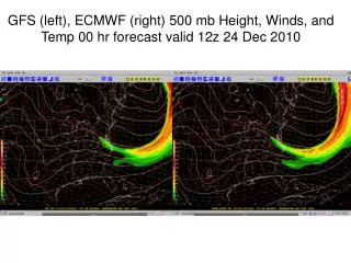
Global Forecast System (GFS) Model • Previous called the Aviation (AVN) and Medium Range Forecast (MRF) models. • Global model and 64 levels • Relatively primitive microphysics. • Sophisticated surface physics and radiation • Run four times a day to 384 hr. • Major increase in skill during past five years derived from using direct satellite radiance in the 3DVAR analysis scheme. • T382 (~35 km) over the first 180 hours (7.5 days) of the model forecast and T190 (70 km) for 180 through 384 hours--major implications for resolution change!
GFS • Just changed vertical coordinates from sigma to hybrid sigma/pressure… sigma at low levels to pressure aloft.
GFS Data Assimilation • Has a later data cut-off time than the mesoscale models…and thus can get a higher percentage of data. • Uses much more satellite assets..thus improve global analysis and forecasts. • Major gains in southern hemisphere • Based on 3DVAR
Skill Improvements (ECMWF) • Useful skill until: • - day 5 • 2000 - day 7 • 2003 - day 8
RUC • A major issue is how to assimilate and use the rapidly increasing array of offtime or continuous observations (not a 00 and 12 UTC world anymore! • Want very good analyses and very good short-term forecasts (1-3-6 hr) • The RUC ingests and assimilates data hourly, and then makes short-term forecasts • Uses the MAPS mesoscale model…which uses a hybrid sigma/isentropic vertical coordinate • Resolution: 13 km and 50 levels
13km RUC Terrain elevation - 100 m interval • Improvements expected from 13km RUC • Improved near-surface forecasts • Improved precipitation forecasts • Better cloud/icing depiction • Improved frontal/turbulence forecasts NCEP computer upgrade allows RUC13 to run in same time as current RUC20
Observations used in RUC Data Type ~Number Freq. -------------------------------------------------- Rawinsonde 80 /12h NOAA profilers 30 / 1h VAD winds 110-130 / 1h Aircraft (V,temp) 1400-4500 / 1h Surface/METAR 1500-1700 / 1h Buoy/ship 100-150 / 1h GOES precip water 1500-3000 / 1h GOES cloud winds 1000-2500 / 1h GOES cloud-top pres 10 km res / 1h SSM/I precip water 1000-4000 / 6h -------------------------------------------------- GPS precip water ~300 / 1h Mesonet ~5000 / 1h METAR-cloud-vis-wx ~1500 / 1h -------------------------------------------------- Cloud analysis variables NCEP RUC20 operational RUC13 (at NCEP June 2005)
RUC History – NCEP (NMC) implementations • - First operational implementation of RUC • - 60km resolution, 3-h cycle • 1998 – 40km resolution, 1-h cycle, • - cloud physics, land-sfc model • 2002 – 20km resolution • - addition of GOES cloud data in assimilation • 2003 – Change to 3dVAR analysis from previous OI • (April) • 2004 – Vertical advection, land use (April) • PBL-depth for surface assimilation (September) • 2005 – 13km resolution, new obs, new model physics • (June) • 2007 – WRF-based Rapid Refresh w/ GSI to replace RUC
20km RUC 13km RUC Soil moisture – 22z - 21 Feb 2005 Dark blue = water More detailed coastline with 13km resolution
WRF RUC • A new version of RUC has been developed, but not yet operational that uses the WRF model instead of the MAPS model.