Download
1 / 44
440 likes | 490 Vues
Explore the organization and impact of thunderstorms, identify severe conditions, and learn about different thunderstorm types and their environmental requirements. Understand global climate change effects on thunderstorm frequency and intensity.

E N D
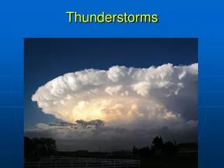
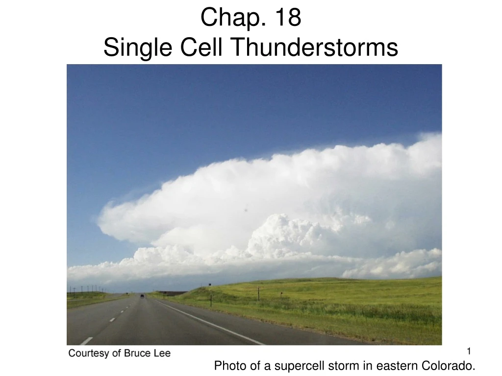
Chap. 18Single Cell Thunderstorms Photo of a supercell storm in eastern Colorado.
Learning objectives • Name the different ways thunderstorms organize • State the NWS criteria for a severe thunderstorm • Be able to list and describe the impacts of severe thunderstorms • Identify the environmental conditions conducive to severe and non-severe thunderstorm formation • Explain why vertical wind shear is necessary for severe or organized thunderstorms • Identify the structural characteristics of mesoscale convective systems (MCSs), squall lines, and supercell thunderstorms. • Identify the types of severe conditions most commonly associated with MCS, squall lines, and supercell thunderstorms • Identify the type of severe thunderstorm organization using radar and satellite imagery • Summarize the current understanding of how thunderstorm frequency and intensity will be affected by global climate change
Fig. 18.1. Locations of severe weather events during 2009: tornadoes (top), hail (middle), and damaging winds (bottom). Severe weather summaries are available from http://www.spc.noaa.gov
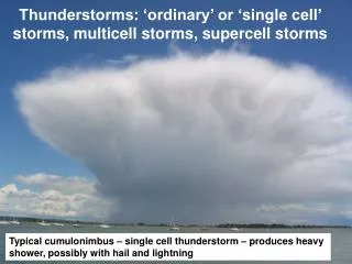
Thunderstorms • A cumulonimbus cloud that produces lightning (and hence thunder) • Very common (globally) • Transport heat and moisture vertically in the atmosphere • Most are not severe • Severe thunderstorm: • Hail > 1 inch diameter (¾ inch prior) • Wind gust >50 kt (58 mph) • Tornado • Ingredients for thunderstorm initiation: • Water vapor • Conditional instability • Lifting mechanism • For a severe thunderstorm, a 4th ingredient is: • d) Strong vertical wind shear
Thunderstorm Facts & Climatology • At any given time there are 2000 thunderstorms in progress • About 45,000 thunderstorms take place each day • Annually, The U.S. experiences about 100,000 thunderstorms. • About 16 million thunderstorms occur annually around the world! • The lightning from these storms strikes Earth about 100 times each second
Lifting from convergence zones(also termed convergent boundary zones, or CBZ) • Boundaries (narrow zone of contrast in temperature and/or humidity, and wind) • Gust front (generated from thunderstorm outflows) • Sea breeze • Cold front • Dry line • Gravity waves • ABIDE: Atmospheric Boundary Identification and Delineation Experiment • UAH experiment to examine how CBZ’s produce convective initiation in the daytime, nighttime, and period-in-between boundary layer
More definitions • Boundary Layer (BL) – the lowest 1-2 km of the atmosphere this is affected by the surface (heating, roughness, etc); the BL is more turbulent than the free atmosphere (FA) • Convective initiation (CI) – a process in which a CBZ produces a rapidly growing cumulus cloud which evolves to a deep convective cloud, often a cumulonimbus (Cb) cloud
Importance of the Boundary Layer • It contains much of the high humidity (water vapor) which is the “fuel” for Cumulonimbus clouds (latent heating). Therefore, it is related to the magnitude of the CAPE (Convective Available Potential Energy). • The strongest and most important layer of wind shear is located within the BL. I will often use the terms shear and deep layer shear interchangeably, while I will often use the terms low-level shear and storm-relative helicity interchangeably. We will discuss more about SRH in the Supercells lecture.
Vertical Wind Shear Vertical Wind Shear: Change in wind speed and/or direction with height Severe storms needstrong veering of wind with height and strong increase in speed
Upscale development of thunderstorms Individual thunderstorms • Single cell thunderstorm • Multicell thunderstorm • Supercell thunderstorm Larger-scale systems with embedded showers and/or thunderstorms: • Mesoscale Convective System (MCS) • Squall line (quasi-linear convective system, QLCS) • Hurricane – will examine this first
Single-Cell Thunderstorm • Life span of about 20 to 30 minutes • Usually not strong enough to produce severe weather • Single Cell Pulse Storms often produce severe weather • Usually strong winds as it collapses • Sometimes small hail
Life cycle of a single cell (air mass) thunderstorm 3 stages of development 1 2 3 Fig. 18.3 Vertical shear is weak (as in the SE during summer) Form along weak boundaries or convergence zones. Small size: <10 km diameter Short lifetime: <1 h Microbursts (strong downdrafts and their outflows) may form during first part of the mature stage.
Life Cycle – Cumulus Stage • Also called Developing Stage • **Only rising air (updraft) • Little to no rain • Towering billowy white clouds • Lasts 10-15 minutes • Lightning possible but infrequent
Cumulus Stage In Detail • Need boundary or trigger to create convergence • Differential Heating (land vs water, forest vs urban) • Layer destabilization • Warm Air Advection in Low-Levels • Cold Air Advection aloft • Strong Forcing • Convergence within Earth’s Boundary Layer • Converging air in the boundary layer leads to uplift • Gust front (generated from thunderstorm outflows) • Sea breeze • Cold front • Dry line • Gravity waves • If the instability is not great enough (only weak rising air), then T-Storm activity may be quelled at this stage.
Cumulus Stage In Detail • If convection can’t break the inversion then development is limited to Cumulus Humulis (flat, pancake cumulus clouds) with little vertical development • Cumulus Mediocrus – more vertical development as the capping temperature inversion begins to erode due to more air parcels rising, which in turn moisten and cool the inversion layer. • Cumulus Congestus – towering cumulus clouds with significant vertical development that form when the capping inversion breaks • **Cumulus Stage is dominated solely by updrafts for the majority of this stage** • The latter part of the Cumulus Stage is marked by the development of a rain-cooled downdraft • End of the Cumulus Stage/Beginning of Mature Stage • The Downdraft becomes well developed • Produced by viscous drag of falling raindrops • Evaporation of falling raindrops leading to cooler, denser air • Evaporation associated with dry air entrainment into the cloud
Wispy soft top = Weaker updraft & dying storm Is the Cumulus Cloud still growing? Cauliflower-type hard top = Strong updraft & growing storm
Life Cycle – Mature Stage • The weather stage • **Both rising (updraft) & sinking air (downdraft)** • The mature phase represents the peak intensity of the storm. • Updrafts and downdrafts are about equal in strength. • Precipitation is typically heavy and may contain small hail • Gusty winds result from the downdraft spreading out on the ground. • Anvil at storm top • Lasts 10-20 minutes
Mature Stage In Detail • Begins with either rain reaching the ground or rain leaving the base of the cloud and the coexistence of an updraft and a downdraft • As the rain load is lessened as a result of the initiation of the downdraft, the cloud/storm may explode vertically due to less drag • Hail is possible during the mature stage • Typically less than 1.25” for a single cell thunderstorm
Mature Stage In Detail • Characteristics @ the peak of Mature Stage • Time = First Cloud + 30-40 minutes • Horizontal Length = approximately 10 km (~6miles) • Height = 30,000’ to 60,000’ (~10 to 15km) • Upward Vertical Velocities = approx. 30 m/s or 67 mph • Downdrafts = approximately 12 m/s (~27 mph) • Low-Levels dominated by rain • Lower Mid-Levels contain both rain and snow because some of this level is above the freezing level • Upper Mid-Levels contain mostly wet snow • Upper Levels contain dry snow
Entrainment • Entrainment is the process by which saturated air from the growing cumulus cloud mixes with the surrounding cooler and drier (unsaturated) air. • Entrainment causes evaporation of the exterior of the cloud and tends to reduce the upward buoyancy there. • Evaporation is a cooling process, thus air in the middle portion of the storm becomes cooler & more dense, thus it wants to sink => downdraft enhancement
Downdraft • When the downdraft reaches the ground, it spreads out in all directions. • The leading edge of this cold, often gusty wind is called the outflow boundary or gust front.
Downdraft and Outflow (Gust Front) • The outflow boundary behaves like a cold front: • Strong wind shift (speed and direction) • Much colder air behind the gust front • Acts as a location for additional lift for future storm development. New Storm will initiate along the outflow boundary
Gust Front Shelf Cloud National Severe Storms Laboratory National Severe Storms Laboratory
Life Cycle – Dissipating Stage • Rainfall decreases • Strong wind still possible from some storms • Tall billowy updraft shrinking rapidly • Mostly descending air (and lighter rain) • Lightning can still be quite frequent • Often only an “orphan anvil” remains at cloud top.
Dissipating Stage In Detail • Time = First Cloud + 60-80 minutes • Surface inflow is discontinued as a result of the cool downdraft spreading out at the surface and undercutting the inflow • Updraft is cut-off due to the discontinuation of the surface inflow • This stage dominated by downdrafts • Small Hail and heavy rain possible at the beginning of this stage • Light rain will dominate the entire base of the storm • Dissipating process takes 20-30 minutes • Gust Front/cold pool is left over and is often the focus for new convection • Mesohigh associated with the cold pool can last up to 24 hours.
Air Mass Thunderstorms Summary • Usually weak (but can produce heavy rain in a short period of time). • Usually not severe • Usually move slowly (weak winds aloft) • Often develop and dissipate in less than one hour • Form in a weakly sheared environment and thus have a BUILT-IN SELF-DESTRUCT MECHANISM that guarantees a short lifetime (downdraft collapsing down on the updraft).
A Pulse Storm • Severe single-cell thunderstorm • Pulse storms typically form in a more unstable environment than “garden variety” air mass storms. • More unstable = stronger updraft • Stronger updraft allows the storm to grow taller and live for a longer lifetime. (40,000ft to 60,000ft) • Stronger updraft also allows for the production of more precipitation in the storm (more intense radar echoes) • When the larger mass of precipitation comes crashing to the ground in the downdraft, winds are much stronger (40-60mph). • Since the storm grew taller (to a colder temperature level), hail is more likely to form & make it to the ground.
Life Cycle of Single Cell/Airmass Storm vs Pulse Storm Visual Radar
Back to Vertical Wind Shear Vertical Wind Shear: Change in wind speed and/or direction with height Severe storms needstrong veering of wind with height and strong increase in speed
Impact of Wind Shear on Storm Life Cycle & Severity Visual Radar
Life Cycle of Single Cell/Airmass Storm vs Pulse Storm Visual Height AGL Radar
Single-Cell Thunderstorm Homework Using Chapter 18 & Lecture Material: • Summarize the average annual impact of thunderstorms on the United States in terms of injuries, fatalities, and economic losses. • List the four necessary elements for severe thunderstorm formation. • What are the 3 ways (types) in which severe thunderstorms typically organize? • What are the 3 criteria for which the NWS considers a thunderstorm to be severe? • What region of the United States has the highest frequency of thunderstorms (be specific)? Why does this region have the highest frequency of thunderstorms? (ingredients & triggers) • Draw a vertical schematic of the three stages of an ordinary single-cell thunderstorm. Be sure to include arrows to denote air motions, and include precipitation regions. • How can you tell visually if a thunderstorm (Cumulus Congestus) is still growing? • What two mechanisms lead to the formation of downdrafts in thunderstorms? Continued on next slide
Single-Cell Thunderstorm Homework cont. Using Chapter 18 & Lecture Material: • Describe the “self-destruct” mechanism for single-cell air mass thunderstorms. • How does a Pulse Storm differ from a “garden variety” air mass thunderstorms. Be sure to include description of the storm height, environment, and processes that cause severe wx. • How does increased vertical wind shear with height lengthen the life cycle of a thunderstorm? • It is a summertime afternoon at UAH (Temp = 90, Dewpont = 72) and you are walking from the UAH Fitness Center to SWIRLL for class. A thunderstorm forms over Research Park and slowly drifts eastward over UAH as it reaches its mature stage. You are late for class and decide to risk walking through this storm. Describe what you would experience as you walk from east to west through the storm at the following locations: a) Outside the Fitness Center before walking through the storm, b) as the gust front passes you near the Student Center, c) the main core of the storm near the Shelby Center, d) as the thunderstorm is dissipating and the sun comes out near the NSSTC.