Thunderstorms: ‘ordinary’ or ‘single cell’ storms, multicell storms, supercell storms
320 likes | 1.22k Vues
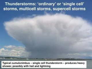
Thunderstorms: ‘ordinary’ or ‘single cell’ storms, multicell storms, supercell storms. Typical cumulonimbus – single cell thunderstorm – produces heavy shower, possibly with hail and lightning. Reading. Ahrens, Chapter 14: Thunderstorms and Tornadoes

Thunderstorms: ‘ordinary’ or ‘single cell’ storms, multicell storms, supercell storms
E N D
Presentation Transcript
Thunderstorms: ‘ordinary’ or ‘single cell’ storms, multicell storms, supercell storms Typical cumulonimbus – single cell thunderstorm – produces heavy shower, possibly with hail and lightning
Reading • Ahrens, Chapter 14: Thunderstorms and Tornadoes • This lecture + next (Lightning, tornadoes) will cover the topic.
What meteorological conditions precede a thunderstorm? • A conditionally unstable atmosphere • Substantial boundary layer moisture • A trigger to release the instability • On a skew T-log p plot:CAPE:Convective Available Potential Energy= energy that can be released CIN:Convective INhibition:= energy barrier that has to be overcome
Td Higher dew-point T = more moisture Pushes to higher SALR curve, i.e. higher CAPE Real example tephigram – large amount of CAPE – thunderstorm v.likely CAPE is given by thearea between SALR and environmentallapse rate CAPE
An important forecaster tool for predicting thunderstorms: Maps of CAPE (contours) and vertical velocity (+) Fri Nov 7 12Z2008 http://expert.woeurope.eu/cape_frame.htm
‘Ordinary’ or ‘single cell’ thunderstorms • Relatively small • Isolated • Typically just produce a single heavy shower, then dissipate. • Very little vertical wind shear (come back to this later)
Cumulus Congestus (Cumulus with large vertical extent) Stage 1: ‘Cumulus’
Cumulus stage (continued) • Buoyant updraught • Vertical velocity increases with height, to ~10 ms-1 at top • Surrounding air mixed in (entrainment) • Inside cloud, raindrops and supercooled drops grow, releasing latent heat • At edges, drops evaporate into entrained air – moistens the surrounding air. • As the environment moistens, successive updraughts sustain clouds to higher and higher levels • No rainfall at this stage
Isolated cumulonimbus Stage 2: ‘Mature’
Mature stage (continued) • Top of cloud extends to near tropopause levels (>10 km), well above 100% freezing level • Growth of drops & ice continues until updraught can no longer support them – start to fall • Entrainment of surrounding drier air tends to evaporate drops, cooling air • Both these processes lead to development of a downdraught • Updraught+downdraught=‘cell’ – ‘single cell’ thunderstorm • Most intense stage – heavy rain, thunder, lightning • Anvil starts to form at top -40°C 10 km 5 km 0°C
Cumulonimbus dissipates, just leaving anvil – eventually leavingonly cirrus Stage 3: ‘Dissipating’
Downdraught grows until it cuts off flow of air to the updraught – the storm has its ‘fuel supply’ stopped Rainfall declines and the lower part of the cloud evaporates Rainfall stops; all that is left is the anvil All 3 stages pass in typically about 1 hour - a rapid, heavy shower Dissipating stage (continued)
Summary: ‘single cell’ storm Mature Dissipating Cumulus
Vertical wind shear • Why might this be important?
Downdraught Gust front Approaching mature stage Dissipating stage
Multi-cell thunderstorms • This type of thunderstorm is where once one cell subsides, another grows in its place, adjacent to the last cell • The downdraught causes a ‘gust front’ when it meets the surface. This may push up surrounding moist air and trigger a new cell to develop. • The presence of vertical wind shear can help thunderstorm development and persistence by separating the updraught from the downdraught
Vertical Wind Shear Shear ‘tilts’ the storm, helping it propagate, increases its lifetime and severity Promotes formation of new cells – i.e. a multicell storm
Relative to flow at mid-level Flow at mid-level Since mass cannotaccumulate, theremust also be verticalmotion (red arrows) Shear isequivalent torotation Shear and rotation
Updraught‘bends’ upwardsvorticity Horizontal shear combined withan updraught can lead to a stormacquiring vorticity about a verticalaxis Vorticityassociatedwithhorizontalshear
Supercell thunderstorms • Rotating updraught • Rotation causes the storm to be more robust – longer-lived, and therefore more dangerous • Forms an area of low pressure at centre of rotation, called a mesolow • Updraught centred on the low pressure • Circulation around the low is in cyclostrophic balance…