Weather Basics and Storm Avoidance in Advanced Navigation
460 likes | 492 Vues
Understand the basics of weather elements and the principles of storm avoidance in navigation. Learn about air masses, frontal zones, warm and cold fronts, and safe maneuvering techniques.

Weather Basics and Storm Avoidance in Advanced Navigation
E N D
Presentation Transcript
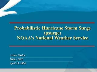
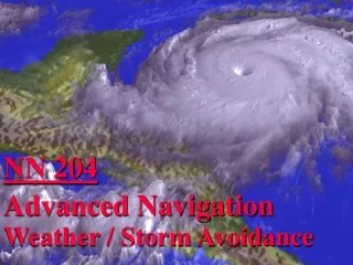
NN 204 Advanced Navigation Weather / Storm Avoidance
Objectives 1. Be able to describe the major differences between warm, cold, and occluded fronts. 2. Be able to briefly describe the different heavy weather terms. 3. Understand when a ship is required to submit weather synoptics and with what periodicity.
Objectives 4. Be able to list the basic information included in a hourly observation. 5. Be able to define the different weather services available to the ship’s nav team. 6. Be able to determine the most dangerous and least dangerous (navigable) semicircles associated with a tropical storm.
Objectives 7. Be able to draw the different safe maneuvering techniques in relation to a tropical storm.
Weather Basics • Weather is the state of the atmosphere as defined by various meteorological elements (pressure, temperature, precipitation, etc…) • Simply speaking, all weather can be traced to the effect of the sun on the earth. Changes in the weather are a result of the large scale horizontal movement of air (Air in motion is called Wind). • This movement of air is caused by differences in atmospheric pressure, temperature and the motion of the earth along it’s axis.
Weather Basics • The area of the earth around the equator is subject to the greatest heating, while the area around the poles is subject to the least amount of heating. • Hot air is less dense and rises, while cold air is more dense. Therefore, the region around the equator is a region of lower pressure. The Hot air rises, then circulates towards the poles as it cools. This simplified relationship is expressed in the next slide.
Rotation of the World 60 Deg 30 Deg Horse Latitudes High Pressure Doldrums Low Pressure 0 Deg High Pressure 30 Deg Horse Latitudes 60 Deg
Weather Basics • The movement of air caused by temperature changes is also altered by the rotation of the earth. This rotation exerts the Coriolis Force which diverts the air from a direct path from High to Low pressure. • These forces combined change through the seasons and steer all the weather systems along the surface of the earth.
Rotation of the World 60 Deg 30 Deg High Pressure Low Pressure 0 Deg High Pressure 30 Deg 60 Deg
Air Masses • - Differences in the surface of the earth (ocean, mountain, desert, etc..) cause the air over these regions to take their same characteristics with respect to their temperature, moisture, etc.. • The region of air that has these same characteristics is called an Air Mass. • As air masses move about the earth according to the general circulation described earlier, they collide. The area of separation between two differing air masses is called a Frontal Zone, or Front.
Fronts • Fronts tend to move in a wave like pattern in the direction of the general circulation. • A front where warm air along the leading edge is replacing colder air is called a Warm Front. • A Front where cold air along the leading edge is replacing warmer air is called a Cold Front.
Warm Fronts Active Warm Fronts are generally located in pressure troughs. Other identifiers: 1. Pressure - Pressure usually falls for an appreciable length of time before the front passes. 2. Wind - Wind, usually from the southeast in the northern hemisphere, increases as the front approaches.
Warm Fronts 3. Clouds - Nearly always well defined by stratified clouds, generally: cirrus, cirro- stratus, altostratus, nimbostratus, and stratus, with cirrus appearing as much as 1000 miles before the surface passage. 4. Precipitation - Extends about 300 miles in front of the surface front in the form of intermittent rain, snow, drizzle.
Warm Fronts 5. Temps & Dew Point - Temp change is gradual. Dew Point normally observed to rise as the front approaches, and to further increase as the frontal passage if the air in the warm sector is of maritime origin. 6. Visibility & Ceiling - Visibility & ceiling are normally good until the precipitation begins, then they decrease rapidly.
WARM FRONT STABLE CONDITIONS 30,000 CI Stable warm air CS 20,000 AS NS AS 10,000 ST SC FOG RAIN AND LOW NIMBUSTRATUS 200 100 0 100 200 300 400 500
CB 30,000 CI CS Unstable warm air 20,000 WARM FRONT UNSTABLE CONDITIONS AS NS AS 10,000 ST SHOWERS LIGTH RAIN AND SHOWERS 200 100 0 100 200 300 400 500 600
CB 30,000 CI CS Unstable warm air 20,000 WARM FRONT UNSTABLE CONDITIONS AS NS AS 10,000 ST SHOWERS LIGTH RAIN AND SHOWERS 200 100 0 100 200 300 400 500 600
Cold Fronts Cold Fronts are generally located in well-defined pressure troughs whenever there is a marked contrast between two air masses. Other identifiers: 1. Pressure - The pressure characteristic is usually indicated by steady or unsteady fall. 2. Wind - Usually from the south or southwest in the northern hemisphere, veering to parallel the front.
Cold Fronts 3. Clouds - Typical of warm air: towering cumulus, cumulonimbus, stratocumulus, and nimbostratus. 4. Precipitation - Showers and thunderstorms occur as the cold front passes.
Cold Fronts 5. Temps & Dew Point - Temp is relatively high before passage, dropping as the front passes. Dew Point is observed to drop, especially in mountainous regions. 6. Visibility & Ceiling - Visibility & ceiling decrease and remain low after the passage until well within the cold air.
CIRRUS CIRROSTRATUS POSIBLE CUMULONIMBUS 15,000 ALTOCUMULUS 10,000 0º NIMBOSTRATUS 5,000 CUMULUS STRATOS STRATOCUMULUS 200 MILES 0 100 100
CIRRUS FAST MOVING COLD FRONT CIRROSTRATUS 15,000 ALTOCUMULUS NIMBOSTRATUS 10,000 CUMULONIMBUS 0º 5,000 STRATOCUMULUS 200 MILES 0 100 100
CIRRUS FAST MOVING COLD FRONT CIRROSTRATUS 15,000 ALTOCUMULUS NIMBOSTRATUS 10,000 CUMULONIMBUS 0º 5,000 STRATOCUMULUS 200 MILES 0 100 100
Occluded Fronts 1. Cold Occlusion - Warm air is lifted, all clouds associated with a warm front are found producing typical prefrontal precipitation with cold front weather in the vicinity of the surface. 2. Warm Occlusion - similar weather to Cold Occluded with high level thunderstorms and a wider weather band.
WARM AIR WARM FRONT SURFACE COLDER AIR COLD AIR COLD TYPE OCCLUSION
WARM AIR WARM FRONT SURFACE COLD AIR COLDER AIR WARM TYPE OCCLUSION
Heavy Weather 1. Closed Cyclonic - Rotary circulation storms. 2. Noncyclonic - Storms produced by prevailing winds are identified by their accompanying winds - predictable.
Closed Cyclonic 1. Tornadoes - Violent, whirling storm of small diameter that travels across land. Appear as funnel shaped cloud, with a vortex that may or may not touch the earth. Winds blow spirally upwards from 150 - 300 mph. 2. Waterspouts - Similar to tornadoes, occuring over oceans or inland waters. Usually less destructive than tornadoes.
Closed Cyclonic 3. Squall - A wind of considerable intensity caused by atmospheric instability. Comes up & dies quickly, sometimes accompanied by thunder, lightning and precipitation. 4. Monsoons - Steady winds somewhat similar to trade winds. Can reach moderate gale proportions and are accompanied by heavy squalls and thunderstorms during the summer.
Closed Cyclonic 5. Hurricanes - Tropical storm with continuous winds greater than 75 mph (64 kts). 6. Tropical Storms - Categorized based on wind speed: - Tropical Depression: < 34 kts - Tropical Storm: 34 - 63 kts - Hurricane: > 63 kts
Noncyclonic ie: gale - with winds from 34 - 47 mph storm - with winds of 48 mph or greater.
Ship Observation & Reporting Weather Observations - Ships are required to take regular weather observations: - Observations taken hourly iaw NAVOCEANINST. - Ships in company, OTC may designate one ship to report observations - In port with no manned weather facility within 50NM
Ship Observation & Reporting Synoptic - Formatted weather message: - Every 6 hours PRIORITY if: surface wind speeds < 33 kts, seas < 12 feet. - Every 3 hours IMMEDIATE if: surface winds > 33 kts sustained, seas > 12 feet. - Via plain voice: first indications of a tropical cyclone, unusual or hazardous weather.
Ship Observation & Reporting Weather Observations - prepared by OOD: - Type of observation - Cloud Cover - Prevailing visibility - Weather & obstructions to visibility - Sea level pressure in millibars
Ship Observation & Reporting Weather Observations - prepared by OOD: (cont.) - Dry bulb temp in degrees fahrenheit - Dew point temp in degrees fahrenheit - True wind direction & speed - Altimeter setting (if aircraft embarked) - Remarks
Ship Observation & Reporting Weather Observations - prepared by OOD: (cont.) - Station pressure in inches of mercury - Sea water temp (at sea water injection) - Sea height, direction and period - Ice (if applicable) - Clouds by type, quantity, & height
Services Available 1. Tropical Cyclone Alert: GIF image 688x494 pixels 2. High Wind and Sea Warning: GIF image 595x601 pixels 3. Local Severe-Storm Warning 4. WEAX: FOXX 1 5. OTSR - Optimum Track Ships Routing
Storm Avoidance 1. Hurricane Season - June through November 2. Procedure - Safest with respect to tropical cyclones is avoidance. 3. Key Elements to Determine: - Position relative to storm center & axis - Path & velocity of storm’s travel
Storm Avoidance 4. Cyclonic Storms - Deflected by the corriolis effect travel in a clockwise direction (Northern Hemisphere). 5. Storm Division - Storm is divided into 2 parts: - Most Dangerous Semi-circle - side that is right of storm center and direction of path - LeastDangerous Semi-circle - side that is left of storm center and direction of path
Northern Hemisphere Most Dangerous Quadrant More Dangerous Semi-circle Least Dangerous Semi-circle
Direction of travel - Hurricane Bonnie
Storm Avoidance 6. Safe Passage - in the Northern Hemisphere - Avoid crossing the “T”:avoid passing in front of a storm going from Most to Least Dangerous semi-circle - Most Dangerous Semi-Circle:Bring the wind on STBD bow, hold course & make best speed.
Storm Avoidance 6. Safe Passage - in the Northern Hemisphere - Least Dangerous Semi-Circle:Bring the wind on STBD qtr, hold course & make best speed. - On Storm Track (ahead):Bring the wind to 160 deg R until a backing is noted in the wind (indicating you are in the Least Dangerous Semi-circle), then bring the wind on STBD quarter, hold course & make best speed.
Storm Avoidance 6. Safe Passage - in the Northern Hemisphere - On Storm Track (behind):Avoid the center by best practical course (southerly).