
5 Day Spring Break Trail
Hiking Resources in Dickinson College’s Own Backyard. 5 Day Spring Break Trail.

5 Day Spring Break Trail
E N D
Presentation Transcript
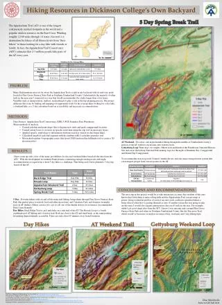
Hiking Resources in Dickinson College’s Own Backyard 5 Day Spring Break Trail The Appalachian Trail (AT) is one of the longest continuously marked footpaths in the world and a popular outdoor resource on the East Coast. Winding roughly 2,180 miles through 14 states, this trail is a destination for hikers of all fitness levels from “thru-hikers” to those looking for a day hike with friends or family. In fact, the Appalachian Trail Conservancy (ATC) estimates that 2-3 million people hike parts of the AT every year. Statistics for the Average Hiker PROBLEM Many Dickinsonians may not be aware the Appalachian Trail is right in our backyard with its mid-way point located at Pine Grove Furnace State Park in Southern Cumberland County. Unfortunately the majority of other trails in the areaaren’t connected in a way that would accommodate for a hikelonger than a few hours. Variables such as transportation, shelters, and parking lots play a role in the trip planning process. My project addresses this issue by finding and mapping out appropriate trails for the average hiker looking for a day hike, a weekend hike, or a 5 day adventure based on accessibility and necessary accommodations. METHODS • Data Sources: Appalachian Trail Conservancy, ESRI, USGS Seamless Data Warehouse • Major methods of analysis: • Created polyline and point shape files to digitize new trails and mark campground locations. • Created extent boxes to zoom in on specific trails then using the clip tool on necessary layers. • Appliedspecific symbology to differentiate between each day stretch for the longer hikes. • Calculated length of each trail segment with the attribute table’s calculate geometry tool. • Mosaicked together 4 topographic raster files from USGS and usedthe hillshade tool to create a 3D elevation effect. • AT Weekend : Two days, one night-Includes hiking through the middle of Cumberland County’s portion of the AT with two excursions onto forestry trails. • Gettysburg Loop Three days, two nights- Hikers start and finish at the Eisenhower National Historic Site and circle Gettysburg National Park making stops for the night at Drummer Boy Campground and Round Top Campground. • To accommodate non-loop trails I found 3 shuttle drivers and one major transportation system that can transport people from various points on the AT. RESULTS I have come up with a few of the many possibilities for day and weekend hikes based off the data from the ATC. With the development in southern Pennsylvania, connecting enough existing trails with night accommodations to equal even a short 5 day hike is a challenge. That being said, I have planned a 5 day trip based off the AT. CONCLUSIONS AND RECOMMENDATIONS The next step in this project would be to take terrain into account. Any resident of this area knows that Gettysburg is more rolling hills and the Appalachian Trail can get steep at points; doing evaluation profilesof each of my new trails could give potential hikers a better idea of what they’re getting themselves into. If another researcher was going to take on this topic I would also suggest getting more data on alltrails in the area. For example, while I got good shape files from the ATC, I know I was missing trails around Pine Grove Furnace State Park and others in Northern Cumberland County like the Tuscarora Trail which would’ve been nice to analyze in terms of day, weekend, and 5 day hiking trips. 5 Day : Provides hikers with on and off the main trail hiking, brings them through Pine Grove Furnace State Park (the perfect place to restock food and other necessities) and Caledonia Park, and features overnight stays in AT shelters. Hikers can use two cars or call one of the shuttle drivers for assistance (recommended: Don’s Auto Rentals) Day Hikes: Buck Ridge Trail is an 8 mile hike on a side trail of the AT. The Hosack Loop is a 6 mile combination of AT hiking and a forestry trail. Both are close to the AT and start/finish at the same parking lot making them extremely accessible. These are only about 45 minutes away from Dickinson. Gettysburg Weekend Loop AT Weekend Trail Day Hikes Trail Trove Hiking and Backpacking Trails available at: http://trailtrove.com/hiking-speed Pennsylvania Campgrounds available at: http://www.hikercentral.com/campgroundstates/pa.html A.T. Shuttles and Public Transportation. Appalachian Trail Conservancy available at: http://www.appalachiantrail.org/docs/default-document-library/AT%20Shuttle%20List%20WEB%206-7-11.pdf USGS Seamless Data Warehouse available at: http://seamless.usgs.gov/ Pennsylvania Visitors Network available at: http://www.pavisnet.com/cgi-bin/page3.cgi?dir=adams&what=stay&category=camp Mapping GIS Data. Appalachian Trail Conservancy available at: http://www.appalachiantrail.org/about-the-trail/mapping-gis-data Elise Minichiello Intro to GIS Fall 2011