Remote Sensing Image Acquisition
Remote Sensing Image Acquisition. Supplement to Lecture 1 material prepared by R. Lathrop 9/99 updated 8/03 includes slides previously prepared by S. Madry and C. Colvard Readings: ERDAS Field Guide 5th Ed. Ch 1, 3:56-82. Digital Image Acquisition.


Remote Sensing Image Acquisition
E N D
Presentation Transcript
Remote Sensing Image Acquisition Supplement to Lecture 1 material prepared by R. Lathrop 9/99 updated 8/03 includes slides previously prepared by S. Madry and C. Colvard Readings: ERDAS Field Guide 5th Ed. Ch 1, 3:56-82
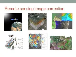
Digital Image Acquisition • Digitization of analog aerial photography, can be very useful for historical studies and/or for high spatial resolution needs • Direct acquisition using some form of digital imaging sensor
Early attempts • Kite system acquired aerial photos of the great San Francisco earthquake and fire • Pigeon cameras • The development of aircraft • World Wars I and II
Aerial Cameras Keystone’s Wild RC-10 mapping camera A large format oblique camera
Aerial photos • Black & White - single panchromatic layer • Color: 3 layers B-G-R • Color IR: 3 layers G-R-NIR
USGS Aerial Photo Products Aerial Products Description National Aerial Photography Program (NAPP) Recent,high-quality aerial photos covering the conterminous U.S. on five- to seven-year cycles (1987 - present). National High Altitude Photography (NHAP) High-altitude aerial photos for the conterminous U.S. (1980 - 1989). Digital Orthophoto Quadrangles (DOQs) Digital images of aerial photos which combine the image characteristics of the photo with the georeferenced qualities of a map (1987 - present). Space Acquired Photography Photos taken from the International Space Station (ISS), Shuttle, Skylab, Gemini, and Apollo missions (1965 - present). For more info: http://edc.usgs.gov/products/aerial.html
Aerial Photographic Sources • USDA: (since 1955): mainly PAN of 1:20,000-1:40,000. These photos are archived by the Aerial Photography Field Office http://www.fsa.usda.gov/dam/APFO/airfto.htm • National Archives and Records Administration archives older (pre- 1950’s) aerial photography http://www.nara.gov/research/ordering/mapordr.html
Aerial Photographic Sources • National Ocean Survey (NOS) coastal photography: (since 1945), color, scales of 1;10,000 - 1:50,000 • The photos are used for a variety of geo-positioning applications, which include delineating the shoreline for Nautical Chart creation, measuring water depths, mapping seabed characteristics, and locating obstructions to marine and air navigation. • http://mapfinder.nos.noaa.gov
Analog Image Digitization • Can take analog photography and turn into digital images • Scanning micro-densitometer • Linear array charge-coupled device e.g., flat-bed scanners • Area array charge-coupled device e.g., digital camera
Airborne Digital Imaging Systems Aircraft ScannersDigital imagery acquired from several multispectral scanners on board NASA ER-2, NASA C-130B, and NASA Learjet aircrafts (1982 - 1995). For more info: http://edcdaac.usgs.gov/airborne/air_scan.html Digital Cameras increasingly aerial imagery is being acquired through digital camera framing systems that can collect multispectral (VIS-NIR) imagery and be quickly corrected through GPS-based navigational systems to produce digital orthophotographic imagery in near-real time
Space-borne Remote Sensing • Still Emerging Technology • Pro: • GIS ready • fast turn around • acquisition time of 5 minutes gives equal solar illumination, shadows • long term archive of repeat imagery for change detection • Con: • Significant investment in infrastructure • Less flexibility in acquisition
Remote Sensing Satellites in Space: How do they get there? http://visibleearth.nasa.gov/cgi-bin/viewrecord?492
MODIS Terra Launches http://visibleearth.nasa.gov/cgi-bin/viewrecord?135
Types of satellite orbits • Geostationary Polar 700-900 km 35,800 km
Polar Orbitting Satellite http://visibleearth.nasa.gov/cgi-bin/viewrecord?134
Geostationary vs. polar orbiting sensors Geostationary sensors orbit with the earth continually viewing the same hemispheric area Polar orbiters, continually view new areas of the earth as the planet rotates underneath the sensor. Keeps the same general solar time as it cross the equator on each orbit - called sun synchronous Polar orbit
AVHRR-Advanced Very High Resolution Radiometer • Polar orbit, coarse spatial resolution: 1 and 4 km cells, broad 2400 km ground swath width • 2 operational now-1 day and 1 night pass for each
AVHRR • Thermal AVHRR provides water temperature data • 3 bands in TIR Gulf Stream
Remote Sensing of the Earth: Clues to a Living Planet • Scientists at the NASA Goddard Space Flight Center have used the AVHRR to create maps of vegetation greenness for the entire globe • The NASA scientists have combined numbers of satellite images to create a composite picture of the earth at approximately biweekly intervals over a number of years For more info and images, go to: http://daac.gsfc.nasa.gov/CAMPAIGN_DOCS/BRS_SRVR/avhrrbrs_main.html
Global AVHRR composite • 1 band in the Red: .58-.6 um • 1 band in the NIR: .72-1.1 um • Vegetation Index to map vegetation amount and productivity
Remote Sensing of the Earth: Clues to a Living Planet • You can access these images over the INTERNET • http://daac.gsfc.nasa.gov/CAMPAIGN_DOCS/LAND_BIO/GLBDST_Images.html • You can either browse through individual images or watch an animation • First, click on the Global 1 degree 1986 NDVI (Climate Data Set) (1.5 MB Quicktime) animation. Open it, and click on the > button. You can go more slowly by clicking on the |> button.
Remote Sensing of the Earth: Clues to a Living Planet • First, click on the Global 1 degree 1986 NDVI (Climate Data Set) (1.5 MB Quicktime) animation. Open it, and click on the > button. • Watch closely, can you observe the Green Wave in the northern hemisphere? • What about the Brown Wave? • Now look at the southern hemisphere. What do you observe?
Can you see the Green Wave? http://daac.gsfc.nasa.gov/CAMPAIGN_DOCS/LAND_BIO/GLBDST_Images.html
Remote Sensing of the Earth: Clues to a Living Planet • Now take a look at the Northern hemisphere in greater detail. • Click on the North America 1986 NDVI (750K quicktime) Animation. • Can you find where you live? How long does it stay green? • Compare Florida with Maine or Minnesota.
North America: Close-up http://daac.gsfc.nasa.gov/CAMPAIGN_DOCS/LAND_BIO/GLBDST_Images.html
Remote Sensing of the Earth: Clues to a Living Planet • To access more recently acquired AVHRR imagery go to the National Oceanographic & Atmospheric Administration (NOAA) Satellite Active Archive http://www.saa.noaa.gov/
After a picture-perfect launch into space December 1999, Terra Began releasing images April 2000. Terra includes MODIS, a 2nd generation “AVHRR-like” instrument, with a number of potential applications in regional to global scale environmental monitoring of the land, ocean and atmosphere. Also includes ASTER, CERES, MISR and MOPITT. For more info go to: http://terra.nasa.gov/
MODIS TERRA in Orbit http://visibleearth.nasa.gov/cgi-bin/viewrecord?133
36 discrete bands between 0.4 and 14.5 µm • spatial resolutions of 250, 500, or 1,000 m at nadir. • Signal-to-noise ratios are greater than 500 at 1-km resolution (at a solar zenith angle of 70°), and absolute irradiance accuracies are < ±5% from 0.4 to 3 µm (2% relative to the sun) and 1 percent or better in the thermal infrared (3.7 to 14.5 µm). • MODIS instruments will provide daylight reflection and day/night emission spectral imaging of any point on the Earth at least every 2 days, operating continuously. • For more info: http://eospso.gsfc.nasa.gov/eos_homepage/mission_profiles/instruments/MODIS.php
3 visible/NIR(VNIR: 0.5 and 0.9 µm) with 15-m resolution • 3 mid IR (SWIR: 1.6 and 2.43 µm) with 30-m res. • 5 TIR (8 and 12 µm) with 90-m resolution • 60- km swath whose center is pointable cross-track ±8.55° in the SWIR and TIR, with the VNIR pointable out to ±24°. An additional VNIR telescope (aft pointing) covers the wavelength range of Channel 3. By combining these data with those for Channel 3, stereo views can be created, with a base-to-height ratio of 0.6. • Overpass every 16 days in all 14 bands and once every 5 days in the three VNIR channels. For more info: http://eospso.gsfc.nasa.gov/eos_homepage/mission_profiles/instruments/ASTER.php
“Aqua,” Latin for “water,” is a NASA Earth Science satellite mission named for the large amount of information that the mission will be collecting about the Earth’s water cycle, including evaporation from the oceans, water vapor in the atmosphere, clouds, precipitation, soil moisture, sea ice, land ice, and snow cover on the land and ice. Additional variables also being measured by Aqua include radiative energy fluxes, aerosols, vegetation cover on the land, phytoplankton and dissolved organic matter in the oceans, and air, land, and water temperatures.The AQUA Platform includes the MODIS, CERES and AMSR_E instruments. Aqua was formerly named EOS PM, signifying its afternoon equatorial crossing time.AQUA was launched May 2002.For more info: http://aqua.nasa.gov/
ENVISAT • In March 2002, the European Space Agency launched Envisat, an advanced polar-orbiting Earth observation satellite which provides measurements of the atmosphere, ocean, land, and ice. • http://envisat.esa.int/
ENVISAT: primary instruments for land/sea surface remote sensing • ASAR - Advanced Synthetic Aperture Radar, operating at C-band, • MERIS - is a 68.5 o field-of-view pushbroom imaging spectrometer that measures the solar radiation reflected by the Earth, at a ground spatial resolution of 300m, in 15 spectral bands, programmable in width and position, in the visible and near infra-red. MERIS allows global coverage of the Earth in 3 days. http://envisat.esa.int/
SPOT Vegetation • Earth observation sensor on board of the SPOT satellite in blue, red, NIR & SWIR • Daily coverage of the entire earth at a spatial resolution of 1 km • The first VEGETATION instrument is part of the SPOT 4 satellite and a second payload, VEGETATION 2, is now operationally operated onboard SPOT 5. • http://www.spot-vegetation.com/
SPOT Vegetation • Free products are : • extracts from ten day global syntheses. • available 3 months after insertion in the VEGETATION archive. • in full resolution (1km). • in plate carrée projection. • available on 10 predefined regions of interest. • in the standard VEGETATION product format. • http://free.vgt.vito.be/
ERTS-1 • Earth Resources Technology Satellite-1 • Renamed Landsat Multispectral scanner (MSS) • First images in late 1972 • Was the first civil remote sensing satellite
Landsat MSS bands 4 and 5 GREEN RED
Landsat MSS bands 6 and 7 Note: water absorbs IR energy-no return=black INFRARED 1 INFRARED 2
MSS color composite Manhattan Rutgers • combining bands creates a false color composite • red=vegetation • light blue=urban • black=water • pink=agriculture Philadelphia Pine barrens Chesapeake Bay Delaware River
Landsat TM-7 bands-8 bit data Spectral (where we look) Radiometric (how finely can we measure the return) 0-63, 0-255, 0-1023 Landsat TM BAND 1 2 3 4 5 7 6
Landsat TM: each waveband provides different information about earth surface features
Thermal imagery-temperature Water analysis-nuclear power cooling ponds)
Blew up at launch http://www.earth.nasa.gov/history/landsat/landsat.html
Commercialization of Landsat • Landsat was commercialized by Pres. Reagan • EOSAT formed • sales dropped
Landsat 7 • 15 m ETM+ (enhanced TM) sensor • April 1999 launch • Oct.’92 Land remote sensing policy act • a panchromatic band with 15m spatial resolution-fully coregistered w/30m • on-board, full aperture, 5% absolute radiometric calibration • a thermal IR channel with 60m spatial resolution • for more info go to: http://landsat.gsfc.nasa.gov/