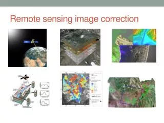
Remote Sensing Image Rectification and Restoration
Remote Sensing Image Rectification and Restoration. Image Rectification and Restoration. Geometric correction Radiometric correction Geometric restoration. 1. Geometric Correction. For raw image rectification For multi-date images registration


Remote Sensing Image Rectification and Restoration
E N D
Presentation Transcript
Image Rectification and Restoration • Geometric correction • Radiometric correction • Geometric restoration
1. Geometric Correction • For raw image rectification • For multi-date images registration • For multi-resolution images or data layers registration • Systematic distortion vs. random distortion
Skew Correction Coordinate transfer Pixel value resampling http://rst.gsfc.nasa.gov/Intro/Part2_15.html
Ground Control Points (GCP) • Features with known locations on a map (X,Y coordinates). These are the “ground control points” • The same features can be accurately located on the images as well (column, row numbers) • The features must be well distributed on the map and the image • Highway intersections are commonly used ground control points
Coordinate Transform • Coordinate transform equations relate geometrically correct map coordinates to the distorted image coordinates x = a0 + a1X + a2Y y = b0 + b1X + b2Y x,y: column, row number X,Y: coordinates • Root Mean Square Error (RMSE) = √(dx)2 + (dy)2 Calculate RMSE for all control points
Resampling • The purpose is to assign pixel values to the empty pixels in the rectified matrix output • Superimpose the rectified output matrix to the distorted image • The digital number (DN) of a pixel in the output matrix is assigned based on the DN of its surrounding pixels in the distorted image
Re-sampling Methods • Nearest neighbor resampling • Bilinear interpolation • Cubic convolution resampling
Nearest Neighbor Resampling • The DN of a pixel in the output matrix is assigned as the DN of the closest pixel in the distorted image • Advantages simple computation maintain the original values • Disadvantage spatial offset up to 1/2 pixel
Bi-linear Interpolation • Distance-weighted average of DN values of the closest 4 pixels • Advantage output image is smoother than the nearest neighbor method • Disadvantage alters the original DN values
Cubic Convolution Resampling • Uses DN values of the closest 16 pixels, adjusted by distance • Advantage smooth output image • Disadvantage alters the original DN values
When to Rectify • Rectify before image classification • Rectify after image classification
2. Radiometric Corrections Radiometric responses differ by • dates • sensor types • images • Causes: - Illumination - Atmospheric conditions - View angle or geometry - Instrument response
Radiometric Corrections • Sun elevation correction • Atmospheric correction • Conversion to absolute radiance
Sun Elevation Correction DN • -------------------------------- Sin (Sun elevation angle) • Assuming the terrain is flat
Satellite Summer Zenith Spring / Fall Solar Elevation Angles Winter Tangent plane Equator
Atmospheric Correction • Haze compensation The DN value of an object (e.g., a deep clear water body) with 0 reflectance = Lp • Subtract the DN from the entire band
Absolute Irradiance • Conversion of DN values to absolute radiance values • It is necessary when compare different sensors, or relate ground measurements to image data • L = (Lmax- Lmin)/255 * DN + Lmin
3. Geometric Restoration • Stripping • Line-drop • Bit errors
Striping • Malfunction of a detector • Use gray scale adjustment to correct the strips
Line Drop • using average of the above and below lines to fill the dropped line
Bit Error • Salt and pepper effect due to random error • Use 3x3 or 5x5 moving window average to remove the noise
Readings • Chapter 7
Earth-Sun Distance Correction E0 Cosq0 • E = ------------ d2 • Irradiance is inversely related to the square of the earth-sun distance • E - normalized solar irradiance • E0 - solar irradiance at the mean Earth-sun distance • q0 - sun angle from the zenith • d - Earth-sun distance
Atmospheric Correction rET • Ltot = --------- + Lp p r - reflection of target E - irradiance on the target T - transmission of atmosphere Lp - scattered path radiation