Enhancing Aviation Navigation: Overview of CAAC's Efforts in Efficient Air Traffic Management
160 likes | 292 Vues
This briefing presents an overview of advancements in navigation services for aviation, focusing on the initiatives by the Civil Aviation Administration of China (CAAC) at Stanford University. Key areas include efficient routing, streamlined arrivals, and comprehensive navigation systems like WAAS and GBAS, which provide precise position, navigation, and timing services. These innovations enhance aviation safety, reduce operational costs, and meet the growing demands of air traffic, all while addressing the challenges posed by aging navigation infrastructure.

Enhancing Aviation Navigation: Overview of CAAC's Efforts in Efficient Air Traffic Management
E N D
Presentation Transcript
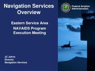
Navigation Services Overview Briefing to Air Traffic Management Bureau of the Civil Aviation Administration of China (CAAC) at Stanford University JC Johns Director Navigation Services
Efficient, Flexible Routing Vector Free - Streamlined Arrivals - Departures All Weather Approaches Navigation Services Vision • Provide safeandcost effective position, navigation, and timing services (PNT) to meet the operational needs of aviation customers.
Ground-Based Navigation Aides • Only a handful of ILS are being added (congressional) • Sustainment effort is minimal and focused on MK-1D and MK-1E systems • Long Term sustainment effort will be focused on Cat II/III runways • DME service continues well into the future • Sustainment effort robust, replacing obsolete systems • Establishing efforts ongoing in support of CFIT(CAST) • NextGen initiative to support enroute and terminal solutions Distance Measuring Equipment (Slant Range - UHF) Glideslope (Vertical Guidance - UHF Frequencies) • VOR drawdown has begun • Each legacy VOR that is eliminated reduces overall cost to FAA • Critical VORs will be maintained at certain waypoints and facilities for the foreseeable future Localizer (Lateral Guidance - VHF Frequencies) VHF Omnidirectional Range
Lighting Systems • Maintaining Safety Standards and Requirements • To help enable instrument approaches at airports • Types of Airport lighting currently being addressed • PAPI, VASI, MALSR, ALSF, REIL, Taxiway Indicators • New Initiative • Reducing Life-Cycle Cost of Lighting Systems: • Maintenance costs • Energy consumption reduction • LEDs
Wide Area Augmentation System (WAAS) Architecture 38 Reference Stations 3 Master Stations 4 Ground Earth Stations 2 Geostationary Satellite Links 2 Operational Control Centers
WAAS GEOs PanAmSat 133°W Telesat 107°W
WAAS Benefits • Serves all classes of aircraft during flight operations in all weather conditions at all locations throughout the National Airspace System (NAS) • Provides precise navigation and landing guidance to pilots at all airports, including thousands that have no ground-based navigation aids • Overcomes obstacles to ground-based systems, such as mountainous terrain • Reduces operating and maintenance costs associated with ground-based navigation aids • Makes more airspace usable to pilots, provides more direct en route paths, and provides new precision approach services to runway ends • Through international cooperation provides a global navigation system for all users • WAAS addresses the following performance gaps: • Lack of precise navigation capabilities that can handle the continuing growth in air traffic • Lack of stable vertical guidance in all weather conditions • Inconsistencies in global use of GPS and its augmentations • Aging of navigation systems that are expensive to maintain
Ground Based Augmentation System (GBAS)Capabilities • Represented in the US by Local Area Augmentation System (LAAS) • One LAAS covers multiple runway ends • LAAS eliminates ILS critical areas • Supports offset landing thresholds and flexible glide-path to mitigate wake turbulence • Contributing technology for high precision terminal area navigation services • Closely Spaced Parallel Approach • Simultaneous Independent Approach • Precise positioning for terminal area navigation RNAV and RNP • Benefits: • Replaces aging navigation systems that are expensive to maintain • Increases efficiency of arrival and departure operations and improves usage of runway capacity • Supports fuel efficiency and noise abatement initiatives • Improves access to airports during extremely low visibility operations
GBAS, GBAS Prototypes, and SCAT-1 Installations Installed • Multiple companies researching/developing versions of GBAS • USA – Honeywell / Raytheon (JPALS) - France - Thales • Russia - NPPF Spectr - Denmark – GM Merc/Lens, • Japan – JCAB/ENRI - Korea - KARA, Planned S-CAT I
Airline Commitments • Aircraft with GBAS capability today: 53(Continental, Qantas, Air Berlin, TuiFly, Sonair, Air Vanatu, FedEx) • 60+ Airlines have ordered GBAS capable Boeing/Airbus aircraft • Boeing orders estimated at 1000+ airplanes (B787, B747-8, B737NG) • GBAS standard on B787 and B 747-8 B 787 orders A 380 orders with GBAS option 895 orders by 57 customers