Download

1 / 8
80 likes | 91 Vues
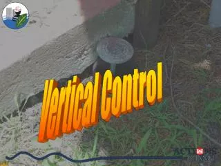
The project aims to establish vertical monuments facilitating precise property line placement at Lake Malone, Kentucky. Using common vertical data to enhance survey consistency and reduce survey costs for landowners.

E N D
Lake Malone Vertical Control Monument Project Commonwealth of Kentucky Tourism, Arts and Heritage Cabinet Department of Fish and Wildlife Resources Engineering Division Survey Branch Kelly Carr, PLS
Project Purpose • To establish vertical monuments that will aid in the accurate placement of property lines adjacent to Lake Malone.
Present Situation Existing surveys have used varied methods to establish property lines around the lake. • spillway elevation • water level on a given day • low water • high water Original deed descriptions can be misunderstood when basic principles of surveying are not applied. Adjoining owners may believe property rights extend to the water when in fact the rights that exists are for public use. Deed distances are measured horizontal. • Every survey shall be made by horizontal measurement. -Kentucky Revised Statute 73.070(1) • In plane surveying the reference base for field work and computations is assumed to be a flat horizontal surface. -Wolf & Brinker, Elementary Surveying, Ninth Edition. New York: HarperCollins 1994
Mission To provide the necessary vertical tie to the spillway elevation to locate property lines adjacent to Lake Malone. • Owners will need to retain the services of a local surveyor to utilize this information to locate property lines. • Availability of data may result in more economical survey costs for local owners. • Use of a common vertical datum will facilitate consistency between new surveys. • 15 Monuments were placed for ease of use. • High visibility markers are placed at monuments to aid in recovery. • Any point on the Lake is less than 1 mile from a monument. • Monument data sheets are available to local Land Surveyors. • Monument data sheets are published on website for public use. http://fw.ky.gov/