Download

1 / 44
440 likes | 466 Vues
This paper explores the use of an expert system, SIGGI-AACS, to automate the classification and analysis of distinctive projectile point types in the Northern Intermountain West. SIGGI learns to think like an archaeologist, utilizing established classification systems and statistical methods to make objective assessments and comparisons. The results show the effectiveness of SIGGI in identifying and classifying projectile point types.

E N D
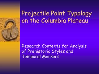
Detailed Automated Comparisons of Distinctive Projectile Point Type Sequences in the Northern Intermountain West by E.S. Lohse, Corey Schou, R. Schlader and D. Sammons; Informatics Research Institute, Idaho State University Paper presented at 63rd Annual Plains Conference Edmonton, Alberta, Canada Oct 19-23, 2005.
Expert System: SIGGI-AACS SIGGI is • a Neural Agent • who Learns Rules • and Thinks Creatively
SIGGI’s Thoughts • To train a neural agent in an AI system we must make implicit referential systems explicit • We extract expert knowledge and create hierarchical structures or decision trees • Siggi learns to “think” like an archaeologist • But Siggi has reference to much more authenticated data
Domain Expert: Lohse (1985), Columbia Plateau cultural area Rufus Wood Lake projectile point chronology used. Large collection with established provenience and radiocarbon dates. Lohse classification chosen because it was explicitly based on established types, had clean provenience information, a suite of radiocarbon dates, a clear analytical framework, and was statistically driven. SIGGI Prototype
Expert Training: Lohse 1985 • SIGGI has currently been trained to employ the classification system developed by Lohse (1985) for the Columbia Plateau • Explicit • Statistically based • Authenticated data • Community acceptance
1st Order Rules: Lanceolates • Variable forms are reduced to abstract geometric ideals • SIGGI is taught that this is important and that this leads to further distinctions
Classifying Points in Multidimensional Space • Handles real-world variability • Creates measurable relationships • Defines polythetic sets that offer discrimination between “types” • Constructs discriminant functions that distinguish between sets and individual specimens • Allows continued classification and objective assessments of class relations as the dataset expands
Series centroid plots • 6 morphological type series • Clear statistical separation • Simple lanceolate and side-notched series show greatest separation
Discriminant functions • A mathematical function is a Cartesian product of a set by itself where each pair of the product is assigned a real number • Relations are sets of ordered pairs where functions are sets of ordered triples • Measured points can be placed in matrices and distances plotted (correlation matrices)
Rotated standardized discriminant function coefficients, lanceolate run (Lohse 1985) • F1: haft length • F2: neck width, blade width, shoulder angle, shoulder length • F1 and F2 adequately explain 91% of the variation in lanceolate types Table 11-6, Lohse 1985 Conclusion: for lanceolates, haft length and development of well defined shoulders, coupled with blade width and neck width are the major variables used to distinguish recognized lanceolate from shouldered lanceolate types.
Rotated standardized discriminant function coefficients, triangular run (Lohse 1985) Table 11-7, Lohse 1985 Conclusion: for triangular points, variance in form is more subtle than in Lanceolate types, and the primary discriminating variables are shoulder Angle, basal margin angle and stem size or overall proportion, reflected in Basal width and the ratio between neck and basal width.
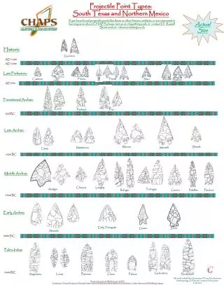
Rufus Wood Lake Projectile Point Chronology Modal types - descriptive - historical
Measurement Grids Triangular Forms Lanceolate Forms
SIGGI doesn’t use discriminant analysis … • SIGGI is short for use of “sigmoid functions” as part of curve fitting related to form recognition • Sigmoid functions are often used in neural networks to introduce nonlinearity in the model and to make sure that certain signals remain within a specified range. • A popular neural net element computes a linear combination of its input signals, and applies a bounded sigmoid function to the result; this model can be seen as a "smoothed" variant of the classical threshold neuron. http://www.answers.com/topic/sigmoid-function
Curve fitting … sigmoid functions http://mathworld.wolfram.com/SigmoidFunction.html
Actual outlines are reduced to geometric forms • Objects defined in a descriptive system can be conceived as points in space, whose dimensions are descriptors of the objects - 2D space (2 measured axes; elements in the vectors): distributions are regular, linear, clustered or random - 3D space (Euclidean 3D space; 5D; etc.; coordinates constitute vectors): clusters now occur in multiple dimensions • N=2 clusters in the 5 empirical dimensions constitute 2 new abstract dimensions composed of multiple descriptors
Importance of Latent Dimensions • Data elements are transformed into latent dimensions in order to manipulate solutions at the abstract or symbolic level • Latent dimensions can be found easily on the computer • The latent dimensions are archaeological structures (= polythetic sets) • Identification of latent dimensions allows removal of unnecessary information using Bayesian inference models http://reach.ucf.edu/~aln/pyle/theory.html
TYPES RULES FOR INCLUSION OF DATA: 1- A defined type must have a clearly proscribed range of variation defined quantitatively or qualitatively 2- The named type must have been recovered in definable archaeological contexts, and is isolatable in specific stratigraphic sequences
SITES RULES FOR INCLUSION OF DATA: 1- Sites must have been excavated in cultural stratigraphic levels and not in natural or arbitrary levels. 2- Provenience information must be available for all recovered artifacts that specifies cultural units as to stratum, feature and association. 3- A detailed descriptive report covering excavation methodology and analysis must be published for the site or be in the process of publication, and excavation notes and photographs must be on file at a recognizedrepository.
ASSEMBLAGES RULES FOR INCLUSION OF DATA: 1- An artifact distribution to qualify as a site activity assemblage must be defined in a discrete vertical and horizontal distribution associated with a recognizable cultural feature. 2- The cultural and natural stratigraphy must indicate that the assemblage represents a discrete prehistoric activity. The assemblage is not an analytical construct but a found context. 3- The assemblage indicates a discrete series of tasks or task-related activities. The assemblage is not an amalgam of activities over an extended period of time reflecting different seasons of site use nor different uses in different years.
TYPES AND ASSEMBLAGES Assemblage: Windust; a composite Types: Windust, Cascade and Cold Springs S-n • Windust and Cascade are distinctive to region (=“cultures”) • Large Side-n non- distinctive as regional indicator (= associated temporal marker) Ames et al. 1998; reproduced from Leonhardy and Rice 1970
Plateau Arche-Types Rabbit Island Cascade Windust Lind Coulee
Middle Archaic C-n Forms How to identify common and unique types? Columbia Plateau: these are Columbia C-n, large and small Plains: these are Pelican Lake specimens Basin: these are Elko C-n specimens http://www.abheritage.ca/alberta/archaeology/i_pelican.html
Late Archaic S-n Forms How to identify common and unique types? Columbia Plateau: these are Plateau S-n Plains: these are Avonlea specimens Basin: these are Desert S-n specimens http://lithiccastinglab.com/gallery-pages/avonleagrouplarge.htm
To Do … • Obtain information from domain experts • Columbia Plateau • Northwestern Plains • Great Basin • Classify methods by interactions with domain experts • Classify by types of information elicited from domain experts
Expert Interactions 1 • Interviews (concept mapping, cognitive structure analysis, data flow models, task action mapping) • Case Studies (context-driven) • Protocols (actions and mental processes) • Critiquing
Expert Interactions 2 • Role Playing • Simulations • Prototyping (expert evals, iterative system evals, rapid prototyping, storyboarding) • Teach-back • Basic observation
Need for authenticity • Only data that can be verified will be entered into the database • used to train SIGGI • used to test SIGGI • Explicit rules for inclusion can be constructed • sites to include • assemblages to include
Conclusions • SIGGI was developed as • an explicit classification system based on accepted typologies • a smart user interface to • manipulate large relational databases • explore the nature of archaeological classification • SIGGI as a prototype is smart enough to • classify specimens into general accepted types • begin explicit comparisons between cultural areas • begin knowledge elicitation experiments with archaeological experts
Suggested References • Lohse, E.S., D. Sammons, C. Schou, A. Strickland, and R. Schlader, 2005, Developing Archaeological Informatics: A Proposed Agenda for the Next FiveYears. Paper to be published in Proceedings of the 2004 Computer Applications in Archaeology Conference, BAR International Series, N. Niccolucci (ed.). • Lohse, E.S., C. Schou, A. Strickland, D. Sammons and R. Schlader, 2004, Automated Classification of Stone Projectile Points in a Neural Network, in Magistrat der Stadt Wien – Referat Ulturelles Erbe – Stadarchaeologie Wien (eds.), Enter the Past: The E-Way into the four Dimensions of Cultural Heritage, BAR International Series 1227, pp. 431-433. Oxford. • Lohse, E.S., 1995, Northern Intermountain West Projectile Point Chronology. Tebiwa 25(1): 3-51. • Lohse, E.S., 1985, Rufus Woods Lake Projectile Point Chronology, in S.K. Campbell (ed.), Summary of Results, Chief Joseph Dam Cultural Resources Project, Washington, pp. 317-364. Final Report to the U.S. Army Corps of Engineers, Seattle District. Office of Public Archaeology, University of Washington, Seattle.
Informatics Research Institute • Center for Innovative Technology In Archeological Informatics CITI-AI http://iri.isu.edu/AIRC.htm